Orontes River
The Orontes (/ɔːˈrɒntiːz/; from Ancient Greek Ὀρόντης, Oróntēs) or Asi (Arabic: العاصي, al-‘Āṣī, IPA: [alʕaːsˤiː]; Turkish: Asi) is a 571-kilometer-long (355 mi) river in Western Asia that begins in Lebanon, flowing northwards through Syria before entering the Mediterranean Sea near Samandağ in Turkey.[1]
| Orontes Asi | |
|---|---|
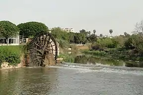 The Norias of Hama along the Orontes in Syria | |
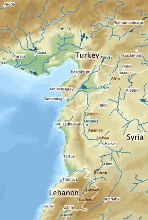 Map of the Orontes. White lines are country borders, river names are italic on a blue background, current cities or major towns on white backgrounds, other places of significance on orange backgrounds. | |
| Native name | Arabic: العاصي; Turkish: Asi |
| Location | |
| Country | Lebanon, Syria, Turkey |
| Cities | Homs, Hama, Jisr al-Shughur, Antakya |
| Physical characteristics | |
| Source | Labweh |
| • location | Beqaa Valley, Lebanon |
| • coordinates | 34°11′49″N 36°21′9″E |
| • elevation | 910 m (2,990 ft) |
| Mouth | Samandağ |
• location | Hatay Province, Turkey |
• coordinates | 36°2′43″N 35°57′49″E |
| Length | 571 km (355 mi) |
| Basin size | 24,660[1] km2 (9,520 sq mi) |
| Discharge | |
| • average | 11 m3/s (390 cu ft/s) |
As the chief river of the ancient Levant region, the Orontes was the site of several major battles. Among the most important cities on the river are Homs, Hama, Jisr al-Shughur, and Antakya (the ancient Antioch, which was also known as "Antioch on the Orontes").
Names
In the 9th century BCE, the ancient Assyrians referred to the river as Arantu, and the nearby Egyptians called it Araunti.[2] The etymology of the name is unknown,[2] yet some sources indicate that it might be derived from Arnt which means "lioness" in Syriac languages;[lower-alpha 1] others called it Alimas, a "water goddess" in Aramaic.[3] However, Arantu gradually became "Orontes" in Greek.
In the Greek epic poem Dionysiaca (circa 400 CE), the river is said to have been named after Orontes, an Indian military leader who killed himself and fell into the river after losing to Dionysus in single combat.[4] According to the Greek geographer Strabo (in Geographica, circa 20 CE), the river was originally named Typhon, because it was said that Zeus had struck the dragon Typhon down from the sky with thunder, and the river had formed where Typhon's body had fallen;[5] however, the river was later renamed Orontes when a man named Orontes built a bridge on it.[5][lower-alpha 2]
In contrast, Macedonian settlers in Apamea named it the Axius, after a Macedonian river god. The Arabic name العاصي (al-‘Āṣī) is derived from the ancient Axius. The word coincidentally means "insubordinate" in Arabic, which folk etymology ascribes to the fact that the river flows from the south to the north unlike the rest of the rivers in the region.[8][9]
The part of the river flowing from Lake Homs to Homs is known as al-Mimas,[10][11] after the sanctuary of Deir Mimas situated there in honor of Saint Mamas.[12]
Course
The Orontes rises in the springs near Labweh in Lebanon on the east side of the Beqaa Valley (in the Beqaa Governorate) between Mount Lebanon on the west and the Anti-Lebanon Mountains on the east, very near the source of the southward-flowing Litani, and runs north, falling 600 metres (2,000 ft) through a gorge to leave the valley.[1] The Ain ez Zarqa is one such major spring.[13] Other major springs are Al Ghab, Al Rouj, and Al-Azraq.[1]
Leaving this gorge, it expands into the Lake of Homs in Syria (an artificial lake created by a Roman-era dam, also known as Qattinah lake) and through the city of Homs (or Ḥimṣ). Below is the district of Hamah (Hamaih-Epiphaneia), and the ancient site of Larissa (Shaizar). This is where the river enters the Ghab plain. Further downstream, on the eastern edge of the Ghab, is located the ancient city of Apamea.[1] To the west is the Coastal Mountain Range. This section ends at the rocky barrier of Jisr al-Hadid, where the river turns west into the plain of Antioch (Amik Valley) in Turkey.[1]

Two major tributaries, the southward-flowing Afrin River on the west and the Karasu on the east, join the Orontes through the former Lake Amik via an artificial channel (Nahr al-Kowsit). Passing north of Antakya (ancient Antioch), the Orontes dives southwest into a gorge (compared by the ancients to Tempe), and falls 50 metres (160 ft) in 16 kilometres (9.9 mi) to the sea just south of Samandağ (former Suedia, in antiquity Seleucia Pieria), after a total course of 450 kilometres (280 mi).[1]
| Name | Nearest City | Year | Height (m) | Capacity (million m3) | Note |
|---|---|---|---|---|---|
| Al-Rastan | Homs | 1960 | 67 | 228 | |
| Qattinah | Homs | 1976 | 7 | 200 | originally built 284 CE |
| Mouhardeh | Hama | 1960 | 41 | 67 | |
| Zeyzoun | Hamah | 1995 | 43 | 71 | failed 2002 |
| Kastoun | Hamah | 1992 | 20 | 27 |
History
The Orontes is not easily navigable and the valley derives its historical importance as a road for north–south traffic; from Antioch south to Homs and thence to Damascus via al-Nabek.[1] The Orontes has long been a boundary marker. For the Egyptians it marked the northern extremity of Amurru, east of Phoenicia. On the Orontes was fought the major Battle of Kadesh (circa 1274 BCE) between the Egyptian army of Ramesses II from the south and the Hittite army of Muwatalli II from the north. The river was also the site of the Battle of Qarqar fought in 853 BCE, when the army of Assyria, led by king Shalmaneser III, encountered an allied army of 12 kings led by Hadadezer of Damascus.
%252C_Louvre_Museum%252C_Paris_(34749782344).jpg.webp)
Seleucid cities founded on the Orontes included Seleucia ad Belum, Antigonia, and Antioch. Several Hellenistic artefacts feature the Tyche of Antioch with a male swimmer personifying the Orontes at her feet. Lake Homs Dam was built by the Roman emperor Diocletian in 290 AD.
In 637 CE the Battle of the Iron Bridge was fought between the forces of the Rashidun Caliphate and the Byzantine Empire near the Iron bridge on the river made by Romans.
For the Crusaders in the 12th century, the Orontes River became the permanent boundary between the Principality of Antioch and that of Aleppo.
The construction of a Syria–Turkey Friendship Dam began but was postponed because of the Syrian Civil War.
In art
French writer Maurice Barrès purportedly transcribed, in Un jardin sur l'Oronte (1922), a story that an Irish archaeologist had translated for him from a manuscript one evening in June 1914, at a café in Hama by the Orontes.
See also
- Al-Mina - archaeological site at the mouth of the Orontes
- Baalbek - a town and archaeological site just to the south of the source of the Orontes.
- Tell Tayinat and Tell Atchana - archaeological sites near each other in Hatay
- Water resources management in Syria
Notes
- The source of the river Orontes is the village of Labweh, which also means "lioness".
- Pliny the Elder mentioned a tributary of the Orontes as Marsyas river (named after Marsyas).[6] The same tributary was drawn by Richard Pococke to the east of the Orontes in the al-Ghab plain near Apamea.[7]
References
- "Asi-Orontes Basin". Food and Agriculture Organization of the United Nations. 2016. Retrieved 18 March 2018.
- Gaston Maspero. History of Egypt, Chaldæa, Syria, Babylonia and Assyria (Complete). p. 1348.
- Ballabio, R.; Comair, F.G.; Scalet, M.; Scoullos, M. (2015). Science diplomacy and transboundary water management: the Orontes River case. UNESCO Publishing. p. 89. ISBN 9789230000172.
- Nonnos of Panopolis (20 July 2015). Delphi Complete Dionysiaca of Nonnus (Illustrated). Delphi Classics. pp. book 17.
- "LacusCurtius • Strabo's Geography — Book XVI Chapter 2". penelope.uchicago.edu. Retrieved 2017-02-03.
- "Marsyas". Dictionary of Greek and Roman Geography.
- Richard Pococke (1743). A description of the East, and some other countries Vol. II. William Bowyer. p. 140.
- Fitchett, Joseph; Deford, McAdams (1973). "A River Called Rebel". Aramco World (May/June): 12–21. Retrieved 15 February 2015.
- Getzel M. Cohen. The Hellenistic Settlements in Syria, the Red Sea Basin, and North Africa. p. 100.
- Dussaud, René. Topographie historique de la Syrie antique et médiévale (in French). p. 103.
- عمر فاروق الطباع (2016). ديوان البحتري 1/2 Diwan of Buhturi (in Arabic). Beirut: دار الارقم بن ابي الارقم. p. 169.
- مصطفى الصوفي (2017). طقوس احتفالات المواسم والأعياد الربيعية (in Arabic). ktab INC.
- Scheffel, Richard L.; Wernet, Susan J., eds. (1980). Natural Wonders of the World. United States of America: Reader's Digest Association, Inc. p. 34. ISBN 0-89577-087-3.
 This article incorporates text from a publication now in the public domain: Chisholm, Hugh, ed. (1911). "Orontes". Encyclopædia Britannica (11th ed.). Cambridge University Press.
External links
| Wikimedia Commons has media related to Orontes River. |
- Pop-up map of the Orontes River available at: Alhajji, E.; Ismail, I.M. (2011). "Trace elements concentration in sediments of Orontes River using PIXE technique". Nuclear Instruments and Methods in Physics Research Section B: Beam Interactions with Materials and Atoms. 269 (16): 1818–1821. doi:10.1016/j.nimb.2011.05.006.
- Map of the Orontes River Basin: "Inventory of Shared Water Resources in Western Asia: Orontes Basin" (PDF). United Nations. 2012. Retrieved 21 March 2018.
| Mediterranean | |
|---|---|
| Persian Gulf |
|
| endorheic | |
| Black Sea | |
|---|---|
| Marmara | |
| Aegean | |
| Mediterranean Sea | |
| Persian Gulf | |
| Caspian | |
| |