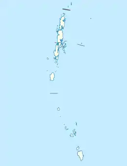
Nancowry Island
Nancowry (Nancowry language: Mūöt, Hindi: Nankovrī) is an island in the central part of the Nicobar Islands chain, located in the northeast Indian Ocean between the Bay of Bengal and the Andaman Sea.
| Native name: Nickname: Nankovri | |
|---|---|
 Nancowry Island 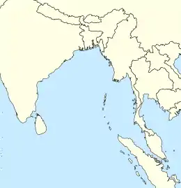 Nancowry Island | |
| Geography | |
| Location | Bay of Bengal |
| Coordinates | 7.98°N 93.55°E |
| Archipelago | Nicobar Islands |
| Adjacent bodies of water | Indian Ocean |
| Total islands | 1 |
| Major islands |
|
| Area | 47 km2 (18 sq mi)[1] |
| Length | 11.2 km (6.96 mi) |
| Width | 7.5 km (4.66 mi) |
| Coastline | 47 km (29.2 mi) |
| Highest elevation | 162 m (531 ft) |
| Administration | |
| District | Nicobar |
| Island group | Nicobar Islands |
| Subdivisions of India | Nancowry Subdivision |
| Taluk | Nancowry tehsil |
| Largest settlement | Mayo (Malacca) Point (pop. 516) |
| Demographics | |
| Population | 1019 (2011) |
| Pop. density | 21.7/km2 (56.2/sq mi) |
| Ethnic groups | Hindu, Nicobarese |
| Additional information | |
| Time zone |
|
| PIN | 744301 |
| Telephone code | 03192 |
| ISO code | IN-AN-00[2] |
| Official website | www |
| Literacy | 84.4% |
| Avg. summer temperature | 32.0 °C (89.6 °F) |
| Avg. winter temperature | 28.0 °C (82.4 °F) |
| Sex ratio | ♂/♀ |
| Census Code | 35.638.0002 |
| Official Languages | Hindi, English, Tamil Nancowry (regional) |
History
In 1755, the government of Denmark formally claimed sovereignty over Nicobars, under the name of Frederiksøerne ("Frederik Islands") and encouraged a mission established by the Moravian Brethren of Herrnhut. The Danes established a short-lived colony on the island which they named Ny Sjælland ("New Zealand").[3]
Along with Kamorta Island, which lies just to the north, Nancowry Island forms the "magnificent land-locked" Nancowry Harbour,[4] used by European sailors since at least the 17th century and described as "one of the safest natural harbours in the world" (). The harbour was apparently used as a base for piracy; in 1868, the British Navy entered the harbour in some force, destroying suspected pirate ships.[5][6][7]
2004 tsunami
The island, like many others in the Nicobar and Andaman islands, was severely affected by tsunamis generated by the 2004 Indian Ocean earthquake. According to reports from the Andaman and Nicobar Inspector General of Police, S.B. Deol, the Nancowry group of islands were among the worst-hit islands in the chain, with thousands missing and presumed dead.[8] Post-tsunami satellite photos,[9][10] and government situation reports indicate that while portions of Nancowry Island were affected, the adjoining islands of Katchall and Kamorta were more severely overrun. As of January 18, 2005, the government reported only 1 dead and 3 missing from Nancowry island, but 51 dead and 387 missing from Kamorta, and 345 dead and 4310 missing from Katchall.[11]
Demography
As of the 2011 Indian census, there are 1019 persons living on Nancowry island.[12]
Geography
Nancowry Island has an area of 47 km², and located 160 km south-southeast of Car Nicobar, the northernmost Nicobar island. Nancowry, like the Nicobar islands generally, is under the sovereignty of the nation of India. It is also part of the Nicobar and Andaman Tribal Reserve Area, which bars non-native people from visiting or conducting business on the island without permission in hopes of preserving the threatened native communities that live there.[13]
Climate
| Climate data for Nancowry Island (1981–2010, extremes 1952–2012) | |||||||||||||
|---|---|---|---|---|---|---|---|---|---|---|---|---|---|
| Month | Jan | Feb | Mar | Apr | May | Jun | Jul | Aug | Sep | Oct | Nov | Dec | Year |
| Record high °C (°F) | 34.4 (93.9) |
36.4 (97.5) |
35.6 (96.1) |
39.2 (102.6) |
38.6 (101.5) |
34.1 (93.4) |
32.7 (90.9) |
33.0 (91.4) |
34.7 (94.5) |
36.2 (97.2) |
34.1 (93.4) |
36.0 (96.8) |
39.2 (102.6) |
| Average high °C (°F) | 31.3 (88.3) |
31.9 (89.4) |
32.5 (90.5) |
32.8 (91.0) |
31.4 (88.5) |
30.5 (86.9) |
30.1 (86.2) |
30.0 (86.0) |
29.9 (85.8) |
30.2 (86.4) |
30.5 (86.9) |
30.9 (87.6) |
31.0 (87.8) |
| Average low °C (°F) | 24.2 (75.6) |
24.5 (76.1) |
24.7 (76.5) |
25.0 (77.0) |
24.7 (76.5) |
24.8 (76.6) |
24.6 (76.3) |
24.5 (76.1) |
24.1 (75.4) |
24.0 (75.2) |
24.0 (75.2) |
24.1 (75.4) |
24.4 (75.9) |
| Record low °C (°F) | 18.4 (65.1) |
19.0 (66.2) |
18.2 (64.8) |
19.6 (67.3) |
18.9 (66.0) |
19.2 (66.6) |
19.2 (66.6) |
19.0 (66.2) |
17.8 (64.0) |
18.6 (65.5) |
18.8 (65.8) |
18.7 (65.7) |
17.8 (64.0) |
| Average rainfall mm (inches) | 69.8 (2.75) |
52.8 (2.08) |
52.1 (2.05) |
98.3 (3.87) |
317.5 (12.50) |
242.1 (9.53) |
233.5 (9.19) |
208.3 (8.20) |
264.3 (10.41) |
276.2 (10.87) |
313.0 (12.32) |
193.4 (7.61) |
2,321.3 (91.39) |
| Average rainy days | 4.5 | 3.0 | 3.2 | 6.2 | 14.3 | 12.7 | 13.3 | 12.5 | 14.3 | 14.3 | 14.5 | 9.0 | 121.7 |
| Average relative humidity (%) (at 17:30 IST) | 80 | 79 | 78 | 79 | 84 | 84 | 84 | 84 | 86 | 86 | 86 | 82 | 83 |
| Source: India Meteorological Department[14][15] | |||||||||||||
Administration
The island belongs to the township of Nancowry of Nancowry tehsil.[16]
Image gallery
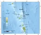 Map
Map Malacca village 1870
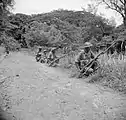 Rajput Regiment on patrol during World War II
References
- "Islandwise Area and Population – 2011 Census" (PDF). Government of Andaman. Archived from the original (PDF) on 2017-08-28. Retrieved 2016-05-03.
- Registration Plate Numbers added to ISO Code
- https://books.google.com/books?id=cL5mAAAAcAAJ&dq=%22Ny+Sj%C3%A6lland%22+%22Nancowry%22&pg=PA31&redir_esc=y#v=onepage&q=%22Ny%20Sj%C3%A6lland%22%20%22Nancowry%22&f=false
- Temple, Richard Carnac (1911). . In Chisholm, Hugh (ed.). Encyclopædia Britannica. 19 (11th ed.). Cambridge University Press. p. 661.
- Saini, Ajay (7 January 2018). "The pirates of Nicobar". The Hindu. Retrieved 19 October 2018.
- "Archived copy". Archived from the original on 2004-06-10. Retrieved 2004-12-31.CS1 maint: archived copy as title (link)
- "Archived copy". Archived from the original on 2007-03-11. Retrieved 2004-12-30.CS1 maint: archived copy as title (link)
- "Archived copy". Archived from the original on 2005-01-26. Retrieved 2005-01-26.CS1 maint: archived copy as title (link)
- "Archived copy". Archived from the original on 2004-12-17. Retrieved 2004-12-30.CS1 maint: archived copy as title (link)
- "Archived copy". Archived from the original on 2005-01-04. Retrieved 2004-12-30.CS1 maint: archived copy as title (link)
- "Station: Nancowry Climatological Table 1981–2010" (PDF). Climatological Normals 1981–2010. India Meteorological Department. January 2015. pp. 533–534. Archived from the original (PDF) on 5 February 2020. Retrieved 10 February 2020.
- "Extremes of Temperature & Rainfall for Indian Stations (Up to 2012)" (PDF). India Meteorological Department. December 2016. p. M3. Archived from the original (PDF) on 5 February 2020. Retrieved 10 February 2020.
- "Tehsils" (PDF). Archived from the original (PDF) on 2017-08-28. Retrieved 2016-05-03.
- Space Shuttle Photo of Nancowry and surrounding islands (courtesy Earth Sciences and Image Analysis, NASA-Johnson Space Center). Nancowry is the island on the bottom right. Adjoining it, with Nancowry Harbour between, is Camorta (Kamorta) Is. to the north (up) and Katchall Is. to the west (left).
- Government of the Andaman and Nicobar Union Territory (tsunami damage page)
- Andaman and Nicobar Police
- "Nicobar Islands rain forests". Terrestrial Ecoregions. World Wildlife Fund.
- M.V.R. Murti, et al., Evaluation of Coral Systems through Remote Sensing – A case study in Nicobar Islands, India, presented at Poster Session 2, ACRS 1991. Includes various close-up line maps of the Nancowry group.
- Before-and-after satellite photos of Katchall island
 Andaman and Nicobar Islands travel guide from Wikivoyage