Nantan, Kyoto
Nantan (南丹市, Nantan-shi) is a city located in Kyoto Prefecture, Japan.
Nantan
南丹市 | |||||||||||||
|---|---|---|---|---|---|---|---|---|---|---|---|---|---|
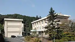 Nantan City hall | |||||||||||||
 Flag  Chapter | |||||||||||||
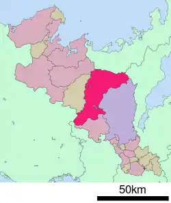 Location of Nantan in Kyoto Prefecture | |||||||||||||
 Nantan Location in Japan | |||||||||||||
| Coordinates: 35°6′N 135°28′E | |||||||||||||
| Country | Japan | ||||||||||||
| Region | Kansai | ||||||||||||
| Prefecture | Kyoto Prefecture | ||||||||||||
| Government | |||||||||||||
| • Mayor | Toshinori Sasaki (since April 2006) | ||||||||||||
| Area | |||||||||||||
| • Total | 616.40 km2 (237.99 sq mi) | ||||||||||||
| Population (October 1, 2017) | |||||||||||||
| • Total | 32,540 | ||||||||||||
| • Density | 53/km2 (140/sq mi) | ||||||||||||
| Time zone | UTC+09:00 (JST) | ||||||||||||
| Website | www | ||||||||||||
| |||||||||||||
As of October 1, 2017, the city has an estimated population of 32,540 and a population density of 53 persons per km². The total area is 616.40 km².
The modern city of Nantan was established on January 1, 2006, from the merger of the towns of Hiyoshi, Sonobe and Yagi (all from Funai District), and the town of Miyama (from Kitakuwada District). The name of Nantan stands for "southern Tanba".
Sights include the Rurikei Prefectural Natural Park and Miyama Kayabuki no sato "Thatched farmhouses village".
Famous people from Nantan
- Shigeru Miyamoto – video game designer
- Bonnie Pink – singer-songwriter
- Makoto Fujita – actor
- Hiromu Nonaka – politician
- Yoshimi Tanaka – politician
- Yasuhiro Nakagawa – politician
Sister cities
 Manila, Philippines[1]
 Clutha District, New Zealand[1]
References
- "Sister cities, towns and villages of Kyoto Prefecture". Kyoto Prefecture Website. Retrieved 5 February 2015.
External links
 Media related to Nantan, Kyoto at Wikimedia Commons
- Nantan City official website (in Japanese) (some English)
| Authority control |
|---|
This article is issued from Wikipedia. The text is licensed under Creative Commons - Attribution - Sharealike. Additional terms may apply for the media files.