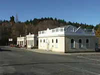
Naseby, New Zealand
Naseby is a small town, formerly a borough, in the Maniototo area of Central Otago, New Zealand. It is named after a village in Northamptonshire, England. Previous names of the township were Parker's, Hogburn and Mt Ida.[1] The town catch phrase is "2000 feet above worry level" indicating its altitude. [2] Naseby is 395 km (5 hours drive) from Christchurch and 143 km (1 hour 45 minutes drive) from Dunedin.


An important township during the gold rush of the 1860s, Gold was discovered in the Hogburn in 1863.[3] Much of the town has been preserved from this time and has something of the air of a working museum. At its peak, the population of the town was around 4,000 miners. Eighteen stores, 14 hotels, two butchers and a hospital had also been built to service the miners.[3] In 1898, a railway line was constructed 12 km away in Ranfurly and as a result services gradually moving away from Naseby to Ranfurly. By the time administrative boundaries were changed in the 1980s, it had become New Zealand's smallest borough, with a population of only around 100. The Population swells to around 3000 during the summer holiday season. [2] The nearest town, Ranfurly, lies 15 kilometres away.
Winters in Naseby are very harsh for New Zealand with a mean average high temperature of 6 degrees Celsius and a mean average low temperature of 0 degrees Celsius in July. [4]
Naseby is one of New Zealand's principal curling venues. The town also has an ice rink and New Zealand's only ice luge track (360m long).[5]
Since 1900 Douglas fir, Larch, and Corsican pine have been planted on the former gold fields and these mature trees form the Naseby forest. Mountain biking is very popular in the forest with 52 km of tracks present. A swimming dam just above the township is a popular spot in summer and often freezes over in winter.[6] Walking is also popular in the Naseby forest
The Mount Ida Water Race was built beginning in 1873. The water originates from the Manuherikia River. It winds its way along the Hawkdun Range, and collects water running off the streams as it flows towards Naseby. It was originally designed to feed the gold sluices. It now provides much needed irrigation to farmers in the upper Maniototo area. A track follows the course of the race through the forest and provides pleasant mountain biking and walking opportunities.[7]
Notes
- "Untitled". University of Otago. Retrieved 25 June 2012.
- "Naseby: Why this tiny Central Otago town is one of NZ's best holiday spots for kids". Stuff. 22 September 2016. Retrieved 17 September 2020.
- "Naseby history". www.nasebyinfo.org.nz. Retrieved 17 September 2020.
- "Climate Naseby". meteoblue. Retrieved 17 September 2020.
- NZOLA..........Naseby Ice Luge
- "Naseby Forest Mountain Bike Trails". Central Otago. Retrieved 17 September 2020.
- "Naseby Forest Walks". Central Otago. Retrieved 17 September 2020.