Cromwell, New Zealand
Cromwell (Māori: Tīrau) is a town in Central Otago in the Otago region of New Zealand.
Cromwell
Tīrau (Māori) | |
|---|---|
Town | |
 | |
 Cromwell | |
| Coordinates: 45.04°S 169.20°E | |
| Country | New Zealand |
| Region | Otago region |
| Territorial authority | Central Otago District Council |
| Population (June 2020)[1] | |
| • Total | 6,480 |
| Time zone | UTC+12 (NZST) |
| • Summer (DST) | UTC+13 (NZDT) |
| Postcode(s) | 9310 |
| Local iwi | Ngāi Tahu |
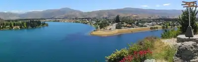
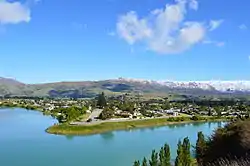
Cromwell is between State Highway 6 (linking to Wanaka, 50 kilometres (31 mi) north, and Queenstown, 60 kilometres (37 mi) west) and State Highway 8 leading to the Lindis Pass, 75 kilometres (47 mi) northeast, and Alexandra, 33 km south. The road to Alexandra winds through the Cromwell Gorge. A point near Cromwell lies 119 kilometres from the sea, the farthest from the sea anywhere in New Zealand.[2] A prominent feature surrounding much of the town is the man-made Lake Dunstan. Cromwell also has the newly constructed Highlands Motorsport Park. Nearby settlements are at Bannockburn, Lowburn, Tarras, and Ripponvale.
Cromwell is also the home of the Cromwell Chafer Beetle (Prodontria lewisi).
The 45th parallel south runs just north of the township.
History
Cromwell was originally known as "The Junction", being at the confluence of the Clutha / Mata-Au and Kawarau Rivers. In 1862, gold was discovered below the Junction by two miners, Hartley and Reilly. Once the word of a gold strike was out, there was an influx of several thousand miners to the area. Its newspaper, The Cromwell Argus, was established in 1869.[3]
As gold ran out, Cromwell became the service centre for an extensive farming and stone fruit growing area. It has a strategic location between the Lindis and the Haast passes, and acts as a hub between the towns of Wanaka, Queenstown and Alexandra. The former is commemorated with the giant sculpture of stone fruit which stands outside the northern end of the town.
Cromwell lay at the confluence of the [[Clutha River / Mata-Au and Kawarau River, which was noted for the difference between the colours of the waters of the two rivers and also for the historic bridge at the convergence of the two. Since the construction of the Clyde Dam and the filling of Lake Dunstan in the early 1990s the river confluence was drowned, as was the old town centre.
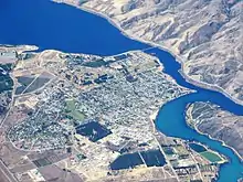
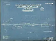
The decision to build Clyde Dam and use Cromwell as the accommodation base brought many changes to the town. Approximately one-third of the town was rebuilt on higher ground. The changes included the doubling of the residential area, relocation of the old town centre (now called "Old Cromwell Town"), upgrading of services, and the provision of modern educational and sports facilities, and a new bridge. The relocated town centre, or "The Mall," now houses the main retail, service and civic buildings in Cromwell. Several of the old buildings of the town which escaped the flooding have been retained as a historic precinct close to the shore of the Kawarau.
The town was named after Oliver Cromwell and, as well as "The Junction", the town was previously known as "The Point" and "Kawarau".
Cromwell is nicknamed the "Fruit Bowl of the South".
Climate
Cromwell receives around 400 mm of rain a year due to its inland location. Although it is widely believed to have a continental climate, the town officially has an oceanic climate (Cfb) with rainfall just enough to escape the semi-arid climate (Bsk) classification.
| Climate data for Cromwell | |||||||||||||
|---|---|---|---|---|---|---|---|---|---|---|---|---|---|
| Month | Jan | Feb | Mar | Apr | May | Jun | Jul | Aug | Sep | Oct | Nov | Dec | Year |
| Average high °C (°F) | 24.4 (75.9) |
24.2 (75.6) |
21.3 (70.3) |
17.3 (63.1) |
12.7 (54.9) |
8.7 (47.7) |
8.0 (46.4) |
11.4 (52.5) |
15 (59) |
17.6 (63.7) |
20.3 (68.5) |
22.5 (72.5) |
17.0 (62.6) |
| Daily mean °C (°F) | 17.7 (63.9) |
17.3 (63.1) |
14.6 (58.3) |
10.8 (51.4) |
7.2 (45.0) |
4.1 (39.4) |
3.2 (37.8) |
5.6 (42.1) |
8.9 (48.0) |
11.3 (52.3) |
13.7 (56.7) |
16.1 (61.0) |
10.9 (51.6) |
| Average low °C (°F) | 11 (52) |
10.4 (50.7) |
7.9 (46.2) |
4.2 (39.6) |
1.7 (35.1) |
−0.6 (30.9) |
−1.5 (29.3) |
−0.2 (31.6) |
2.8 (37.0) |
5.0 (41.0) |
7.1 (44.8) |
9.7 (49.5) |
4.8 (40.6) |
| Average precipitation mm (inches) | 48 (1.9) |
41 (1.6) |
38 (1.5) |
38 (1.5) |
28 (1.1) |
25 (1) |
23 (0.9) |
20 (0.8) |
28 (1.1) |
36 (1.4) |
30 (1.2) |
36 (1.4) |
390 (15.4) |
| Source: NIWA [4] | |||||||||||||
Demography
The Cromwell urban area had a usual resident population of 5,610 at the 2018 New Zealand census, an increase of 1,269 people (29.2%) since the 2013 census, and an increase of 1,866 people (49.8%) since the 2006 census. There were 2,898 males and 2,709 females, giving a sex ratio of 1.07 males per female. Of the total population, 1,044 people (18.6%) were aged up to 15 years, 909 (16.2%) were 15 to 29, 2,604 (46.4%) were 30 to 64, and 1,050 (18.7%) were 65 or older.[5]
Ethnicities were 90.1% European/Pākehā, 9.1% Māori, 2.0% Pacific peoples, 3.9% Asian, and 2.5% other ethnicities (totals add to more than 100% since people could identify with multiple ethnicities).[5]
| SA2 name | Population | Dwellings | Median age | Median income |
|---|---|---|---|---|
| Cromwell East | 2,562 | 1,287 | 41.7 years | $38,500 |
| Cromwell West | 3,048 | 1,416 | 39.0 years | $36,700 |
Cromwell mayors
Former mayors of the Borough of Cromwell were as follows
- WJ Barry 1866–1868
- W Whetter 1868–1869
- GW Goodger 1869–1870
- W Smitham 1870–1871
- JD Taylor 1871–1872
- M Fraer 1872–1873
- J Dawkins 1873–1874
- DA Jolly 1874–1877
- SN Brown 1877–1878
- C Colclough 1878–1881
- M Behrens 1881–1883
- J Marsh 1883–1885
- SH Turton 1885–1889
- T McCracken 1889–1891
- DA Jolly 1891–1892
- JL Scott 1892–1895
- T Rooney 1895–1897
- K Pretsch 1897–1899
- E Murrell 1899–1905
- J Little 1905–1909
- E Murrell 1905–1913
- E Jolly 1913–1915
- AM Brodrick 1915–1921
- DC Jolly 1921–1927
- CC Sanders 1927–1929
- CWJ Roberts 1929–1937
- JC Parcell 1937–1943
- RE Austin 1943–1944
- W Partridge 1944–1950
- James Robert Munro 1950–1951
- FG Dunn 1951–1956
- LR Skinner 1956–1958
- LA Jelley 1958–1960
- IG Anderson 1960–1980
- PJ Mead 1980–1986
- DA Butcher 1986–1989
Historic places
Bannockburn Bridge
The sign on the south side was reconstructed from the original suspension bridge's pillars.
Bannockburn
An historic town which was once the centre of a thriving and successful gold mining industry. Remnants include the hotel, Post Office, Stewart's store, and many old dwellings. Now a restful area centred on viticulture and agriculture.
The Bannockburn Sluicings
Walk through an incredible landscape changed by hand in the pursuit of gold. The round trip is full of history and interest.
Bendigo Goldfields
Bendigo was a successful quartz mining area for over half a century. From the site of the old Bendigo township at the top of the Bendigo Loop Road a steep, narrow vehicle track winds up into the hills to Logantown and even further up to Welshtown, where some of the most striking remains of old stone cottages can be found.
Carrick Goldfields
The ruins of Carricktown are 4 km up a 4WD track from the old mining area of Quartzville (near the end of Quartzville Road), and the Young Australian 6m overshot water-wheel can be found a further 3 km on. The track continues up to Duffer's Saddle. Return down Nevis Road to Bannockburn.
Cromwell Gorge
Hartley and Reilly first discovered gold at the beginning of this rugged and spectacular gorge.
Old Cromwell Town

The construction of the Clyde Dam created Lake Dunstan, which consumed part of the old Cromwell town. The deep river gorge, famed for its picturesque beauty, lined with orchards and vineyards, and especially the meeting point of two distinct rivers, was reformed with an artificially constructed shoreline. Though the original orchards were lost, Cromwell's climate has allowed it to maintain its reputation for wine and fruit production.
Education
Cromwell Primary School is a co-educational state primary school for Year 1 to 6 students,[7][8] with a roll of 336 as of March 2020.[9]
Goldfields School is a co-educational state primary school for Year 1 to 6 students,[10][11] with a roll of 270.[12]
Cromwell College is a co-educational state secondary school for Year 7 to 13 students,[13][14] with a roll of 520.[15]
Otago Polytechnic has a campus in Cromwell specialising in horticulture, catering and tourism. Its crop centre provides advisory services to horticulturalists on commercially viable new crops.[16]
References
- Notes
- "Population estimate tables - NZ.Stat". Statistics New Zealand. Retrieved 22 October 2020.
- Cook, Marjorie (11 February 2009). "Revealed: New Zealand's furthest inland point". Otago Daily times.
- Griffiths, George. "Fenwick, George". Dictionary of New Zealand Biography. Ministry for Culture and Heritage. Retrieved 8 January 2019.
- "Welcome to the Climate Database". NIWA. 2014. Retrieved on 22 March 2015.
- "Age and sex by ethnic group (grouped total response), for census usually resident population counts, 2006, 2013, and 2018 Censuses (urban rural areas)". nzdotstat.stats.govt.nz. Retrieved 13 September 2020.
- "2018 Census place summaries | Stats NZ". stats.govt.nz. Retrieved 14 December 2020.
- "Cromwell Primary School Official School Website". cromprimary.school.nz.
- "Cromwell Primary School Ministry of Education School Profile". educationcounts.govt.nz. Ministry of Education.
- "Cromwell Primary School Education Review Office Report". ero.govt.nz. Education Review Office.
- "Goldfields School Official School Website". goldfields.school.nz.
- "Goldfields School Ministry of Education School Profile". educationcounts.govt.nz. Ministry of Education.
- "Goldfields School Education Review Office Report". ero.govt.nz. Education Review Office.
- "Cromwell College Official School Website". cromwell.school.nz.
- "Cromwell College Ministry of Education School Profile". educationcounts.govt.nz. Ministry of Education.
- "Cromwell College Education Review Office Report". ero.govt.nz. Education Review Office.
- "Central Campus". op.ac.nz. Otago Polytechnic.
- Sources
- Reed, A.W. (2002) The Reed dictionary of New Zealand place names. Auckland: Reed Books. ISBN 0-790-00761-4.
- An Encyclopaedia of New Zealand, 1966, A. H. McLintock (editor)
External links
| Wikimedia Commons has media related to Cromwell, New Zealand. |
- Cromwell – promotional site