National Register of Historic Places listings in Shelby County, Alabama
This is a list of the National Register of Historic Places listings in Shelby County, Alabama.
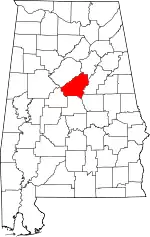
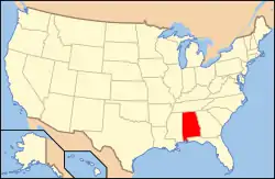
Location of Shelby County in Alabama
This is intended to be a complete list of the properties and districts on the National Register of Historic Places in Shelby County, Alabama, United States. Latitude and longitude coordinates are provided for many National Register properties and districts; these locations may be seen together in a Google map.[1]
There are 10 properties and districts listed on the National Register in the county.
- This National Park Service list is complete through NPS recent listings posted February 5, 2021.[2]
| [3] | Name on the Register | Image | Date listed[4] | Location | City or town | Description |
|---|---|---|---|---|---|---|
| 1 | Calera Downtown Historic District | 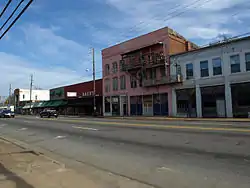 Calera Downtown Historic District |
March 29, 2006 (#06000188) |
Junction of U.S. Route 31 and State Route 25 33°06′01″N 86°45′09″W |
Calera | |
| 2 | Chancellor House | 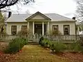 Chancellor House |
October 29, 2001 (#01001168) |
51 Chancellor Ferry Rd. 33°17′47″N 86°23′57″W |
Harpersville | |
| 3 | Columbiana City Hall | 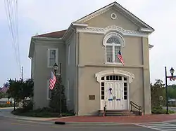 Columbiana City Hall |
October 29, 1974 (#74000437) |
107 Mildred St.[5] 33°10′38″N 86°36′26″W |
Columbiana | Also known as the Old Shelby County Courthouse |
| 4 | Downtown Montevallo Historic District |  Downtown Montevallo Historic District |
April 23, 2013 (#13000180) |
555-925 Main, 710-745 Middle & 608 Valley Sts. 33°06′03″N 86°51′46″W |
Montevallo | |
| 5 | Farrington Hall | 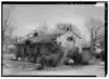 Farrington Hall |
July 21, 2015 (#15000434) |
124 Cty. Rd. 203 33°06′29″N 86°53′38″W |
Montevallo vicinity | |
| 6 | Helena Historic District | 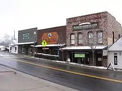 Helena Historic District |
April 18, 2006 (#06000278) |
Parts of State Route 261 and Helena Rd., parts of 1st-3rd Ave., and the 200 block of 3rd St. 33°17′45″N 86°50′41″W |
Helena | "Old Town" Helena during a rare snowfall in January 2008. These buildings date to the late 19th century. |
| 7 | King House |  King House |
January 14, 1972 (#72000179) |
University of Montevallo campus 33°06′18″N 86°51′47″W |
Montevallo | |
| 8 | McKibbon House | 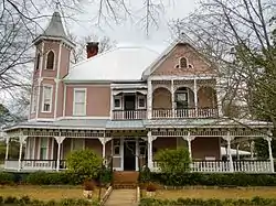 McKibbon House |
December 31, 2001 (#01001408) |
611 E. Boundary St. 33°05′51″N 86°51′42″W |
Montevallo | |
| 9 | Old Rock House | %252C_Harpersville_vicinity_(Shelby_County%252C_Alabama).jpg.webp) Old Rock House |
March 29, 2006 (#06000182) |
1 mile southeast of Harpersville at the end of a farm lane on the northern side of U.S. Route 280 33°19′49″N 86°24′27″W |
Harpersville | |
| 10 | University of Montevallo Historic District | .jpg.webp) University of Montevallo Historic District |
December 11, 1978 (#78000509) |
Bounded by Middle Campus Dr., Oak, Bloch and Middle Sts.; also roughly bounded by Bloch St., Farmer St., Flowerhill Dr., King St., Valley St., and Middle St. 33°06′10″N 86°51′57″W |
Montevallo | Originally listed in 1978 as Alabama Girls' Industrial School, expanded and renamed University of Montevallo Historic District in 1990. |
See also
| Wikimedia Commons has media related to National Register of Historic Places in Shelby County, Alabama. |
References
- The latitude and longitude information provided in this table was derived originally from the National Register Information System, which has been found to be fairly accurate for about 99% of listings. Some locations in this table may have been corrected to current GPS standards.
- "National Register of Historic Places: Weekly List Actions". National Park Service, United States Department of the Interior. Retrieved on February 5, 2021.
- Numbers represent an alphabetical ordering by significant words. Various colorings, defined here, differentiate National Historic Landmarks and historic districts from other NRHP buildings, structures, sites or objects.
- The eight-digit number below each date is the number assigned to each location in the National Register Information System database, which can be viewed by clicking the number.
- Location derived from this city website; the NRIS lists it as "Main St."
Municipalities and communities of Shelby County, Alabama, United States | ||
|---|---|---|
| Cities | Map of Alabama highlighting Shelby County | |
| Towns | ||
| CDPs | ||
| Unincorporated communities | ||
| Footnotes | ‡This populated place also has portions in an adjacent county or counties | |
| ||
This article is issued from Wikipedia. The text is licensed under Creative Commons - Attribution - Sharealike. Additional terms may apply for the media files.