Needle Mountain
Needle Mountain is a 6,620-foot (2,020-meter) elevation summit located in Capitol Reef National Park, in Wayne County of Utah, United States.[2] This remote erosional remnant is situated 16 miles (26 km) north-northwest of the park's visitor center, and 0.6 mile (1 km) east of Cathedral Mountain, in the Middle Desert of the park's North (Cathedral Valley) District. Cathedral Valley was so named in 1945 by Charles Kelly, first superintendent of Capitol Reef National Monument, because the valley's sandstone monoliths reminded early explorers of ornate, Gothic cathedrals, with fluted walls, alcoves, and pinnacles.[3] The free-standing Needle Mountain towers 240 feet (73 meters) above its surrounding terrain, which is within the Fremont River drainage basin. John C. Frémont's 1853 expedition passed through Cathedral Valley.[4]
| Needle Mountain | |
|---|---|
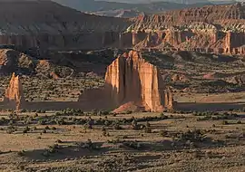 South aspect at sunset | |
| Highest point | |
| Elevation | 6,620 ft (2,020 m) [1] |
| Prominence | 240 ft (73 m) [1] |
| Parent peak | Cathedral Mountain (6,924 ft)[1] |
| Isolation | 0.60 mi (0.97 km) [1] |
| Coordinates | 38°29′26″N 111°21′22″W [2] |
| Geography | |
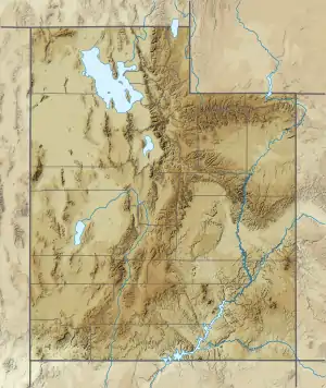 Needle Mountain Location in Utah  Needle Mountain Needle Mountain (the United States) | |
| Location | Capitol Reef National Park Wayne County, Utah, US |
| Parent range | Colorado Plateau |
| Topo map | USGS Cathedral Mountain |
| Geology | |
| Age of rock | Jurassic |
| Type of rock | Entrada Sandstone |
Geology
Needle Mountain is composed of unfractured Entrada Sandstone which was originally deposited as sandy mud on a tidal flat and is believed to have formed about 160 million years ago during the Jurassic period as a giant sand sea, the largest in Earth's history.[5][6] Stratum in Cathedral Valley have a gentle inclination of three to five degrees to the east, and appear nearly horizontal. Long after these sedimentary rocks were deposited, the Colorado Plateau was uplifted relatively evenly, keeping the layers roughly horizontal, but Capitol Reef is an exception because of the Waterpocket Fold, a classic monocline, which formed between 50 and 70 million years ago during the Laramide Orogeny.[7]
Gallery
 Cathedral Mountain (left), Needle Mountain (right), from the southeast
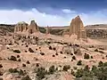 Cathedral Mountain (left), Needle Mountain (right)
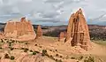
 "The Cathedrals" with Needle Mountain to right
.jpg.webp) Needle Mountain left of center
Needle Mountain left of center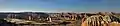 Cathedral Valley sunset, with Needle Mountain left of center
Climate
Spring and fall are the most favorable seasons to visit Needle Mountain. According to the Köppen climate classification system, it is located in a Cold semi-arid climate zone, which is defined by the coldest month having an average mean temperature below 32 °F (0 °C), and at least 50% of the total annual precipitation being received during the spring and summer. This desert climate receives less than 10 inches (250 millimeters) of annual rainfall, and snowfall is generally light during the winter.
| Climate data for Capitol Reef Visitor Center, elevation 5,653 ft (1,723 m), 1981-2010 normals, extremes 1981-2019 | |||||||||||||
|---|---|---|---|---|---|---|---|---|---|---|---|---|---|
| Month | Jan | Feb | Mar | Apr | May | Jun | Jul | Aug | Sep | Oct | Nov | Dec | Year |
| Record high °F (°C) | 58.6 (14.8) |
68.3 (20.2) |
78.3 (25.7) |
84.4 (29.1) |
94.6 (34.8) |
100.2 (37.9) |
100.8 (38.2) |
97.9 (36.6) |
95.4 (35.2) |
86.1 (30.1) |
70.4 (21.3) |
61.5 (16.4) |
100.8 (38.2) |
| Average high °F (°C) | 40.6 (4.8) |
46.4 (8.0) |
54.7 (12.6) |
65.0 (18.3) |
74.5 (23.6) |
85.3 (29.6) |
90.4 (32.4) |
87.9 (31.1) |
80.2 (26.8) |
66.1 (18.9) |
51.3 (10.7) |
40.6 (4.8) |
65.3 (18.5) |
| Average low °F (°C) | 17.8 (−7.9) |
22.7 (−5.2) |
30.2 (−1.0) |
36.2 (2.3) |
44.7 (7.1) |
53.1 (11.7) |
60.4 (15.8) |
58.5 (14.7) |
50.4 (10.2) |
39.0 (3.9) |
27.6 (−2.4) |
18.2 (−7.7) |
38.3 (3.5) |
| Record low °F (°C) | −4.2 (−20.1) |
−11.8 (−24.3) |
9.1 (−12.7) |
18.1 (−7.7) |
27.2 (−2.7) |
34.6 (1.4) |
42.4 (5.8) |
45.1 (7.3) |
29.9 (−1.2) |
11.7 (−11.3) |
8.0 (−13.3) |
−7.5 (−21.9) |
−11.8 (−24.3) |
| Average precipitation inches (mm) | 0.52 (13) |
0.34 (8.6) |
0.53 (13) |
0.47 (12) |
0.59 (15) |
0.47 (12) |
0.91 (23) |
1.20 (30) |
0.80 (20) |
0.98 (25) |
0.49 (12) |
0.32 (8.1) |
7.62 (194) |
| Average dew point °F (°C) | 17.3 (−8.2) |
20.8 (−6.2) |
23.0 (−5.0) |
24.5 (−4.2) |
29.1 (−1.6) |
32.0 (0.0) |
40.0 (4.4) |
41.8 (5.4) |
34.8 (1.6) |
28.2 (−2.1) |
21.9 (−5.6) |
17.5 (−8.1) |
27.6 (−2.4) |
| Source: PRISM[8] | |||||||||||||
See also
References
- "Needle Mountain - 6,620' UT". listsofjohn.com. Retrieved 2020-10-29.
- U.S. Geological Survey Geographic Names Information System: Needle Mountain
- North (Cathedral Valley) District, National Park Service
- Peter Massey, Jeanne Wilson, Utah Trails Central Region, 2006, Adler Publishing Company, page 106.
- Capitol Reef National Park, National Park Service
- North (Cathedral Valley) District, National Park Service
- Capitol Reef Geology, NPS.gov
- "PRISM Climate Group, Oregon State University". Retrieved February 19, 2019.
External links
- Capitol Reef National Park National Park Service
- Weather Forecast: Needle Mountain
