Neill Island
Shaheed Dweep, formerly known as Neill Island, is an island of the Andaman Islands, located in Ritchie's Archipelago. It belongs to the South Andaman administrative district, part of the Indian union territory of Andaman and Nicobar Islands.[6] the island lies 36 km (22 mi) northeast from Port Blair.
 Shaheed Island  Shaheed Island | |
| Geography | |
|---|---|
| Location | Bay of Bengal |
| Coordinates | 11.83°N 93.04°E |
| Archipelago | Andaman Islands |
| Adjacent bodies of water | Indian Ocean |
| Area | 13.7 km2 (5.3 sq mi)[1] |
| Length | 3.7 km (2.3 mi) |
| Width | 6.3 km (3.91 mi) |
| Coastline | 19.4 km (12.05 mi) |
| Highest elevation | 101 m (331 ft)[2] |
| Highest point | Nipple Hill |
| Administration | |
| District | South Andaman |
| Island group | Andaman Islands |
| Island sub-group | Ritchie's Archipelago |
| Tehsil | Port Blair Tehsil |
| Largest settlement | Neill Kendra (pop. 1000) |
| Demographics | |
| Population | 3040 (in 2011) |
| Pop. density | 222.00/km2 (574.98/sq mi) |
| Ethnic groups | Hindu, Andamanese |
| Additional information | |
| Time zone |
|
| PIN | 744104[3] |
| Telephone code | 031927[4] |
| ISO code | IN-AN-00[5] |
| Official website | www |
| Literacy | 84.4% |
| Avg. summer temperature | 30.2 °C (86.4 °F) |
| Avg. winter temperature | 23.0 °C (73.4 °F) |
| Sex ratio | 1.2♂/♀ |
| Census code | 35.639.0004 |
| Official languages | Hindi, English |
Etymology
Neill Island is named after British Brigadier general James Neill, who had fought on the side of the British East Indian company in the Sepoy Mutiny of 1857.
In December 2018, it was renamed as Shaheed Dweep as a tribute to Subhas Chandra Bose. Bose had hoisted the Indian flag at Port Blair on 30 December 1943 and proclaimed the Andaman and Nicobar Islands as territories liberated form British rule. He had subsequently named Andaman Island as Shaheed and Nicobar Island as Swaraj.[7]
History
Neill Island was uninhabited until the arrival of settlers in the late 1960s. Like Havelock, the vast majority of settlers at Neill were refugees from erstwhile East-Pakistan, following the exodus of Hindu Bangladeshis prior to that country's war of independence in 1971.
On 30 December 2018, Prime Minister Narendra Modi announced that Neill Island would be renamed as Shaheed Dweep.[8]
Geography
The island belongs to the Ritchie's Archipelago and is located between Havelock Island and Rose Island. It is a comparatively flat island, and much of the landmass was deemed suitable for paddy cultivation. Unfortunately, as a result of this, very little forest cover remains at Neil, and almost all of it is concentrated in the reserve forest on Neil's north-western side. Neill island tends to remain a degree or two warmer than Havelock as a result of the lack of forest cover. The island is not without charm however, but it is a different, pastoral sort of charm that the island offers.
Administration
Politically, Neill Island is part of Neill Kendra panchayat, of Port Blair Taluk.[9]
Demographics
The population of 3040 lives in five villages, listed below, with population at 2011 census in parentheses:[10]
- Sitapur (274)
- Bharatpur (629)
- Neill Kendra (1000)
- Lakshmanpur (382)
- Ram Nagar (755)
Transport
There is a jetty at Neill Kendra, which serves as the only access point of the island.[11] There are regular Government ferry from Port Blair to Neill Island. There are private cruise ships such as Makruzz and Coastal Cruise.[12]
Economy
Agriculture is the primary occupation of the villagers, and the island supplies vegetables to the rest of Andaman.
Tourism
Despite its minuscule tourist infrastructure, an increasing number of tourists have chosen to stay at Neill Island instead of neighboring Havelock Island. There are a handful of restaurants and basic beach hotels that cater to international and domestic tourists.
Some notable places to visit in Neil Island are, Bharatpur Beach, Laxmanpur Beach, Sitapur Beach, and Natural Bridge. Some people also like to visit the Ramnagar Beach, also known as the Sunset Beach. Water Sports Activities are only available in Bharatpur Beach. Rest of the attractions are only for sightseeing. [13]
Image gallery
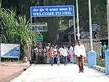 Entry to Neill Island from Bharatpur Jetty.
 Hawrah Natural Bridge, Neill Island.
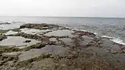 Coral Reef
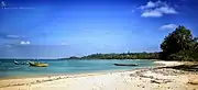 Neill Island
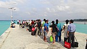 Bharathpur Jetty
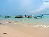 Bharatpur Beach
 Landscape
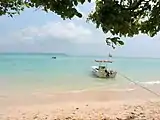 Bharatpur beach
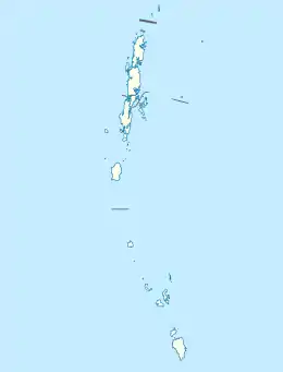
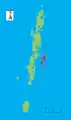 Ritchie's Archipelago within the Andaman Islands
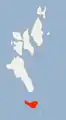 Neill Island within Ritchie's Archipelago
References
| Wikivoyage has a travel guide for Neil Island. |
- "Islandwise Area and Population - 2011 Census" (PDF). Government of Andaman. Archived from the original (PDF) on 28 August 2017. Retrieved 10 October 2016.
- Sailing Directions (Enroute), Pub. 173: India and the Bay of Bengal (PDF). Sailing Directions. United States National Geospatial-Intelligence Agency. 2017. p. 284.
- "A&N Islands - Pincodes". 22 September 2016. Archived from the original on 23 March 2014. Retrieved 22 September 2016.CS1 maint: bot: original URL status unknown (link)
- "STD Codes of Andaman and Nicobar". allcodesindia.in. Retrieved 23 September 2016.
- Registration Plate Numbers added to ISO Code
- "Village Code Directory: Andaman & Nicobar Islands" (PDF). Census of India. Retrieved 16 January 2011.
- Ananya Bhardwaj (25 December 2018). "Andaman's most-visited islands to be renamed during PM Modi visit". Hindustan Times. Retrieved 31 December 2018.
- "PM Narendra Modi renames 3 islands of Andaman Nicobar". The Times of India. 30 December 2018. Retrieved 31 December 2018.
- "DEMOGRAPHIC – A&N ISLANDS" (PDF). andssw1.and.nic.in. Archived from the original (PDF) on 28 August 2017. Retrieved 23 September 2016.
- "Census of India: Sub-District Details".
- "Neil Island in Andaman and Nicobar, About Neil Island in Andaman". 20 May 2013. Archived from the original on 20 May 2013.CS1 maint: bot: original URL status unknown (link)
- Experience Andaman. "Ferry in Andaman Service, Timings and Tickets - Experience Andamans".
- "Neil Island Travel Guide- Worth Visiting? | Attractions, Hotels, Things to do, and Transfers". www.eternalandamans.com. Retrieved 22 January 2020.
External links
![]() Media related to Neil Island at Wikimedia Commons
Media related to Neil Island at Wikimedia Commons