Nevada State Route 647
State Route 647 (SR 647) is a state highway in Washoe County, Nevada. The route currently comprises a portion of West Fourth Street in Reno and a short segment of Prater Way in Sparks. The route previously extended a greater distance east–west through Reno–Sparks, and was formerly designated as part of U.S. Route 40.
_in_Reno%252C_Nevada.jpg.webp)
View west along SR 647
| ||||
|---|---|---|---|---|
| W. Fourth Street / Prater Way / Victorian Avenue | ||||
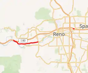
SR 647 highlighted in red | ||||
| Route information | ||||
| Length | 3.397 mi[1] (5.467 km) | |||
| Existed | 1976–present | |||
| Major junctions | ||||
| West end | ||||
| East end | ||||
| Location | ||||
| Counties | Washoe | |||
| Highway system | ||||
| ||||


Major intersections
The entire route is in Washoe County.
| Location | mi | km | Destinations | Notes | |||
|---|---|---|---|---|---|---|---|
| Reno | 0 | 0.0 | Western terminus; I-80 exit 8 | ||||
| McCarran Boulevard (SR 659) | |||||||
| Gap in route | |||||||
| Reno–Sparks line | Galletti Way | ||||||
| Sparks | Eastern terminus; I-80 exit 16 | ||||||
| 1.000 mi = 1.609 km; 1.000 km = 0.621 mi | |||||||
See also
 United States portal
 U.S. Roads portal
References
- Nevada Department of Transportation (January 2017). "State Maintained Highways of Nevada: Descriptions and Maps". Retrieved 2017-01-28.
| Wikimedia Commons has media related to Nevada State Route 647. |
This article is issued from Wikipedia. The text is licensed under Creative Commons - Attribution - Sharealike. Additional terms may apply for the media files.
