New Hampshire Route 13
New Hampshire Route 13 is a 43.38-mile (69.81 km) long north–south state highway in the state of New Hampshire, United States. The highway runs from Brookline to Concord.
| ||||
|---|---|---|---|---|
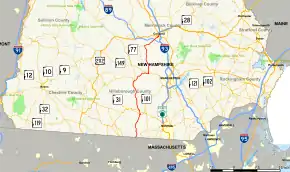 Map of southern New Hampshire with NH 13 highlighted in red | ||||
| Route information | ||||
| Maintained by NHDOT | ||||
| Length | 43.368 mi[1] (69.794 km) | |||
| Major junctions | ||||
| South end | ||||
| North end | ||||
| Location | ||||
| Counties | Hillsborough, Merrimack | |||
| Highway system | ||||
| ||||

The southern terminus is at the Massachusetts state line in Brookline, where the route continues south as Massachusetts Route 13. The northern terminus is in the center of Concord at U.S. Route 202 and New Hampshire Route 9, locally the intersection of South Street and Pleasant Street.
Route description
Brookline to Milford
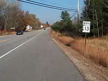
NH 13 begins as a continuation of Massachusetts Route 13 at the state line between Brookline and Townsend, Massachusetts. It continues north for about 8.4 miles (13.5 km) through Brookline and crosses into Milford, where it meets an interchange with New Hampshire Route 101. The highway continues north for about 1.4 miles (2.3 km) through the outskirts of Milford's urban center until it reaches Union Square, better known as the Milford Oval, where it intersects New Hampshire Route 101A.
Mont Vernon to Goffstown
NH 13 continues north over the Souhegan River on the Colonel John Shepard Bridge, then turns northwest for 4.4 miles (7.1 km) towards Mont Vernon and serves as the town's main road. After intersecting the Francestown Turnpike in the center of Mont Vernon, NH 13 continues northwest for about 5.9 miles (9.5 km) until it intersects New Hampshire Route 136 in the center of New Boston. The highway then turns east, crossing the South Branch Piscataquog River, then goes northeast for 6.4 miles (10.3 km) along the path of the river toward Goffstown. It turns north at the intersection of New Hampshire Route 114 with which it briefly runs concurrently over the Piscataquog River and into downtown Goffstown.
Dunbarton to Concord
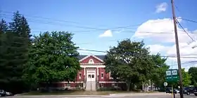
After separating from NH 114 at the Goffstown Public Library, NH 13 continues north for 6.1 miles (9.8 km) to the town center of Dunbarton, then for another 3.5 miles (5.6 km) north where it intersects New Hampshire Route 77. After taking a sharp right at the intersection, NH 13 heads northeast towards Concord for 4.0 miles (6.4 km) until it reaches the interchange with Interstate 89 near a New Hampshire State Police barracks. NH 13 then turns north on South Street near downtown Concord, where it meets its northern terminus at US 202/NH 9.
Junction list
| County | Location[1][2] | mi[1][2] | km | Destinations | Notes |
|---|---|---|---|---|---|
| Hillsborough | Brookline | 0.000 | 0.000 | Continuation from Massachusetts | |
| 3.385 | 5.448 | Western terminus of NH 130 | |||
| Milford | 8.391– 8.550 | 13.504– 13.760 | Interchange | ||
| 9.760 | 15.707 | Union Square (the "Milford Oval") | |||
| New Boston | 20.572 | 33.107 | Eastern terminus of NH 136 | ||
| Goffstown | 27.135 | 43.670 | Southern end of concurrency with NH 114 | ||
| 27.454 | 44.183 | Northern end of concurrency with NH 114 | |||
| Merrimack | Dunbarton | 37.072 | 59.662 | Northern terminus of NH 77 | |
| Concord | 40.889– 41.172 | 65.804– 66.260 | Exit 2 on I-89 | ||
| 43.368 | 69.794 | Northern terminus of NH 13 | |||
1.000 mi = 1.609 km; 1.000 km = 0.621 mi
| |||||
References
- Bureau of Planning & Community Assistance (February 20, 2015). "NH Public Roads". Concord, New Hampshire: New Hampshire Department of Transportation. Retrieved April 7, 2015.
- Bureau of Planning & Community Assistance (April 3, 2015). "Nodal Reference 2015, State of New Hampshire". New Hampshire Department of Transportation. Retrieved April 7, 2015.