New Ringgold, Pennsylvania
New Ringgold is a borough in Schuylkill County, Pennsylvania, United States. The population was 291 at the 2000 census.
New Ringgold, Pennsylvania | |
|---|---|
Borough | |
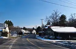 View of entrance of New Ringgold, Pennsylvania | |
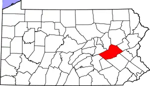
 Location of New Ringgold in Schuylkill County, Pennsylvania. | |
 New Ringgold Location in Pennsylvania  New Ringgold New Ringgold (the United States) | |
| Coordinates: 40°41′13″N 75°59′53″W | |
| Country | United States |
| State | Pennsylvania |
| County | Schuylkill |
| Settled | 1867 |
| Incorporated | 1877 |
| Government | |
| • Type | Borough Council |
| • Mayor | Al McGriggen |
| Area | |
| • Total | 0.80 sq mi (2.07 km2) |
| • Land | 0.80 sq mi (2.07 km2) |
| • Water | 0.00 sq mi (0.00 km2) |
| Population (2010) | |
| • Total | 276 |
| • Estimate (2019)[2] | 262 |
| • Density | 327.91/sq mi (126.62/km2) |
| Time zone | UTC-5 (Eastern (EST)) |
| • Summer (DST) | UTC-4 (EDT) |
| ZIP code | 17960 |
| Area code(s) | 570 and 272 (570 Exchange: 943) |
| FIPS code | 42-54016 |
ZIP Code 17960 serves the borough and portions of East Brunswick Township and West Penn Township. The town serves as a crossroad between Pennsylvania Route 895 and Pennsylvania Route 443. The crossroads create a minor problem for trucks turning onto PA 895, because there is no stop light and cars are not required to stop. The Reading Blue Mountain and Northern Railroad runs through the heart of the town.
Geography
New Ringgold is located at 40°41′13″N 75°59′53″W (40.686969, -75.998000).[3]
According to the United States Census Bureau, the borough has a total area of 0.9 square miles (2.3 km2), all of it land. The Little Schuylkill River flows southward through New Ringgold to meet the Schuylkill River in Port Clinton. The borough is served by Routes 443 and 895.
New Ringgold has a hot-summer humid continental climate (Dfa) and average monthly temperatures range from 27.7° F in January to 72.6° F in July. The hardiness zone is 6b.
Demographics
| Historical population | |||
|---|---|---|---|
| Census | Pop. | %± | |
| 1880 | 100 | — | |
| 1890 | 240 | 140.0% | |
| 1900 | 228 | −5.0% | |
| 1910 | 266 | 16.7% | |
| 1920 | 223 | −16.2% | |
| 1930 | 245 | 9.9% | |
| 1940 | 313 | 27.8% | |
| 1950 | 302 | −3.5% | |
| 1960 | 314 | 4.0% | |
| 1970 | 314 | 0.0% | |
| 1980 | 301 | −4.1% | |
| 1990 | 315 | 4.7% | |
| 2000 | 291 | −7.6% | |
| 2010 | 276 | −5.2% | |
| 2019 (est.) | 262 | [2] | −5.1% |
| Sources:[4][5][6] | |||
As of the census[5] of 2000, there were 291 people, 118 households, and 82 families residing in the borough. The population density was 340.4 people per square mile (132.2/km2). There were 128 housing units at an average density of 149.7 per square mile (58.1/km2). The racial makeup of the borough was 99.66% White and 0.34% African American. Hispanic or Latino of any race were 0.69% of the population.
There were 118 households, out of which 30.5% had children under the age of 18 living with them, 55.1% were married couples living together, 7.6% had a female householder with no husband present, and 30.5% were non-families. 25.4% of all households were made up of individuals, and 8.5% had someone living alone who was 65 years of age or older. The average household size was 2.47 and the average family size was 2.95.
In the borough the population was spread out, with 21.3% under the age of 18, 8.2% from 18 to 24, 31.3% from 25 to 44, 23.0% from 45 to 64, and 16.2% who were 65 years of age or older. The median age was 37 years. For every 100 females there were 90.2 males. For every 100 females age 18 and over, there were 92.4 males.
The median income for a household in the borough was $27,083, and the median income for a family was $32,250. Males had a median income of $31,500 versus $19,167 for females. The per capita income for the borough was $13,492. About 11.1% of families and 10.2% of the population were below the poverty line, including 13.6% of those under the age of eighteen and 7.0% of those 65 or over.
References
- "2019 U.S. Gazetteer Files". United States Census Bureau. Retrieved July 28, 2020.
- "Population and Housing Unit Estimates". United States Census Bureau. May 24, 2020. Retrieved May 27, 2020.
- "US Gazetteer files: 2010, 2000, and 1990". United States Census Bureau. 2011-02-12. Retrieved 2011-04-23.
- "Census of Population and Housing". U.S. Census Bureau. Retrieved 11 December 2013.
- "U.S. Census website". United States Census Bureau. Retrieved 2008-01-31.
- "Incorporated Places and Minor Civil Divisions Datasets: Subcounty Resident Population Estimates: April 1, 2010 to July 1, 2012". Population Estimates. U.S. Census Bureau. Archived from the original on 11 June 2013. Retrieved 11 December 2013.
| Wikimedia Commons has media related to New Ringgold, Pennsylvania. |