Niverville, Manitoba
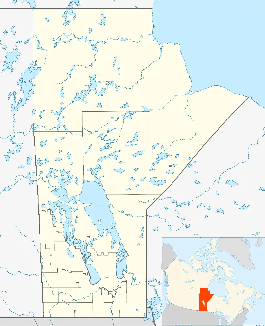
Niverville is a town in the Canadian province of Manitoba, located approximately 42 km (26 mi) south of downtown Winnipeg. This primarily farming community has seen an influx of people moving from the city looking to raise a family outside the 'big city' influence. This migration has made Niverville one of the youngest and fastest growing communities in Manitoba. The town is located at the crossing of Provincial Road 311 and the CPR Emerson rail line, between Provincial Road 200 and Provincial Trunk Highway 59. Niverville's population as at the 2016 Census is 4,083.[1] The town lies between the northwest corner of the Rural Municipality of Hanover and the southeastern portion of the Rural Municipality of Ritchot.
Niverville | |
|---|---|
| Motto(s): Where you belong | |
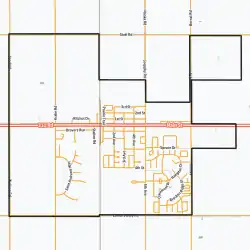 Town boundaries | |
 Niverville Location of Niverville | |
| Coordinates: 49°36′20″N 097°02′30″W | |
| Country | Canada |
| Province | Manitoba |
| Region | Eastman |
| Established | 1874 |
| Incorporated |
|
| Government | |
| • Mayor | Myron Dyck |
| • Governing Body | Town Council |
| • MP (Provencher) | Ted Falk |
| • MLA (Morris) | Shannon Martin |
| Area | |
| • Total | 2.31 km2 (0.89 sq mi) |
| Elevation | 236 m (774 ft) |
| Population (2016)[1] | |
| • Total | 4,083 |
| Time zone | UTC-6 (CST) |
| • Summer (DST) | UTC-5 (CDT) |
| Postal Code | R0A 1E0, R0A 0A1, & R0A 0A2 |
| Website | Official website |
History
The area of Niverville was first developed by railway tycoon Joseph Whitehead in 1874, who spent more than C$1,700 in its development as a station. However, the station was established not by Whitehead, but by William Hespeler, who was instrumental in recruiting Mennonite settlers from the Russian Empire settlers to the nearby East Reserve. Initially the town that grew up around the station was named Hespeler, but eventually became known by the name of the railway station, Niverville. The town is named after an 18th-century explorer and fur trader Chevalier Joseph-Claude Boucher de Niverville.[3] This choice of name was made by the Canadian Pacific Railway in 1877 – one year before the railway into town was built and an official town plan was actually registered. Originally within the Rural Municipality of Hanover, Niverville was incorporated as a village in 1969 and later as a town in 1993.
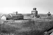
Niverville's history is closely tied to grain. Niverville is located on the western boundary and a mile south of the northern boundary of the eight townships of land reserved for Mennonite settlement in 1873. The influx of Mennonites, Low German-speaking farmers, began in 1874 and shortly after the CPR Emerson line was complete in 1878 they were joined by a number of settlers of British ancestry with names like Stott, Church, and Wallace who settled just west the rail line off the reserve. The Mennonite settlers, whose farming skills were well suited for the region due to their experience with farming on the Germanic low lands and Pontic steppes, came originally from Friesland, the northern region of the Netherlands (their place of origin), moving to the Vistula Delta in the 17th century, then the Russian Empire under the protection of Katherine the Great, before finally migrating and landing at the nearby junction of the Red and Rat rivers. Once landed they made their way onto the reserved lands to claim their individual homesteads. William Hespeler, the Dominion Immigration and Agriculture Agent for Manitoba, was the first to make an effort to establish a commercial centre on the reserve by purchasing land from individual farmers and laying out a town plan for Niverville. The first grain elevator in western Canada, a unique round structure was built in Niverville in 1879 by him. It was from this elevator that the first western Canadian barley was shipped to overseas markets. To commemorate his contributions his name has recently been appropriated for Niverville's newest and largest park. The hardiness and determination of the early Mennonite settlers, coming from a harsh environment in Russia, ensured that this unforgiving land would be transformed into a place from which livelihoods could be wrested, albeit at considerable effort and cost. In later years, these generous settlers sent grain in relief to others suffering famine in Russia. Many inhabitants today are from Mennonite or British stock, with a growing number of immigrants of other backgrounds.[1]
One odd piece of Niverville history is the Niverville Pop Festival which took place on May 24, 1970 on an abandoned farm 2.4 km (1.5 mi) east of the junction of Highway 59 and Provincial Road 305. Widely publicized, it attracted approximately 12,000 young folks, mainly from Winnipeg, to hear a variety of rock and folk bands. Having nowhere to park save a summer-fallowed field and some dirt roads, everything turned into a sea of mud when a sudden thunderstorm struck, cutting the festival short. Not wishing to lose the opportunity, many festival patrons shed all clothing (including underwear) and splashed around in the rain and mud while waiting for any one of several local Mennonite farmers who cashed in on the opportunity, charging $5 apiece to tow cars back to the pavement of Highway 59.[4]
Geography
The town lies in the Red River Valley.
Water
Niverville improved its Water Treatment Plant in 2012, expanding the reservoir to 1.2 megalitres.[5]
In June 2017, hot, dry weather caused higher water usage, and town notified residents to cut back on water usage because the reservoir could not be replenished quickly enough.[6] A new well field opened in 2017 to prevent future water shortages.[7]
Sociology
Education
Niverville schools are part of the Hanover School Division. Niverville Elementary School (K-4), Niverville Middle School (5-8), and Niverville High School (9-12) provide education for the students of Niverville and surrounding area. Niverville Collegiate Institute (NCI) formerly housed the middle and high schools until 2019, when the school division constructed a new high school for the town and NCI was converted into the present-day middle school. Niverville's high school athletic teams, the Panthers, have achieved success in volleyball, basketball, soccer, and badminton competitions, winning banners and trophies in tournaments and provincial championships since the late 1970s.
Recreation
Niverville has several recreational facilities, including the Niverville Centennial Arena, home of the Niverville Clippers, the Niverville Curling Club, an outdoor tennis court located at Niverville Collegiate, the Elite Fitness and Dance gym, Opa's Park, the fairgrounds (located behind the arena) which hosted the Heartland Rodeo Association finals in 2007, and Hespeler Park, which has a tobogganing hill, soccer pitches, baseball diamonds, a beach volleyball court, a small biking trail and a community splash pad. The Splash Pad is approximately 330 m2 (3,500 sq ft) and includes a washroom/change room and canteen building, and a maintenance & storage building. The Splash Pad features two areas of play: a toddler water play area for ages 0–3 and a family play area for ages 3–12. Water features are bright and colourful. The Splash Pad is fully accessible and inclusive for all ages and abilities. The Crow Wing Trail also runs through the town. The Good Times Hockey League is a six team recreational hockey league that plays out of the Niverville Arena. In addition, a 9-hole golf course just finished its first full year of being open on the western edge of town.
Six churches of various different Christian denominations serve the community and surrounding area.[8]
Niverville Fair
Niverville's signature event is the annual Niverville Olde Tyme Country Fair, which is held the second weekend of June. During the two-day event, Niverville's Main Street is shut down to traffic, and Midway rides, as well as food and a farmers market stands are set up. Various events, such as fireworks and a parade are also held. As the popularity of the fair grew, so has its budget, and today professional music acts such as Dean Brody, Gord Bamford and Chad Brownlee headline the fair. Entertainment has included world renowned acrobatics, extreme motocross and magicians.
Economy
There are several significant employers in Niverville, including The Great GORP Project (Food Industry), Spectis Moulders (polyurethane architectural products), Maple Leaf Foods (agribusiness), William Dyck and Sons (hardware store and lumberyard), Wiens Furniture (furniture, appliance and bedding retailer) and Niverville Credit Union. Other services include a grocery store, two full service gas stations and convenience stores, hair care, construction trades, several restaurants, medical and dental clinics, a pharmacy, accountants, insurance brokers, law offices, post office, and two car washes.
Several new developments including Fifth Avenue Estates, The Highlands, Stonecroft and Vista Cove have expanded the size and population of the town, helping to draw in many Winnipeggers and new immigrants to the area. Housing in Niverville ranges from several apartment buildings to semi-detached dwellings to single-unit housing. A small RCMP detachment and the volunteer Niverville Fire & EMS serve the area. Advanced medical care is available from several nearby hospitals in Steinbach, St. Pierre Jolys, and Winnipeg. The 3.4 ha (8.5 acres) Niverville Heritage Centre[9] provides space for various events including weddings, graduations, and Remembrance Day services. The addition of the Niverville Credit Union Manor provides assisted living and supportive care for seniors. An extensive network of pig barns in the surrounding area provide a source of revenue for the local agricultural community, unfortunately at the expense of the air quality of the community.
Government
The town is governed by a mayor and council elected by the residents. The current mayor is Myron Dyck. Niverville lies within the federal riding of Provencher; the current MP for this riding is Ted Falk. At the provincial level, the Niverville has been part of several different ridings as boundaries have changed over the years. Currently, Niverville is part of the Morris electoral district, represented by Shannon Martin.
Notable people
- Amanda Lindsey Cook, Christian recording artist[10]
- David Bergen, novelist
- William Hespeler, town founder
References
- "2016 Census Profile - Niverville". statcan.gc.ca. November 29, 2017. Retrieved December 25, 2019.
- "Elevation of Niverville". earthtools.org.
- "Reflections on our Heritage" (PDF). Derksen Printers Ltd. 1971. Retrieved 2016-10-03.
- Niverville Chamber of Commerce, "Niverville Area History".
- "Governments celebrate upgrades to Niverville's water treatment plant". news.gov.mb.ca. June 9, 2012. Retrieved February 13, 2020.
- "Niverville joins list of communities restricting water use amid hot, dry weather". CTV News Winnipeg. June 8, 2017. Retrieved February 13, 2020.
- "Niverville - Urgent Water Notice". www.whereyoubelong.ca. June 7, 2017. Retrieved February 13, 2020.
- Town of Niverville, "Town of Niverville".
- Noella. "History". Niverville Heritage Centre. Retrieved 2020-02-10.
- Amanda Falk, "Amanda Falk's Myspace Page".
External links
| Wikimedia Commons has media related to Niverville, Manitoba. |
Places adjacent to Niverville, Manitoba | ||||||||||
|---|---|---|---|---|---|---|---|---|---|---|
| ||||||||||
| Cities |  | ||
|---|---|---|---|
| Towns | |||
| Villages | |||
| Rural municipalities |
| ||
| First Nations | |||
| Indian reserves | |||
| Unincorporated communities | |||