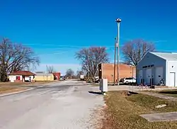
Nodaway, Iowa
Nodaway is a city in Nodaway Township, Adams County, Iowa, United States. The population was 114 at the 2010 census. Nodaway was incorporated in 1900.[4]
Nodaway, Iowa | |
|---|---|
 | |
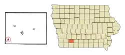 Location of Nodaway, Iowa | |
| Coordinates: 40°56′15″N 94°53′39″W | |
| Country | |
| State | |
| County | Adams |
| Township | Nodaway |
| Area | |
| • Total | 0.54 sq mi (1.39 km2) |
| • Land | 0.54 sq mi (1.39 km2) |
| • Water | 0.00 sq mi (0.00 km2) |
| Elevation | 1,083 ft (330 m) |
| Population | |
| • Total | 114 |
| • Estimate (2019)[3] | 103 |
| • Density | 192.52/sq mi (74.30/km2) |
| Time zone | UTC-6 (Central (CST)) |
| • Summer (DST) | UTC-5 (CDT) |
| ZIP code | 50857 |
| Area code(s) | 712 |
| FIPS code | 19-56865 |
| GNIS feature ID | 0459537 |
History
Nodaway was a shipping point on the Chicago, Burlington and Quincy Railroad.[5]
Geography
Nodaway is located at 40°56′15″N 94°53′39″W (40.937486, -94.894207).[6]
According to the United States Census Bureau, the city has a total area of 0.54 square miles (1.40 km2), all land.[7]
Demographics
| Year | Pop. | ±% |
|---|---|---|
| 1910 | 323 | — |
| 1920 | 340 | +5.3% |
| 1930 | 334 | −1.8% |
| 1940 | 270 | −19.2% |
| 1950 | 233 | −13.7% |
| 1960 | 204 | −12.4% |
| 1970 | 176 | −13.7% |
| 1980 | 185 | +5.1% |
| 1990 | 153 | −17.3% |
| 2000 | 132 | −13.7% |
| 2010 | 114 | −13.6% |
| 1880 | 108 | −5.3% |
| 2019 | 103 | −4.6% |
| Source:"U.S. Census website". United States Census Bureau. Retrieved 2020-03-29. and Iowa Data Center Source: | ||
2010 census
At the 2010 census there were 114 people in 47 households, including 31 families, in the city. The population density was 211.1 inhabitants per square mile (81.5/km2). There were 62 housing units at an average density of 114.8 per square mile (44.3/km2). The racial makup of the city was 98.2% White and 1.8% from two or more races.[2]
Of the 47 households 27.7% had children under the age of 18 living with them, 51.1% were married couples living together, 8.5% had a female householder with no husband present, 6.4% had a male householder with no wife present, and 34.0% were non-families. 29.8% of households were one person and 10.6% were one person aged 65 or older. The average household size was 2.43 and the average family size was 3.00.
The median age was 39 years. 27.2% of residents were under the age of 18; 4.4% were between the ages of 18 and 24; 21.2% were from 25 to 44; 29% were from 45 to 64; and 18.4% were 65 or older. The gender makeup of the city was 50.0% male and 50.0% female.
2000 census
As of the census[9] of 2000, there were 132 people in 58 households, including 38 families, in the city. The population density was 254.0 people per square mile (98.0/km2). There were 70 housing units at an average density of 134.7 per square mile (52.0/km2). The racial makup of the city was 100.00% White.
Of the 58 households 29.3% had children under the age of 18 living with them, 56.9% were married couples living together, 6.9% had a female householder with no husband present, and 32.8% were non-families. 29.3% of households were one person and 22.4% were one person aged 65 or older. The average household size was 2.28 and the average family size was 2.77.
Age spread: 22.0% under the age of 18, 5.3% from 18 to 24, 18.2% from 25 to 44, 31.8% from 45 to 64, and 22.7% 65 or older. The median age was 48 years. For every 100 females, there were 94.1 males. For every 100 females age 18 and over, there were 94.3 males.
The median household income was $34,375 and the median family income was $34,792. Males had a median income of $31,750 versus $21,667 for females. The per capita income for the city was $16,722. There were 8.9% of families and 11.6% of the population living below the poverty line, including 26.1% of under eighteens and 12.5% of those over 64.
Education
Nodaway is within the Villisca Community School District.[10] Residents are zoned to Southwest Valley High School, operated by the Corning Community School District, and shared with the Villisca district as part of a grade-sharing agreement.[11]
References
- "2019 U.S. Gazetteer Files". United States Census Bureau. Retrieved July 17, 2020.
- "U.S. Census website". United States Census Bureau. Retrieved 2012-05-11.
- "Population and Housing Unit Estimates". United States Census Bureau. May 24, 2020. Retrieved May 27, 2020.
- History of Nodaway
- A dictionary of altitudes in the United States. Govt. Print. Off. 1892. p. 255.
- "US Gazetteer files: 2010, 2000, and 1990". United States Census Bureau. 2011-02-12. Retrieved 2011-04-23.
- "US Gazetteer files 2010". United States Census Bureau. Archived from the original on January 12, 2012. Retrieved 2012-05-11.
- "Census of Population and Housing". Census.gov. Retrieved June 4, 2015.
- "U.S. Census website". United States Census Bureau. Retrieved 2008-01-31.
- "Villisca." Iowa Department of Education. Retrieved on July 15, 2018.
- Home. Southwest Valley Schools (joint website operated by the Corning and Villisca districts). Retrieved on July 15, 2018.
Municipalities and communities of Adams County, Iowa, United States | ||
|---|---|---|
| Cities | Map of Iowa highlighting Adams County | |
| Townships | ||
| Unincorporated communities | ||
| Ghost town | ||
| Footnotes | ‡This populated place also has portions in an adjacent county or counties | |
| ||
| Authority control |
|---|