North Arm Cove, New South Wales
North Arm Cove is a suburb of the Mid-Coast Council local government area in the Hunter and Mid North Coast regions of New South Wales, Australia. It is located adjacent to Port Stephens and extends well north of the Pacific Highway.[2][3][5] The suburb is sparsely populated, with most of the residents living in the southern portion of the suburb.
| North Arm Cove New South Wales | |||||||||||||||
|---|---|---|---|---|---|---|---|---|---|---|---|---|---|---|---|
North Arm Cove | |||||||||||||||
| Coordinates | 32°37′31″S 152°02′39″E | ||||||||||||||
| Population | 364 (2006)[1] | ||||||||||||||
| Postcode(s) | 2324 | ||||||||||||||
| Time zone | AEST (UTC+10) | ||||||||||||||
| • Summer (DST) | AEDT (UTC+11) | ||||||||||||||
| Location |
| ||||||||||||||
| LGA(s) | Mid-Coast Council[2] | ||||||||||||||
| Region | Hunter,[2] Mid North Coast | ||||||||||||||
| County | Gloucester[3] | ||||||||||||||
| Parish | Mount George[3] | ||||||||||||||
| State electorate(s) | Port Stephens[4] | ||||||||||||||
| Federal Division(s) | Lyne | ||||||||||||||
| |||||||||||||||
| |||||||||||||||
Land use
1918 subdivision
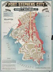
Port Stephens was under consideration as the main seaport for New South Wales,[6] as well as the national capital, and a large city-style subdivision of the peninsula was designed by Walter Burley Griffin, with an architectural plan drawn by his wife Marion, on behalf of the landowner, Henry Halloran, a developer and surveyor.[7] Griffin's plans included two railway stations, a business district, federal and state office sites, a factory district, car parks, wharves, parks and playgrounds.[8] They were approved by Stroud Shire Council on 6 May 1918.[9] Many dirt roads, still visible from the air, date from the original subdivision.[8][5]
Land from the 1918 subdivision is now zoned "non-urban", meaning that construction of buildings is not permitted under any circumstances.[10] Consequently, land sales at North Arm Cove have been the subject of controversy for many years, even being raised as a matter in the NSW Parliament.[10][11] Despite that, many blocks are purchased as an investment and/or for use as weekend retreats. Land is regularly sold and resold as owners become frustrated with being unable to develop their properties.[12][11]
Land use today
Restrictions on land use in the area has meant that only a limited number of residential blocks are available. The local population is concentrated mainly in the village of North Arm Cove, located on the western shore of North Arm cove itself, and on the northern shore of Port Stephens. Many of the small houses that used to be in the area have been demolished and replaced with more expensive homes.
North of the Pacific Highway, land use is mainly rural, and kangaroos, wallabies and koalas are commonly found throughout the area.
References
- Australian Bureau of Statistics (25 October 2007). "North Arm Cove (L) (Urban Centre/Locality)". 2006 Census QuickStats. Retrieved 9 July 2008. Map
- "Suburb Search – Local Council Boundaries – Hunter (HT) – Great Lakes Council". New South Wales Division of Local Government. Archived from the original on 16 January 2013. Retrieved 9 July 2008.
- "North Arm Cove (locality)". Geographical Names Register (GNR) of NSW. Geographical Names Board of New South Wales. Retrieved 9 July 2008.

- "Port Stephens". New South Wales Electoral Commission. Retrieved 23 November 2019.
- "North Arm Cove". Land and Property Management Authority - Spatial Information eXchange. New South Wales Land and Property Information. Retrieved 9 July 2008.
- "North Arm Cove". Landmarks and villages. Port Stephens Council. Retrieved 11 May 2020.
- "Canberra – The Federal Capital Contest". NSW State Archive. Retrieved 8 August 2019.
- "History of Port Stephens". Jimmyweb Pty Ltd. Retrieved 8 August 2019.
- "Plan, showing 10 feet contours, Land Limited's estate, Port Stephens". Trove. National Library of Australia. Retrieved 8 August 2019.
- "Advice on Land at NORTH ARM COVE". Great Lakes Council. 28 August 2007. Archived from the original on 30 August 2007. Retrieved 13 July 2008.;
"Information Regarding 1(A) Rural Land Without Dwelling Entitlements in North Arm Cove, Pindimar, Bundabah, Carrington Localities" (PDF). Great Lakes Council. Retrieved 13 July 2008. - "North Arm Cove Land Sales". Parliament of New South Wales. 27 May 1998. Retrieved 13 July 2008.
- "North Arm Cove, Port Stephens, NSW Real Estate". domain.com.au. Retrieved 13 July 2008.;
"Tea gardens Real Estate (Land at North Arm Cove)". Tea Gardens Real Estate. Retrieved 13 July 2008.
- "Nelson Bay (Nelson Head)". Climate statistics for Australian locations. Bureau of Meteorology. Retrieved 9 July 2008.