North Bethesda, Maryland
North Bethesda is an unincorporated, census-designated place in Montgomery County, Maryland, United States, located just north-west of the U.S. capital of Washington, D.C. Among its 14 neighborhoods, the centrally-located, urbanizing district of White Flint is the commercial and residential hub of North Bethesda. The Pike & Rose development and the Pike District is an initiative of Montgomery County to brand and market this region as "North Bethesda's Urban Core". The WMATA White Flint metro station and Grosvenor-Strathmore metro station serve the region.
North Bethesda, Maryland | |
|---|---|
.jpg.webp) North Bethesda Market East Tower | |
 Location of North Bethesda, Maryland | |
 Boundaries of the North Bethesda CDP, as of 2003 | |
| Coordinates: 39°2′12″N 77°7′13″W | |
| Country | |
| State | |
| County | |
| Area | |
| • Total | 8.9 sq mi (23.0 km2) |
| • Land | 8.8 sq mi (22.9 km2) |
| • Water | 0.0 sq mi (0.0 km2) |
| Elevation | 394 ft (120 m) |
| Population (2013[1]) | |
| • Total | 46,646 |
| • Density | 4,281.5/sq mi (1,653.1/km2) |
| Time zone | UTC−5 (Eastern (EST)) |
| • Summer (DST) | UTC−4 (EDT) |
| ZIP codes | 20814, 20817, 20851, 20852 |
| Area code(s) | 301 |
| FIPS code | 24-56337 |
| GNIS feature ID | 1867297 |
Four of the National Institutes of Health as well other federal agencies, including the Nuclear Regulatory Commission, the Health Resources and Services Administration, and the United States Public Health Service Commissioned Corps, are headquartered in North Bethesda. A number of corporate headquarters are headquartered in North Bethesda, as well as nonprofits such as the American Kidney Fund, the Society of American Foresters and United States Pharmacopeia (USP).
The region is also known for a number of its long-standing institutions, such as the Neo-Georgian Mansion at Strathmore and the Georgetown Preparatory School. The Music Center at Strathmore is also located in North Bethesda.
Geography
As an unincorporated area four miles (6.4 km) northwest of Washington, D.C., North Bethesda's boundaries are not officially defined. North Bethesda is, however, recognized by the United States Census Bureau as a census-designated place for statistical purposes, and by the United States Geological Survey as a populated place located at 39°2′12″N 77°7′13″W (39.036733, −77.120249).[2] North Bethesda borders the city of Rockville to the north, and the unincorporated census-designated places of Bethesda and Potomac to the south and west respectively.
According to the United States Census Bureau, the North Bethesda CDP has a total area of 8.9 square miles (23 km2), all land.
Significant through-roads in North Bethesda include Interstates 270 and 495 and Maryland State Highways 187 (Old Georgetown Road), 355 (Rockville Pike), and 547 (Strathmore Avenue). The Twinbrook, White Flint, and Grosvenor-Strathmore Washington Metro stations all serve the area, as does the Ride On and Metrobus bus systems. A future MARC station is planned as well.[3]
Other landmarks in the area are the Charles E. Smith Jewish Day School, the Kennedy-Shriver Aquatic Center (formerly the Montgomery County Aquatic Center), The Jewish Community Center, the Linden Oak tree, from which the metro was diverted from in an effort to preserve it, and North Bethesda Market, the tallest building in Montgomery County.[4]
Major shopping centers include Pike & Rose (formerly Mid-Pike Plaza), Montrose Crossing, Federal Plaza, and the former White Flint Mall, demolished in 2016, was also a major shopping center.
History
North Bethesda shares a common history with most of its Montgomery County neighbors. Archaeological evidence suggests that Paleo, Archaic, and Woodland Native Americans lived nearby, along the banks of the Potomac River. These peoples traveled along an ancient route known as the Seneca Trail (which is today approximately followed in North Bethesda by Old Georgetown Road). Like many ancient roads, the Seneca Trail followed a ridge line – in this case, the high ground between the Potomac River and Rock Creek. Much later, development would spring up along this route.
The recorded history of the area commences with the colonial era. Settlements formed along Rock Creek and the Seneca Trail in the 17th Century, with recorded land grants in this area known originally as “Dan” and “Leeke Forest.” The far southern edge of the North Bethesda CDP was originally the country estate of the Grosvenor family, whose lineage includes Alexander Graham Bell and a former President of the National Geographic Society. That region continues to bear the family's name, and is the location of the headquarters of the Renewable Natural Resources Foundation. Also in the southern sector of the census designated area, located in the triangle between the two limbs of I-270 and I-495, is a business district that includes several corporate and government agency headquarters.

In the early 19th century, much of the area was part of a 3,700-acre (15 km2) tobacco plantation owned by a slaveowning family with the surname of Riley. One of the Rileys' slaves, Josiah Henson, is thought by historians to be the inspiration for Harriet Beecher Stowe's Uncle Tom's Cabin. In 1806, the Washington Turnpike Company was chartered to improve the old Seneca route, by then known as the Georgetown-Frederick Road. The road was opened in 1828, but had nearly washed away by 1848. The Riley plantation house was located on this road, and the plantation house's kitchen (in which Henson is known to have slept) still stands near the course of this road.
By the late 19th century, the area was privileged with stops along a train route, and by the early 20th century with its own trolley tracks on the line connecting Georgetown and Rockville (along current-day Fleming Avenue). During this time, development bloomed around train and trolley stops, and a number of wealthy families, including those of Captain James Frederick Oyster and Charles I. Corby (who developed methods that revolutionized the baking industry), lived or summered in the area. Nonetheless, the area remained sparsely populated through the 1920s.
The arrival of the automobile eventually transformed the area into a commuter suburb of Washington, D.C. By the 1950s, the area had sprouted a number of developer-conceived neighborhoods with tract houses for the middle-class.
While some traditional neighborhoods remain, other areas have struggled with issues related to suburban sprawl. Like most other suburbs in Montgomery County, the Maryland-National Capital Park and Planning Commission (M-NCPPC) engages in master planning for all development. The White Flint Master Plan is designed to alleviate negative aspects of future high-density development in North Bethesda.[5]
Education
Montgomery County Public Schools serves North Bethesda. Public schools include:[6]
- Garrett Park Elementary School[7]
- Luxmanor Elementary School[8]
- Tilden Middle School[9]
- Walter Johnson High School[10]
- Charles W. Woodward High School (to reopen circa 2025)[11]
Catholic schools (under the Roman Catholic Archdiocese of Washington) include:[6]
- Academy of the Holy Cross[12]
- Holy Cross School - Established in 1961[13]
Other private schools in the CDP include:[6]
- Georgetown Preparatory School[14]
- Charles E. Smith Jewish Day School has two campuses[15]
- Green Acres School (K-8)[16]
- Montrose Christian School formerly operated in North Bethesda CDP.[17]
The Washington Japanese Language School (WJLS, ワシントン日本語学校 Washington Nihongo Gakkō), a supplementary weekend Japanese school, has its school office at Quinn Hall of the Holy Cross Church in North Bethesda, adjacent to Garrett Park.[6][18][19] The WJLS holds its classes in Bethesda.[19][20] The institution, giving supplemental education to Japanese-speaking children in the Washington DC area, was founded in 1958,[21] making it the oldest Japanese government-sponsored supplementary school in the U.S.[22] It previously held classes at Holy Cross Church Elementary and Georgetown Preparatory School in North Bethesda.[23]
The French International School, Lycee Rochambeau, is also located near the region.
Demographics
| Historical population | |||
|---|---|---|---|
| Census | Pop. | %± | |
| 1980 | 22,671 | — | |
| 1990 | 29,656 | 30.8% | |
| 2000 | 38,610 | 30.2% | |
| 2010 | 43,828 | 13.5% | |
| source:[24] | |||
As of the census[25] of 2000, there were 38,610 people, 17,286 households, and 9,662 families residing in the area. The population density was 4,281.5 people per square mile (1,652.7/km2). There were 18,071 housing units at an average density of 2,003.9/sq mi (773.5/km2). The racial makeup of the area was 77.24% White, 4.96% African American, 0.29% Native American, 11.97% Asian, 0.05% Pacific Islander, 2.61% from other races, and 2.88% from two or more races. Hispanic or Latino of any race were 9.53% of the population.
There were 17,286 households, out of which 22.7% had children under the age of 18 living with them, 46.2% were married couples living together, 7.4% had a female householder with no husband present, and 44.1% were non-families. 36.5% of all households were made up of individuals, and 11.6% had someone living alone who was 65 years of age or older. The average household size was 2.17 and the average family size was 2.85.
In the area, the population was spread out, with 17.9% under the age of 18, 6.1% from 18 to 24, 34.0% from 25 to 44, 24.2% from 45 to 64, and 17.8% who were 65 years of age or older. The median age was 40 years. For every 100 females, there were 87.3 males. For every 100 females age 18 and over, there were 83.9 males.
According to survey conducted between 2005 and 2009,[26] the median income for a household in the area was $87,324, and the median income for a family was $113,719. Males had a median income of $79,085 versus $61,793 for females. The per capita income for the area was $51,254. About 2.2% of families and 4.8% of the population were below the poverty line, including 5.1% of those under age 18 and 4.6% of those age 65 or over.
Economy
The corporate headquarters of Lockheed Martin, Coventry Healthcare, Host Hotels & Resorts, Marriott International, and Total Wine & More are in North Bethesda. Four of the National Institutes of Health: the National Institute of Allergy and Infectious Diseases, National Institute on Minority Health and Health Disparities, National Institute of Biomedical Imaging and Bioengineering, and the National Center for Advancing Translational Sciences are also headquartered here. Several units of the United States Public Health Service have headquarters in North Bethesda: the Agency for Healthcare Research and Quality, the Substance Abuse and Mental Health Services Administration, the Indian Health Service, the Health Resources and Services Administration, and the United States Public Health Service Commissioned Corps. Other government agencies based in North Bethesda include the Nuclear Regulatory Commission. Nonprofits based in North Bethesda include the American Kidney Fund, the Society of American Foresters and United States Pharmacopeia (USP). Locally, the Marriott-operated Montgomery County Conference Center, located next to the White Flint metro station, hosts a number of large national conferences every year.
In 2018, the e-commerce giant Amazon named Montgomery County, Maryland as one of its top 20 cities considered in the final running for its second headquarter. White Flint was rumored to be the proposed site if it were to be selected.[27] In late 2018, Amazon announced that the headquarter would be split into two locations in New York and Virginia.
White Flint Mall was for decades a major retail mall here while Pike & Rose nearby is a major new mixed-use development designated by local planning authorities as a dense hub of offices, retail, hotels, residential and entertainment for the area.
Neighborhoods in North Bethesda
Neighborhoods within the North Bethesda CDP include the following:
- Pike & Rose / Pike District
- Luxmanor
- Old Georgetown Estates
- Neilwood
- Wickford
- Tilden Woods
- Windermere
- Arroyo Estates
- Timberlawn
- Old Farm
- Walnut Woods
- Hollyoak
- Weatherburn
- The Crest of Wickford
- The Oaks
- The Cloisters
- White Flint
- Garrett Park Estates
- Halpine (is Rockville)
- Old Georgetown Village
- Randolph Hills
- Wildwood (is Bethesda)
- Chase Crossing
- Grosvenor Park
See also
References
- "FactFinder". U.S. Census Bureau. U.S. Department of Commerce. Archived from the original on February 12, 2020. Retrieved November 17, 2014.
- "US Gazetteer files: 2010, 2000, and 1990". United States Census Bureau. February 12, 2011. Retrieved April 23, 2011.
- White Flint Sector Plan montgomeryplanning.org
- "Montgomery Co. To Open Tallest Tower". www.myFoxDC.com. 2010. Retrieved September 22, 2010.
- "White Flint - North Bethesda Master Plan". Maryland-National Capital Park and Planning Commission. Retrieved May 1, 2012.
- "2010 CENSUS - CENSUS BLOCK MAP: North Bethesda CDP, MD" (Archive). U.S. Census Bureau. Retrieved on April 30, 2014.
- "Home". Garrett Park Elementary School. Retrieved October 24, 2020.
850 Hungerford Drive, Rockville, Maryland 20850
- Compare to the Map of Garrett Park - "Home". Luxmanor Elementary School. Retrieved October 25, 2020.
6201 Tilden Lane Rockville, MD 20852
- Compare address and location to CDP map. - "Home". Tilden Middle School. Retrieved October 24, 2020.
- "Home." Walter Johnson High School. Retrieved on June 19, 2015. "6400 Rock Spring Dr Bethesda, MD 20814"
- "Charles W. Woodward High School Reopening Project". Montgomery County Public Schools. Retrieved October 25, 2020.
11211 Old Georgetown Road Rockville, MD 20852
- Compare address and location to CDP map. - "Home". Academy of the Holy Cross. Retrieved October 24, 2020.
4920 Strathmore Avenue Kensington, MD 20895
- Despite the Kensington address it is in North Bethesda CDP. - "About". Holy Cross School. Retrieved October 24, 2020.
4900 Strathmore Ave., Garrett Park, MD
- Compare to the Map of Garrett Park - "Home". Georgetown Preparatory School. Retrieved October 24, 2020.
10900 Rockville Pike, North Bethesda, MD 20852
- "Home". Charles E. Smith Jewish Day School. Retrieved October 24, 2020.
Lower School 1901 East Jefferson Street Rockville, MD 20852 [...] Upper School 11710 Hunters Lane Rockville, MD 20852
- Home, Green Acres School, retrieved October 24, 2020,
11701 Danville Drive North Bethesda, MD 20852
- "Directions". Montrose Christian School. December 15, 2000. Archived from the original on December 15, 2000. Retrieved October 24, 2020.
5100 Randolph Rockville, MD 20852
- "Map Archived 2014-04-22 at the Wayback Machine" (Archive). Town of Garrett Park. Retrieved on April 30, 2014.
- "Home" (Archive). Washington Japanese Language School. Retrieved on April 16, 2015. "学校事務局 Holy Cross Church, Quinn Hall 2F. 4900 Strathmore Avenue, Garrett Park, MD 20896[...]校舎 ストーンリッジ校 Stone Ridge School of the Sacred Heart 9101 Rockville Pike Bethesda, MD 20814"
- "SRMap2015.pdf." Washington Japanese Language School. Retrieved on April 16, 2015.
- "English Archived 2014-05-02 at the Wayback Machine." Washington Japanese Language School. Retrieved on April 30, 2014. "Washington Japanese Language School c/o Holy Cross Church, Quinn Hall, 4900 Strathmore Avenue, Garrett Park, MD 20896"
- "Andrew M. Saidel Archived 2015-04-15 at WebCite" (Archive). Japan-America Society of Greater Philadelphia (JASGP; フィラデルフィア日米協会とは). Retrieved on April 16, 2015.
- "ワシントン日本語学校概要" (Archive). Washington Japanese Language School. May 6, 2003. Retrieved on April 16, 2015. "学校事務局 Washington Japanese Language School Holy Cross Church, Quinn Hall内. 4900 Strathmore Avenue, Garrett Park, MD 20896" and "ホーリークロス校 Holy Cross Church Elementary School 4900 Strathmore Ave, Garret Park, MD 20896" and "プレプ校 Georgetown Preparatory School 10900 Rockville Pike, North Bethesda, MD 20852" and "セントルーク校 St.Luke Catholic School 7005 Georgetown Pike, McLean, VA 22101"
- "CENSUS OF POPULATION AND HOUSING (1790-2000)". United States Census Bureau. Retrieved July 17, 2010.
- "U.S. Census website". United States Census Bureau. Retrieved January 31, 2008.
- "North Bethesda CDP, Maryland, Selected Economic Characteristics: 2005-2009". United States Census Bureau. Archived from the original on February 10, 2020. Retrieved June 1, 2011.
- "White Flint Mall Lawsuit Put On Hold As Amazon Considers Site For HQ2". Bisnow. April 18, 2018.
Further reading
| Wikimedia Commons has media related to North Bethesda, Maryland. |
- North Bethesda/Garrett Park Master Plan - July 1992
Municipalities and communities of Montgomery County, Maryland, United States | ||
|---|---|---|
| Cities | 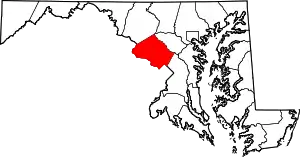 | |
| Towns | ||
| Villages & Special Tax Districts | ||
| CDPs |
| |
| Unincorporated communities | ||
| Footnotes | ‡This populated place also has portions in an adjacent county or counties | |
| ||
| Authority control |
|---|