North Carolina Highway 124
North Carolina Highway 124 (NC 124) is a primary state highway in the U.S. state of North Carolina. It serves to connect the town of Macclesfield and as an alternate to NC 42, entirely in Edgecombe County.
| ||||
|---|---|---|---|---|
 | ||||
| Route information | ||||
| Maintained by NCDOT | ||||
| Length | 9.2 mi[1] (14.8 km) | |||
| Existed | 1933–present | |||
| Major junctions | ||||
| West end | ||||
| ||||
| East end | ||||
| Location | ||||
| Counties | Edgecombe | |||
| Highway system | ||||
| ||||

Route Description
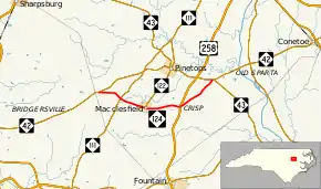
NC 24 is a two-lane rural highway that traverses 9.2 miles (14.8 km) through southern Edgecombe County. Beginning at NC 42, near the Wilson County line, NC 24 goes east 3.6 miles (5.8 km) to Macclesfield intersecting NC 111 at Pitt Crossroads. In Macclesfield, it connects with NC 122, where it goes north to Pinetops. Crossing US 258 at Crisp, NC 124 goes northeasterly 3.1 miles (5.0 km) to NC 42/NC 43, where it ends.[2]
History
NC 124 was established in 1933 as a new primary routing from its current western terminus at NC 42 to US 258 in Crisp.[3] In 1964, NC 124 was extended northeast upgrading an existing secondary road (SR 1004) to its current eastern terminus at NC 42/NC 43.[4]
Junction list
The entire route is in Edgecombe County.
| Location | mi[1] | km | Destinations | Notes | |
|---|---|---|---|---|---|
| | 0.0 | 0.0 | Western terminus | ||
| Pitt Crossroads | 1.7 | 2.7 | |||
| Macclesfield | 3.6 | 5.8 | Southern terminus of NC 122 | ||
| Crisp | 6.1 | 9.8 | |||
| | 9.2 | 14.8 | Eastern terminus | ||
1.000 mi = 1.609 km; 1.000 km = 0.621 mi
| |||||
References
- Google (March 13, 2016). "North Carolina Highway 124" (Map). Google Maps. Google. Retrieved March 13, 2016.
- Edgecombe County, North Carolina (PDF) (Map). North Carolina Department of Transportation. November 2015. Retrieved March 13, 2016.
- North Carolina County Road Survey 1936 (PDF) (Map). Cartography by NCSHC / NCSTC / U.S. Bureau of Public Roads. North Carolina State Tax Commission. 1936. Retrieved March 13, 2016.
- North Carolina County Road Survey 1968 (PDF) (Map). Cartography by NCSHC / U.S. Bureau of Public Roads. North Carolina State Highway Commission. 1968. Retrieved March 13, 2016.
External links
 Media related to North Carolina Highway 124 at Wikimedia Commons
- NCRoads.com: N.C. 124