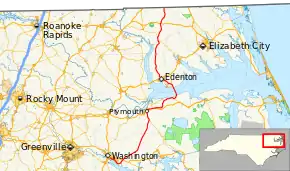
North Carolina Highway 32
North Carolina Highway 32 (NC 32) is a primary state highway in the U.S. state of North Carolina; it goes through several counties and small communities in the northeastern Inner Banks part of the state. It is 103 miles (166 km) in length, and crosses the Albemarle Sound south of Edenton, along with NC 37 and NC 94. The highway continues into Virginia as SR 32.
| ||||
|---|---|---|---|---|
 | ||||
| Route information | ||||
| Maintained by NCDOT | ||||
| Length | 103.4 mi[1] (166.4 km) | |||
| Major junctions | ||||
| South end | ||||
| North end | ||||
| Location | ||||
| Counties | Beaufort, Washington, Chowan, Gates | |||
| Highway system | ||||
| ||||
Route description
- 24.3 Miles in Beaufort County
- 31.7 Miles in Washington County
- 29.5 Miles in Chowan County
- 15.8 Miles in Gates County
- 101.3 Total Miles
Major intersections
| County | Location | mi | km | Destinations | Notes |
|---|---|---|---|---|---|
| Beaufort | Washington | 0.0 | 0.0 | Southern terminus | |
| 8.3 | 13.4 | ||||
| Washington | | 32.0 | 51.5 | South end of NC 45 overlap; Northern terminus of NC 99 | |
| Plymouth | 35.3 | 56.8 | North end of concurrency with NC 45 | ||
| 36.7 | 59.1 | West end of US 64 overlap | |||
| 39.5 | 63.6 | Brief 0.3 mile overlap with NC 45 | |||
| Roper | 40.6 | 65.3 | East end of US 64 ovelap | ||
| Mackeys | 48.2 | 77.6 | Eastern terminus of NC 308 | ||
| | 53.4 | 85.9 | South end of NC 37 and NC 94 overlap | ||
| Albemarle Sound | Albemarle Sound Bridge | ||||
| Chowan | | 60.2 | 96.9 | Northern terminus of NC 94 | |
| St. Johns | 60.9 | 98.0 | North end of NC 37 overlap | ||
| Edenton | 66.1 | 106.4 | South end of Business US 17 overlap | ||
| 66.7 | 107.3 | North end of Business US 17 overlap | |||
| 67.3 | 108.3 | Diamond interchange | |||
| Gliden | 86.2 | 138.7 | South end of NC 37 overlap | ||
| Gates | Mintonsville | 88.3 | 142.1 | North end of NC 37 overlap | |
| Sunbury | 95.2 | 153.2 | |||
| | 103.5 | 166.6 | Northern terminus; Virginia state line | ||
1.000 mi = 1.609 km; 1.000 km = 0.621 mi
| |||||
References
- Google (December 4, 2017). "North Carolina Highway 32" (Map). Google Maps. Google. Retrieved December 4, 2017.
External links
 Media related to North Carolina Highway 32 at Wikimedia Commons
This article is issued from Wikipedia. The text is licensed under Creative Commons - Attribution - Sharealike. Additional terms may apply for the media files.
