North Carolina Highway 94
North Carolina Highway 94 (NC 94) is a primary state highway in the U.S. state of North Carolina. It runs from Hyde County in Swan Quarter to Chowan County near Edenton.
| ||||
|---|---|---|---|---|
 | ||||
| Route information | ||||
| Maintained by NCDOT | ||||
| Length | 73.5 mi[1] (118.3 km) | |||
| Existed | 1930–present | |||
| Tourist routes | ||||
| Major junctions | ||||
| South end | ||||
| North end | ||||
| Location | ||||
| Counties | Hyde, Tyrrell, Washington, Chowan | |||
| Highway system | ||||
| ||||

Route description
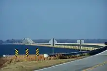
The route spans the Albemarle Sound at the 3.5-mile (5.6 km) Albemarle Sound Bridge, connecting Chowan and Washington Counties. It also crosses Lake Mattamuskeet at the Mattamuskeet National Wildlife Refuge. The highway passes through the following municipalities:
History
NC 94 was established in 1930 as a new primary spur routing from NC 91, in Swindell Fork to Fairfield.[2] In 1931, NC 94 was extended north on new primary routing to NC 90, in Columbia.[3] In 1935, NC 94's southern terminus was rerouted to US 264, in Rose Bay; the reroute was a swap with NC 6.[4] In 1942, NC 94 was rerouted at Fairfield onto new primary routing directly south through Lake Mattamuskeet. The nearly 6-mile (9.7 km) causeway connects directly with US 264 near New Holland; the former alignment that went around the western banks of Lake Mattamuskeet were downgraded to secondary roads (Piney Woods Road (SR 1305) and Turnpike Road (SR 1304)).[5]
In 2000, NC 94 was extended both directions: At Lake Comfort, it goes west on a 7-mile (11 km) concurrency with US 264 to Swan Quarter, where it then splits off onto Main Street and continues till it reaches NC 45, its current southern terminus. At Columbia, NC 94 goes west on a 17-mile (27 km) concurrency with US 64 near Pea Ridge, where it then switches concurrences with NC 32. Traveling north, it crosses over the Albemarle Sound, then separates from NC 32 near St. Johns. On Soundside Road, it connects with Northeastern Regional Airport before reconnecting with NC 32 near Edenton and its current northern terminus.[6] In 2003, US 64 was rerouted onto new primary routing through Washington County and part of Tyrrell County, leaving NC 94 continuing along its former alignment.[7]
Major intersections
| County | Location | mi[1] | km | Destinations | Notes |
|---|---|---|---|---|---|
| Hyde | Swan Quarter | 0.0 | 0.0 | Southern terminus | |
| 1.5 | 2.4 | West end of US 264 overlap | |||
| Lake Comfort | 8.5 | 13.7 | East end of US 264 overlap | ||
| Tyrrell | Columbia | 43.5 | 70.0 | East end of US 64 overlap; Western terminus of US 64 Bus. | |
| | 44.6 | 71.8 | West end of US 64 overlap | ||
| Washington | | 60.5 | 97.4 | South end of NC 32 and NC 37 overlap | |
| Albemarle Sound | 62.6– 66.1 | 100.7– 106.4 | Albemarle Sound Bridge | ||
| Chowan | | 67.4 | 108.5 | North end of NC 32 and NC 37 overlap | |
| | 73.5 | 118.3 | Northern terminus | ||
1.000 mi = 1.609 km; 1.000 km = 0.621 mi
| |||||
References
- Google (May 16, 2015). "North Carolina Highway 94" (Map). Google Maps. Google. Retrieved May 16, 2015.
- State Highway System of North Carolina (PDF) (Map) (September 1930 ed.). Cartography by NCSHC. Raleigh: North Carolina State Highway Commission. 1930. Retrieved July 31, 2016.
- State Highway System of North Carolina (Map). Cartography by NCSHC. Raleigh: North Carolina State Highway Commission. 1931. Retrieved July 31, 2016.
- State Highway System of North Carolina (Map). Cartography by NCSHC. Raleigh: North Carolina State Highway Commission. 1935. Retrieved July 31, 2016.
- North Carolina Primary Highway System (Map). Cartography by NCSHC. Raleigh: North Carolina State Highway Commission. 1942. Retrieved July 31, 2016.
- "Route Change (2000-04-28)" (PDF). North Carolina Department of Transportation. April 28, 2000. Retrieved July 31, 2016.
- "Route Change (2003-09-15)" (PDF). North Carolina Department of Transportation. September 15, 2003. Retrieved July 31, 2016.
External links
 Media related to North Carolina Highway 94 at Wikimedia Commons
- NCRoads.com: N.C. 94