Interstate 95 in North Carolina
Interstate 95 (I-95) is a major Interstate Highway, running along the East Coast of the United States from Florida to Maine. In North Carolina, I-95 runs diagonally across the eastern third of the state, from Rowland at the South Carolina border to Pleasant Hill at the Virginia border. From south to north, the route passes through or near the cities of Lumberton, Fayetteville, Wilson, Rocky Mount and Roanoke Rapids. The route goes through a mostly rural area of the state, avoiding most of the major metro areas of North Carolina. It forms the informal border between the Piedmont and Coastal Plain regions of the state. There are two auxiliary routes for I-95 in the state: I-295, a partially completed bypass of Fayetteville and I-795, a spur route connecting I-95 to the city of Goldsboro.
| ||||
|---|---|---|---|---|
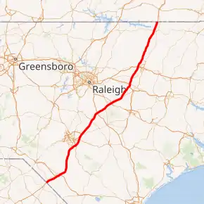
I-95 highlighted in red | ||||
| Route information | ||||
| Maintained by NCDOT | ||||
| Length | 181.71 mi[1][2] (292.43 km) | |||
| Existed | 1958[3]–present | |||
| Major junctions | ||||
| South end | ||||
| North end | ||||
| Location | ||||
| Counties | Robeson, Cumberland, Harnett, Johnston, Wilson, Nash, Halifax, Northampton | |||
| Highway system | ||||
| ||||

Route description
Interstate 95 enters North Carolina at the South Carolina line, just north of the South of the Border attraction and just to the south of the town of Rowland. Traveling mostly northeast from the border, the road enters Lumberton where it interchanges with I-74. Frontage roads through Lumberton have extensive travel services, including restaurants, shops, and hotels. Leaving Lumberton, the route turns due north through a rural area of the state, past the small farming community of St. Pauls. I-95 serves as the eastern bypass of Fayetteville where Interstate 95 Business, an older alignment, connects I-95 to downtown Fayetteville.
I-95 interchanges with I-40 in Benson, North Carolina, U.S. 264 in Wilson, and U.S. 64 in Rocky Mount, three of the main east-west routes in the eastern part of the state. The last city it passes is Roanoke Rapids before leaving the state near the unincorporated community of Pleasant Hill at the Virginia border. For most of the route, I-95 is paralleled closely by U.S. 301.
Services
The North Carolina Department of Transportation (NCDOT) operate and maintain two welcome centers and six rest areas along I-95. Welcome centers, which have a travel information facility on site, are located at mile markers 5 (northbound) and 181 (southbound); rest areas are located at mile markers 47 (north and southbound), 99 (north and southbound) and 142 (north and southbound). Common at all locations are public restrooms, public telephones, vending machines, picnic area and barbecue grills.[4]
The North Carolina Department of Public Safety (NCDPS) operate and maintain four truck inspection/weigh stations along I-95. The Robeson County stations are located on both north and southbound at mile marker 24, each has one fixed scale. The Halifax County stations are located on both north and southbound at mile marker 151, each has two fixed scales.[5]
Dedicated and memorial names
Interstate 95 in North Carolina feature numerous dedicated or memorialized bridges, interchanges and stretches of freeway.
- Blue Star Memorial Highway: Official North Carolina honorary name of Interstate 95 throughout the state (approved on June 13, 1980).[6][7][8]
- Dick Fleming Freeway: Official North Carolina name of Interstate 95 from exit 95, in Smithfield, to exit 97, in Selma, in Johnston County. He is honored as being a visionary businessman, who help spur businesses along the two exits and the establishment of Carolina Pottery Store in 1983, which later grew to become Carolina Premium Outlets (approved January, 2013; dedicated March 22, 2013).[9]
- Hector MacLean Highway: Official North Carolina name of Interstate 95 within Lumberton city limits (approved on October 3, 1997).[6]
History
Established in 1956, as part of the Federal Aid Highway Act of 1956, I-95 was routed along or near existing US 301 throughout the state of North Carolina. By 1961, two stretches of the interstate opened: from mile marker 56, in Fayetteville, to mile marker 107, near Kenly; the other a small bypass near Saint Pauls. In 1964, the Saint Pauls section extended further south into Lumberton; while another small stretch opened from US 158, in Roanoke Rapids, to the Virginia state line. In 1969, I-95 was extended further south from Roanoke Rapids to exit 145, in Rocky Mount (later used for NC 4). In 1973, Interstate 95 was completed from Saint Pauls to the South Carolina state line.
By the mid 1970s, I-95 had two gaps along its route in Fayetteville and Kenly-Gold Rock. In May 1978, two Interstate 95 Business loops were established, both overlapping US 301, to help connect through the gaps and make I-95 appear as one continuous route throughout the state. In November 1978, the first gap to be completed was the Kenly-Gold Rock section.[10] The final section of Interstate 95 was completed in 1980, an easterly bypass of Fayetteville.[11][12]
Tolls
The idea of tolling I-95 started in 2001 as a way to pay for improvements along the route. In 2003, state officials sought permission from the Federal Highway Administration for a plan that would cost $3 billion and put toll booths every thirty miles along the entire route. However, this was quickly killed by Governor Mike Easley, who did not support tolls.[13]
In 2006, when the Virginia General Assembly passed the resolution calling for an interstate compact to build a toll highway, North Carolina was asked to join in on the compact of putting tolls along the entire length of Interstate 95 in both states.[14] Again, this was stopped by Governor Mike Easley, who did not see the benefit in such a compact and reiterated his opposition of tolls along Interstate 95.[12]
In 2010, North Carolina leaders revived talks on tolling Interstate 95, submitting a request to the Federal Highway Administration to toll the entire route. Approval would be considered after an environmental assessment and other conditions. Support has grown in a number of factors including the fact that the interstate is mostly rural and used predominantly by out-of-state drivers.[12]
On January 20, 2012, NCDOT received final approval of the Environmental Assessment for improvements along I-95 in North Carolina. The following recommendations were made:
- Widen I-95 to eight lanes (four lanes in each direction) from exit 31 to exit 81;
- Widen the remaining sections of I-95 to six lanes (three lanes in each direction);
- Make necessary repairs to pavement;
- Raise and rebuild bridges;
- Improve interchanges; and
- Bring I-95 up to current safety standards for interstates.
It is estimated to cost $4.4 billion with recommendation that it should be paid through tolls. Construction would begin in two phases: Phase 1 (exit 31-exit 81) would begin in 2016 with tolls starting after completion; phase 2 would begin in 2019, which covers the remainder of the interstate.[15][16][17] With a possible 2019 start date for the tolls, NCDOT plans to install nine overhead toll collection sensors every twenty miles with additional toll collection sensors at exits before tolls (to reduce drivers from jumping off and on at each toll); main toll stations will charge twenty miles each while exit tolls will charge ten miles each. Gaps along the route, where no toll collectors are located, will allow local traffic to utilize the interstate toll free. Though the toll rates have not been established, a NCDOT report suggest charging 19.2 cents per mile (11.9 ¢/km) for cars in the phase 1 section, with a much lower rate of 6.4 ¢/mi (4.0 ¢/km) on phase 2 sections; which would work out to be $19.20 from border to border (trucks with three axles or more will be charged more). Drivers that do not carry a toll transponder (i.e. North Carolina Quick Pass) will have their license numbers recorded by cameras and will be billed by mail, at a higher toll rate.[18]
As of June 5, 2018 a share of $147 million dollars in federal grant money provided by the Trump administration is currently being used to partially fund current upgrades to I-95. There is no current mention of tolls yet.
Future
NCDOT plans to widen I-95 from four to six lanes between mile markers 14 and 21, in Robeson County. However, it is currently flagged "Scheduled for Reprioritization," with no estimated cost or date established.[19]
An improvement project along I-95 includes widening sections of the interstate in Cumberland and Robeson counties between Exit 22 & Exit 40 and in Harnett & Johnston counties between Exit 71 & Exit 81 to eight lanes. Currently, funding is expected for the Cumberland and Robeson section after 2027 and construction scheduled for the Harnett & Johnston counties section in 2026.[20]
Auxiliary routes
| Interstate | City | Type | Notes | |
|---|---|---|---|---|
| Interstate 95 Business | Fayetteville | Business loop | Expressway and boulevard grades. | |
| Interstate 95 Business | Wilson and Rocky Mount | Business loop | Boulevard grade. Decommissioned. | |
| Interstate 295 | Fayetteville | Bypass | Currently 19.3 miles (31.1kms) in length; to be extended. | |
| Interstate 495 | Raleigh | Connector | Connected between I-440 and I-540. Replaced by I-87. | |
| Interstate 795 | Wilson and Goldsboro | Spur |
Exit list
| County | Location | mi[2] | km | Exit | Destinations | Notes |
|---|---|---|---|---|---|---|
| Robeson | | 0.00 | 0.00 | Continuation into South Carolina | ||
| 0.06 | 0.097 | 1 | Signed as exits 1A (south) and 1B (north) southbound; exits 1 northbound and 1A southbound are in South Carolina | |||
| | 2.32 | 3.73 | 2 | |||
| | 7.16 | 11.52 | 7 | Raynham Road – McDonald, Raynham | ||
| | 10.40 | 16.74 | 10 | South end of US 301 overlap | ||
| Lumberton | 13.01 | 20.94 | 13 | Signed as exits 13A (east) and 13B (west); cloverleaf interchange with collector/distributor lanes | ||
| 13.69 | 22.03 | 14 | Permanently closed in 2007; replaced by exit 13 | |||
| 17.03 | 27.41 | 17 | ||||
| 18.74 | 30.16 | 19 | Carthage Road | |||
| 19.85 | 31.95 | 20 | ||||
| 21.53 | 34.65 | 22 | North end of US 301 overlap | |||
| | 25.04 | 40.30 | 25 | |||
| St. Pauls | 31.39 | 50.52 | 31 | |||
| 33.02 | 53.14 | 33 | ||||
| | Proposed interchange (unfunded)[21] | |||||
| Cumberland | | 40.24 | 64.76 | 40 | Northbound exit, southbound entrance | |
| Hope Mills | 41.28 | 66.43 | 41 | |||
| | 43.81 | 70.51 | 44 | Snow Hill Road – Fayetteville Regional Airport | ||
| | 45.98 | 74.00 | 46 | Signed as exits 46A (south) and 46B (north); cloverleaf interchange with collector/distributor lanes | ||
| Fayetteville | 48.93 | 78.75 | 49 | |||
| Vander | 51.58 | 83.01 | 52 | Signed as exits 52A (east) and 52B (west); cloverleaf interchange with C/D lanes | ||
| Eastover | 54.52 | 87.74 | 55 | Murphy Road | ||
| 54.98 | 88.48 | 56 | Southbound exit, northbound entrance | |||
| 57.86 | 93.12 | 58 | Southern terminus of US 13 | |||
| | 61.17 | 98.44 | 61 | Wade–Steadman Road – Wade | ||
| | 65.22 | 104.96 | 65 | |||
| Harnett | | 69.52 | 111.88 | 70 | Bud Hawkins Road | |
| | 70.74 | 113.84 | 71 | Long Branch Road | ||
| Dunn | 72.38 | 116.48 | 72 | Pope Road | ||
| 72.99 | 117.47 | 73 | ||||
| | 74.87 | 120.49 | 75 | Jonesboro Road | ||
| | 76.84 | 123.66 | 77 | Hodges Chapel Road | ||
| Johnston | Benson | 79.42 | 127.81 | 79 | ||
| 80.95 | 130.28 | 81 | Signed southbound as exits 81A (west) and 81B (east) | |||
| Four Oaks | 87.50 | 140.82 | 87 | Keen Road – Four Oaks | ||
| 89.70 | 144.36 | 90 | Leads to Bentonville Civil War Battleground | |||
| Smithfield | 93.04 | 149.73 | 93 | Brogden Road – Smithfield | ||
| 94.75 | 152.49 | 95 | ||||
| Selma | 96.81 | 155.80 | 97 | Southern terminus of unsigned NC 39 | ||
| 98.00 | 157.72 | 98 | Pine Level–Selma Road – Selma | |||
| Micro | 101.28 | 162.99 | 101 | Pittman Road | ||
| 102.43 | 164.85 | 102 | Main Street – Micro | |||
| Kenly | 104.50 | 168.18 | 105 | Bagley Road | ||
| 105.88 | 170.40 | 106 | Truck Stop Road | |||
| 107.12 | 172.39 | 107 | Leads to Gov. Charles B. Aycock Birthplace | |||
| Wilson | | 116.33 | 187.21 | 116 | ||
| Wilson | 119.27 | 191.95 | 119 | Northern terminus of I-795; signed as exits 119A (I-795 south/US 264 east) and 119B (US 264 west); cloverleaf interchange with collector/distributor roadways | ||
| 121.37 | 195.33 | 121 | ||||
| Nash | | 126.82 | 204.10 | 127 | ||
| | 132.27 | 212.87 | 132 | |||
| Rocky Mount | Sunset Avenue | Proposed interchange (unfunded).[22][23] | ||||
| 138.32 | 222.60 | 138 | Signed as exits 138A (west) 138B (east); cloverleaf interchange with collector/distributor roadways; leads to NC Aquarium and Cape Hatteras National Seashore | |||
| Dortches | 140.69 | 226.42 | 141 | |||
| Rocky Mount | 144.99 | 233.34 | 145 | |||
| | 149.63 | 240.81 | 150 | |||
| Halifax | | 153.54 | 247.10 | 154 | ||
| | 160.37 | 258.09 | 160 | Leads to Medoc Mountain State Park | ||
| | 167.56 | 269.66 | 168 | |||
| Roanoke Rapids | 170.57 | 274.51 | 171 | |||
| 172.81 | 278.11 | 173 | ||||
| Roanoke River | Roanoke River Bridges | |||||
| Northampton | | 175.67 | 282.71 | 176 | ||
| | 179.87 | 289.47 | 180 | |||
| | 181.36 | 291.87 | Continuation into Virginia | |||
1.000 mi = 1.609 km; 1.000 km = 0.621 mi
| ||||||
References
- Federal Highway Administration Route Log and Finder List, Main Routes of the Dwight D. Eisenhower National System Of Interstate and Defense Highways as of October 31, 2002
- Google (February 13, 2012). "Interstate 95 in North Carolina" (Map). Google Maps. Google. Retrieved February 13, 2012.
- "I-95 Fact Sheet" (PDF). North Carolina Department of Transportation. June 21, 2008. Archived from the original on June 21, 2008. Retrieved June 20, 2014.CS1 maint: bot: original URL status unknown (link)
- "NCDOT: North Carolina Rest Areas System". North Carolina Department of Transportation. Retrieved December 29, 2014.
- "NCDPS - Weigh Stations". North Carolina Department of Public Safety. Archived from the original on December 30, 2014. Retrieved December 29, 2014.
- "North Carolina Memorial Highways and other Named Facilities" (PDF). Retrieved October 7, 2012.
- "NCDOT: NC Blue Star Memorial Marker Locations". Archived from the original on May 22, 2011. Retrieved October 7, 2012.
- "The Blue Star Memorial Marker Program Directory" (PDF). Archived from the original (PDF) on October 20, 2012. Retrieved October 10, 2012.
- Staff (March 22, 2013). "NCDOT Names Section of I-95 in Johnston County as Dick Fleming Freeway". Raleigh, NC: North Carolina Department of Transportation. Archived from the original on December 10, 2014. Retrieved March 31, 2013.
- "Opening of I-95 Set For Monday". Spring Hope Enterprise. November 16, 1978. Retrieved February 26, 2015.
- "NCRoads.com: I-95". Retrieved January 21, 2012.
- Siceloff, Bruce (June 13, 2010). "Talk of I-95 tolls revives". The News & Observer. Raleigh, NC. Retrieved January 21, 2012.
- "Interstate-Guide: Interstate 95". Retrieved January 21, 2012.
- "SJ 184 Interstate Route 95". Archived from the original on May 24, 2011. Retrieved January 21, 2012.
- Staff (January 20, 2012). "Environmental Assessment Approved for I-95 Improvements". NCDOT. Archived from the original on December 24, 2012. Retrieved January 21, 2012.
- The Associated Press (January 21, 2012). "NC report recommends tolls on Interstate 95". The News & Observer. Raleigh, NC. Retrieved January 21, 2012.
- Dorsey, Steve (January 21, 2012). "NC DOT considers making I-95 a toll road". Durham, NC: WTVD-TV. Retrieved January 21, 2012.
- Siceloff, Bruce (February 12, 2012). "Plan fights evasion of I-95 toll in North Carolina". The News & Observer. Raleigh, NC. Retrieved February 13, 2012.
- "NCDOT: Project I-3806". Archived from the original on January 9, 2012. Retrieved January 21, 2012.
- webmaster. "NCDOT News Release: Fourteen New Projects for Division 6 in Updated Draft Transportation Plan". apps.ncdot.gov. Archived from the original on 2018-03-16. Retrieved 2018-03-15.
- Staff. "NCDOT Project U-2519". North Carolina Department of Transportation. Archived from the original on February 9, 2012. Retrieved February 14, 2012.
- Staff. "City of Rocky Mount TIP Status Report" (PDF). City of Rocky Mount. Archived from the original (PDF) on 2012-03-24. Retrieved February 14, 2012.
- Staff. "NCDOT Project U-5026". North Carolina Department of Transportation. Archived from the original on February 9, 2012. Retrieved February 14, 2012.
External links
 Media related to Interstate 95 in North Carolina at Wikimedia Commons
- Driving95|I-95 Corridor Planning & Financial Study
- Internatate 95 North Carolina @ SoutheastRoads.com (AARoads)
- Exitlists.com (I-95)
| Previous state: South Carolina |
North Carolina | Next state: Virginia |
| ||