North East, Maryland
North East is a town in Cecil County, Maryland, United States. It is located between Philadelphia and Baltimore. The population was 3,572 at the 2010 census.
North East, Maryland | |
|---|---|
 | |
 Location of North East, Maryland | |
| Coordinates: 39°36′1″N 75°56′32″W | |
| Country | |
| State | |
| County | |
| Settled | 1658 |
| Incorporated | 1850[1] |
| Government | |
| • Mayor | Robert F. McKnight |
| Area | |
| • Total | 2.06 sq mi (5.33 km2) |
| • Land | 2.02 sq mi (5.24 km2) |
| • Water | 0.04 sq mi (0.09 km2) |
| Elevation | 16 ft (5 m) |
| Population | |
| • Total | 3,572 |
| • Estimate (2019)[4] | 3,642 |
| • Density | 1,800.30/sq mi (695.14/km2) |
| Time zone | UTC-5 (Eastern (EST)) |
| • Summer (DST) | UTC-4 (EDT) |
| ZIP code | 21901 |
| Area code(s) | 410 |
| FIPS code | 24-56450 |
| GNIS feature ID | 0586223 |
| Website | http://www.northeastmd.org/ |
The Turkey Point Light Station was listed on the National Register of Historic Places in 2002.[5] The Gilpin's Falls Covered Bridge was listed in 2008.[5]
Geography
North East is located at 39°36′01″N 75°56′32″W.[6]
According to the United States Census Bureau, the town has a total area of 2.11 square miles (5.46 km2), of which 2.06 square miles (5.34 km2) is land and 0.05 square miles (0.13 km2) is water.[7]
Demographics
| Historical population | |||
|---|---|---|---|
| Census | Pop. | %± | |
| 1850 | 338 | — | |
| 1870 | 748 | — | |
| 1880 | 988 | 32.1% | |
| 1890 | 1,249 | 26.4% | |
| 1900 | 969 | −22.4% | |
| 1910 | 974 | 0.5% | |
| 1920 | 1,112 | 14.2% | |
| 1930 | 1,412 | 27.0% | |
| 1940 | 1,328 | −5.9% | |
| 1950 | 1,517 | 14.2% | |
| 1960 | 1,628 | 7.3% | |
| 1970 | 1,818 | 11.7% | |
| 1980 | 1,469 | −19.2% | |
| 1990 | 1,913 | 30.2% | |
| 2000 | 2,733 | 42.9% | |
| 2010 | 3,572 | 30.7% | |
| 2019 (est.) | 3,642 | [4] | 2.0% |
| U.S. Decennial Census[8] | |||
2010 census
As of the census[3] of 2010, there were 3,572 people, 1,433 households, and 901 families living in the town. The population density was 1,734.0 inhabitants per square mile (669.5/km2). There were 1,651 housing units at an average density of 801.5 per square mile (309.5/km2). The racial makeup of the town was 87.2% White, 7.6% African American, 0.4% Native American, 1.5% Asian, 1.0% from other races, and 2.4% from two or more races. Hispanic or Latino of any race were 3.3% of the population.
There were 1,433 households, of which 38.3% had children under the age of 18 living with them, 38.0% were married couples living together, 17.4% had a female householder with no husband present, 7.4% had a male householder with no wife present, and 37.1% were non-families. 29.6% of all households were made up of individuals, and 9.4% had someone living alone who was 65 years of age or older. The average household size was 2.49 and the average family size was 3.03.
The median age in the town was 30.7 years. 26.7% of residents were under the age of 18; 11% were between the ages of 18 and 24; 31.1% were from 25 to 44; 22.1% were from 45 to 64; and 9.2% were 65 years of age or older. The gender makeup of the town was 47.7% male and 52.3% female.
2000 census
As of the census[9] of 2000, there were 2,733 people, 1,081 households, and 701 families living in the town. The population density was 1,730.8 people per square mile (667.9/km2). There were 1,215 housing units at an average density of 769.5 per square mile (296.9/km2). The racial makeup of the town was 93.82% White, 3.18% African American, 0.40% Native American, 0.88% Asian, 0.44% from other races, and 1.28% from two or more races. Hispanic or Latino of any race were 1.54% of the population.
There were 1,081 households, out of which 36.4% had children under the age of 18 living with them, 42.4% were married couples living together, 16.7% had a female householder with no husband present, and 35.1% were non-families. 27.8% of all households were made up of individuals, and 10.5% had someone living alone who was 65 years of age or older. The average household size was 2.52 and the average family size was 3.04.
In the town, the population was spread out, with 29.2% under the age of 18, 10.1% from 18 to 24, 31.7% from 25 to 44, 18.3% from 45 to 64, and 10.7% who were 65 years of age or older. The median age was 31 years. For every 100 females, there were 91.7 males. For every 100 females age 18 and over, there were 87.9 males.
The median income for a household in the town was $39,563, and the median income for a family was $39,417. Males had a median income of $34,545 versus $26,768 for females. The per capita income for the town was $18,287. About 14.9% of families and 15.2% of the population were below the poverty line, including 19.4% of those under age 18 and 14.1% of those age 65 or over.
Education
It is within Cecil County Public Schools.
- North East Elementary
- North East Middle
- North East High
- Cecil School of Technology
Private:
- The Tome School (K-12)
Tertiary:
Transportation

U.S. Route 40 is the main east–west road through North East; it passes through the town on Pulaski Highway and heads east to Elkton and west to Perryville. Maryland Route 7 heads east–west through North East along Philadelphia Road. Maryland Route 272 is the main north–south road through North East; it passes through the center of town along the one-way pair of Mauldin Avenue northbound and Main Street southbound and heads south as Turkey Point Road to Elk Neck State Park and north as North East Road to an interchange with Interstate 95. Interstate 95 heads south toward Baltimore and Washington, D.C. and north toward Wilmington and Philadelphia. The Route 2 Cross-County Connection bus operated by Cecil Transit runs between Elkton, North East, Cecil College, Perryville (town and the Perryville station along MARC's Penn Line) and Perry Point Veteran's Medical Center.
Historic sites
Historic sites in North East include:
- St. Mary Anne's Episcopal Church, built in 1742
- The Turkey Point Light Station
- The Gilpin's Falls Covered Bridge
Notable people
- Harry Anderson, (September 10, 1931 – June 11, 1998), former MLB player
- Theodor "TJ" Beckert (Higher Education Professional), (December 23, 1991- ), NEHS Class of 2011
References
- "North East". Maryland Manual. Retrieved 25 June 2017.
- "2019 U.S. Gazetteer Files". United States Census Bureau. Retrieved July 25, 2020.
- "U.S. Census website". United States Census Bureau. Retrieved 2013-01-25.
- "Population and Housing Unit Estimates". United States Census Bureau. May 24, 2020. Retrieved May 27, 2020.
- "National Register Information System". National Register of Historic Places. National Park Service. April 15, 2008.
- "US Gazetteer files: 2010, 2000, and 1990". United States Census Bureau. 2011-02-12. Retrieved 2011-04-23.
- "US Gazetteer files 2010". United States Census Bureau. Archived from the original on 2011-02-20. Retrieved 2013-01-25.
- "Census of Population and Housing". Census.gov. Retrieved June 4, 2015.
- "U.S. Census website". United States Census Bureau. Retrieved 2008-01-31.
External links
- http://www.northeastmd.org/
- http://www.northeastchamber.org/
- http://www.hmdb.org/marker.asp?marker=1690
- http://www.upperbaymuseum.org
Municipalities and communities of Cecil County, Maryland, United States | ||
|---|---|---|
| Towns | 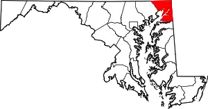 | |
| Unincorporated communities |
| |
| Ghost town | ||
| ||
| Authority control |
|---|