Norwegian County Road 63
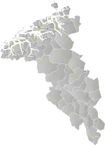
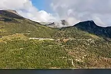
Norwegian County Road 63 (Norwegian: Fylkesvei 63 or Fv63) is a Norwegian county road in Møre og Romsdal county and a very small part in Innlandet county, Norway. It begins at Norwegian National Road 15 along the lake Langvatnet in Skjåk Municipality in Innlandet county and it heads north where it ends at the junction with the European route E136 highway near the town of Åndalsnes in Rauma Municipality, Møre og Romsdal county. The route runs for 103.6 kilometres (64.4 mi) including a single ferry crossing over the Norddalsfjorden. The vast majority of the road is in Møre og Romsdal county, only the southernmost 2.5 kilometres (1.6 mi) lie in the extreme western part of Innlandet county. Both the Langvatnet–Geiranger and Trollstigen sections of the road are closed during winter and spring (usually early November to late May) due to the weather conditions (snow and avalanches).[1] The road passes by a number of notable landmarks, which has led to the earmarking of the route as national tourist route.[2]
| ||||
|---|---|---|---|---|
| Bokmål: Fylkesvei 63 Nynorsk: Fylkesveg 63 | ||||
  | ||||
| Route information | ||||
| Length | 103.6 km (64.4 mi) | |||
| Major junctions | ||||
| South end | ||||
Geiranger village Eidsdal village Sylte village | ||||
| North end | ||||
| Location | ||||
| Counties | Møre og Romsdal, Innlandet | |||
| Major cities | Geiranger, Eidsdal, Sylte | |||
| Highway system | ||||
County Roads in Norway
| ||||
Path (from south to north)
From Langvatnet in the south the road passes the lake of Djupvatnet. From here, the mountain of Dalsnibba can be approached via a minor road. The road descends through a series of hairpin turns northwards towards the village of Geiranger, offering views of the Geirangerfjord in the process. From Geiranger, the road ascends the mountainside through another series of hairpin turns; this section of road is known as the Ørnevegen ("Eagle Road") and reaches a height of 620 metres (2,030 ft) above sea level.[3]
At Eidsdal, a ferry is required in order to cross the Norddalsfjorden.[4] The ferry connects Eidsdal with Linge, from where the road passes through a number of small settlements, including Sylte, before running through the valleys of Valldalen and Meiadalen.
The northernmost section of the road includes the Trollstigen ("The Troll Footpath"), a further series of hairpin turns which descend a particularly steep mountain. From the Trollstigen the road runs in an approximate north-west direction before terminating at the junction with the E136 highway near Åndalsnes.
Diagram
- Skjåk Municipality, Innlandet county
 Fv15 ←Stryn, →Bismo
 Langvatnet — Road closure point in the winter
- Stranda Municipality, Møre og Romsdal county
 Djupvatnet, highest point on the road (1,038 metres or 3,406 feet)
 Geirangervegen (hairpin road)
- Djupvasshytta; road up to Dalsnibba
 Kvandall Bridge
- Opplenskedalen — Road closure point in the winter
- Hole Bridge
- Flå Bridge

 Fv60 Ferry from Geiranger til Hellesylt (May 1 to September 30, 8 trips per day)
- Geiranger village
- Ørnevegen hairpin turns
 Oppskreds Tunnel (600 metres or 2,000 feet)
- Eidsdalselva Bridge
- Eidsdal village
 Fv91 →Norddal
- Ferry from Eidsdal to Linge over the Norddalsfjorden (10 minutes, 3 trips per hour)
 Fv650 ←Sjøholt
- Muri Bridge
 Fv92 →Tafjord
- Sylte village
 Fv95 →Døving
- Uri Bridge
- Hols Bridge
- Fv95 →Døving
- Gudbrandsjuvet Bridge
- Langdalen — Road closure point in the winter

- Stigfossen Bridge
- Trollstigen hairpin turns
- Kverna Bridge
- Hanekamhaug — Road closure point in the winter
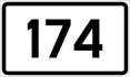 Fv174 ←Veblungsnes
- Sogge Bridge
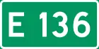 E136 ←Åndalsnes, →Dombås
References
- "Winter road closures in Norway". Retrieved 29 July 2009.
- "Geiranger-Trollstigen page on the National Tourist Routes website". Retrieved 29 January 2016.
- "Eagle Road". Norwegian Tourist Board. Retrieved 29 July 2009.
- "Eidsdal-Linge ferry". Fjord1. Archived from the original on 12 June 2009. Retrieved 29 July 2009.
External links
![]() Road 63 (Norway) travel guide from Wikivoyage
Road 63 (Norway) travel guide from Wikivoyage
|  | |