Novarupta
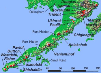
Novarupta (meaning "newly erupted"[2] in Latin) is a volcano that was formed in 1912, located on the Alaska Peninsula in Katmai National Park and Preserve, about 290 miles (470 km) southwest of Anchorage. Formed during the largest volcanic eruption of the 20th century, Novarupta released 30 times the volume of magma of the 1980 eruption of Mount St. Helens.
| Novarupta | |
|---|---|
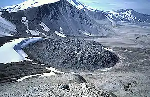 Novarupta's lava dome in July 1987 | |
| Highest point | |
| Elevation | 2,759 ft (841 m) [1] |
| Coordinates | 58°16′0″N 155°9′24″W [1] |
| Geography | |
| Location | Katmai National Park and Preserve, Alaska, U.S. |
| Parent range | Aleutian Range |
| Topo map | USGS Mount Katmai B-4 |
| Geology | |
| Mountain type | Caldera[1] with lava dome |
| Volcanic arc/belt | Aleutian Arc |
| Last eruption | June to October 1912[1] |
Eruption of 1912
| 1912 eruption of Novarupta | |
|---|---|
| Volcano | Novarupta |
| Start date | June 6, 1912 |
| Type | Ultra Plinian |
| Location | Aleutian Range, Alaska 58°16′0″N 155°9′24″W |
| VEI | 6 |
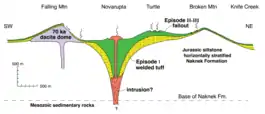
The 1912 eruption that formed Novarupta was the largest to occur during the 20th century. It began on June 6, 1912, and culminated in a series of violent eruptions. Rated a 6 on the Volcanic Explosivity Index,[3] the 60-hour-long eruption expelled 3.1 to 3.6 cubic miles (13 to 15 km3) of ash, thirty times as much as the 1980 eruption of Mount St. Helens.[4][5][6] The erupted magma of rhyolite, dacite, and andesite[7] resulted in more than 4.1 cubic miles (17 km3) of air fall tuff and approximately 2.6 cubic miles (11 km3) of pyroclastic ash-flow tuff.[8] During the 20th century, only the 1991 eruption of Mount Pinatubo in the Philippines and the 1902 eruption of Santa María in Guatemala were of comparable magnitude; Mount Pinatubo ejected 2.6 cubic miles (11 km3) of tephra,[9] and Santa María just slightly less. At least two larger eruptions occurred in the Dutch East Indies (now Indonesia) during the 19th century: the 1815 eruption of Tambora (36 cu mi or 150 km3 of tephra)[10] and the 1883 eruption of Krakatoa (4.8 cu mi or 20 km3 of tephra).[11]
The Novarupta eruption occurred about 6.59 mi (10.61 km) from the peak of Mount Katmai Volcano and 4,000 ft (1,200 m) below the post-eruption Mount Katmai summit. During the eruption a large quantity of magma erupted from beneath the Mount Katmai area, resulting in the formation of a 1.2-mile (2 km) wide, funnel-shaped vent and the collapse of Mount Katmai's summit, creating a 2,000-foot (600 m) deep,[4] 1.9 by 2.5 mi (3 by 4 km) caldera.[12]
The eruption ended with the extrusion of a lava dome of rhyolite[7] that plugged the vent. The 295-foot (90 m) high and 1,180-foot (360 m) wide dome it created forms what is now referred to as Novarupta.[13]
Despite the magnitude of the eruption, no deaths directly resulted.[14]:3[15] Eyewitness accounts from people located downwind in the path of a thick ash cloud described the gradual lowering of visibility to next to nothing.[16] Ash threatened to contaminate drinking water and decimate food resources, but the native Alaskans were aided in their survival by traditional knowledge passed down through generations from previous eruptions. However, the native villages experiencing the heaviest ash falls were abandoned and the inhabitants relocated.[16]
Valley of Ten Thousand Smokes
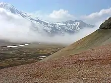
Pyroclastic flows from the eruption formed the Valley of Ten Thousand Smokes, named by botanist Robert F. Griggs, who explored the volcano's aftermath for the National Geographic Society in 1916.[14][17]
The eruption that formed the Valley of Ten Thousand Smokes is one of the few in recorded history to have produced welded tuff, producing numerous fumaroles that persisted for 15 years.[18]
Katmai National Park
Established as a National Park & Preserve in 1980, Katmai is located on the Alaska Peninsula, across from Kodiak Island, with headquarters in nearby King Salmon, about 290 mi (470 km) southwest of Anchorage. The area was originally designated a National Monument in 1918 to protect the area around the 1912 eruption of Novarupta and the 40-square-mile (104 km2), 100-to-700-foot (30 to 210 m) deep, pyroclastic flow of the Valley of Ten Thousand Smokes.[19]
See also
- List of volcanoes in the United States
- Timeline of volcanism on Earth
- Parícutin, a cinder cone volcano in Mexico whose emergence could be fully observed.
References
- "Novarupta". Global Volcanism Program. Smithsonian Institution. Retrieved December 24, 2017.
- "Katmai: Hiking the Valley of Ten Thousand Smokes" (PDF). National Park Service. Retrieved February 17, 2016.
- Simkin, Tom; Lee Siebert (1994). Volcanoes of the World. Tucson, Arizona: Geoscience Press, Inc. p. 117. ISBN 0-945005-12-1.
- Brantley, Steven R. (January 4, 1999). Volcanoes of the United States. Online Version 1.1. United States Geological Survey. p. 30. ISBN 0-16-045054-3. OCLC 156941033. Retrieved September 12, 2008.
- Judy Fierstein; Wes Hildreth; James W. Hendley II; Peter H. Stauffer (1998). "Can Another Great Volcanic Eruption Happen in Alaska? – U.S. Geological Survey Fact Sheet 075-98". Version 1.0. United States Geological Survey. Retrieved September 10, 2008. Cite journal requires
|journal=(help) - Fierstein, Judy; Wes Hildreth (December 11, 2004). "The plinian eruptions of 1912 at Novarupta, Katmai National Park, Alaska". Bulletin of Volcanology. Springer. 54 (8): 646–684. Bibcode:1992BVol...54..646F. doi:10.1007/BF00430778. S2CID 86862398.
- Wood, C.A. and Kienle, J. (editors) (1990) Volcanoes of North America: United States and Canada, Cambridge, Cambridge University Press, ISBN 0-521-36469-8, page 70.
- Judy Fierstein; Wes Hildreth (2001). "Preliminary volcano-hazard assessment for the Katmai volcanic cluster, Alaska: U.S. Geological Survey Open-File Report OF 00–0489" (PDF). United States Geological Survey. Retrieved September 9, 2008. Cite journal requires
|journal=(help) - "Pinatubo: Eruptive History". Global Volcanism Program. Smithsonian Institution. Retrieved January 1, 2009.
- "Tambora". Global Volcanism Program. Smithsonian Institution. Retrieved January 1, 2009.
- "Krakatau: Eruptive History". Global Volcanism Program. Smithsonian Institution. Retrieved January 1, 2009.
- "Katmai". Global Volcanism Program. Smithsonian Institution. Retrieved January 1, 2009.
- Rosi, Mauro; Paolo Papale; Luca Lupi; Marco Stoppato (March 1, 2003). Volcanoes. Firefly Books. p. 219. ISBN 978-1-55297-683-8. OCLC 53901499.
- Griggs, Robert F. (1922). The Valley of Ten Thousand Smokes. Washington, D.C., USA: National Geographic Society. p. 192.
- "Novarupta – Historic eruptions". Alaska Volcano Observatory. November 6, 2012. Retrieved December 19, 2012.
- Schaaf, Jeanne. "Witness: Firsthand Accounts of the Largest Volcanic Eruption in the Twentieth Century". Alaska Park Science. 11 (1).
- Clemens, Janet; Frank Norris (1999). Building in an Ashen Land – Historic Resource Study of Katmai National Park and Preserve. Anchorage, Alaska: National Park Service, Alaska Support Office. Chapter 4.
- Hildreth, Wes (October 1983). "The compositionally zoned eruption of 1912 in the Valley of Ten Thousand smokes, Katmai National Park, Alaska". Journal of Volcanology and Geothermal Research. Elsevier. 18 (1–4): 1–56. Bibcode:1983JVGR...18....1H. doi:10.1016/0377-0273(83)90003-3.
- "Katmai National Park & Preserve". National Park Service. June 29, 2008. Retrieved September 14, 2008.
External links
| Wikimedia Commons has media related to Novarupta. |
- USGS collection of descriptions of Novarupta
- USGS QuickTime video clip on Novarupta (36 seconds/0.8 MB)
- geology.com, Novarupta – topographic maps, annotated satellite images
- Alaska Volcano Observatory: Novarupta
- USGS Photographic Library – novarupta
