Nurstead
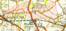
Nurstead (or Nursted) is a locality, ecclesiastical parish and former civil parish situated 3 miles south of Gravesend and ½ a mile north of Meopham, Kent, England.
| Nurstead | |
|---|---|
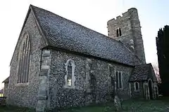 The parish church of Nurstead, St Mildred's | |
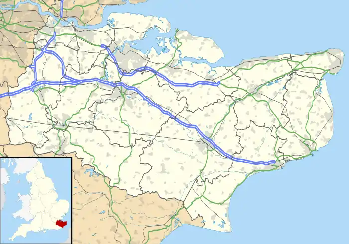 Nurstead Location within Kent | |
| OS grid reference | TQ645655 |
| Civil parish |
|
| District | |
| Shire county | |
| Region | |
| Country | England |
| Sovereign state | United Kingdom |
| Post town | Gravesend |
| Postcode district | DA13 |
| Dialling code | 01474 |
| Police | Kent |
| Fire | Kent |
| Ambulance | South East Coast |
| UK Parliament | |
The parish was in the Hundred of Toltingtrough in the Lathe of Aylesford in the county of Kent. It has an area of 522 acres.[1]
The name of the parish was "Notestede" in the Domesday Book, but by the 18th century although formally spelled "Nutsted" it was at this time commonly called Nursted.[2]
It is at present in the civil parish of Meopham, which is divided into three wards, one of which bears the name "Hook Green and Nurstead".
Nurstead has a small 14th-century church, dedicated to Saint Mildred and this is still the church of the parish, although the benefice is united with Meopham. St Mildred's church is a listed building with walls of oblong flints.[3]
A quarter of a mile north of the church is Nurstead Court, one of the most famous small medieval houses in the country.[4]
The civil parish was abolished in 1935 when it was united with Cobham [5] and in 1963 it was transferred to Meopham.[6] A minor exception was Zimmermans a private bungalow built between 1928 and 1930 on 3/4 acre of land purchased from Nurstead Court Estate. This land was next to the border with Cobham and was not transferred into Meopham in 1963,[7] as indicated in 2000 when a boundary marker was erected on White Post Lane. The Sallows Shaw area south of that road also remained in Cobham.[7]
Nurstead is a small parish, being not quite a mile in extent each way. It lies most of it on high ground, and has a great variety of soils, having in it arable, orchard, and hop ground, and some woodland towards the north boundary of it, next to Northfleet (formerly a parish and then an Urban District; it joins to Meopham southward. In 1797 there were but five houses in it, i.e.. Nurstead Court, Nurstead Hill Farm at the west end of the parish, and Copthall, at the east end, plus two cottages.[8]Nurstead has a thriving village team in the grounds on Nurstead Court.
In the following century and up until the abolition of the civil parish, the population remained low, as follows:[9][10]
| Date | Population |
|---|---|
| 1811 | 29 |
| 1821 | 33 |
| 1831 | 38 |
| 1841 | 36 |
| 1851 | 34 |
| 1881 | 64 |
| 1891 | 56 |
| 1901 | 43 |
| 1911 | 48 |
| 1921 | 50 |
| 1931 | 39 |
Notable people
- James Edmeades (1843–1917), cricketer and British Army officer
Notes
- "British History Online - The core printed primary and secondary sources for the medieval and modern history of the British Isles". www.british-history.ac.uk.
- See The History and Topographical Survey of the County of Kent: Volume 1, author:Edward Hasted, publ. 1797
- You, A Church Near. "Nurstead: St Mildred, Nurstead". A Church Near You. Retrieved 26 January 2016.
- "Meopham Parish Council". www.meopham.org.
- Ministry of Housing Order No. 79448, County of Kent Review Order, dated 1 April 1935
- Meopham Parish Council web site
- Ordnance Survey sheet TQ66NE 6in.to 1 mile, publ. 1966; available from https://maps.nls.uk/ and elsewhere
- See Hasted's survey under the parish of "Nutsted"
- See census tables for this parish in Victoria County History of Kent Vol 3, publ.1932, ed William Page, ISBN 9780712906081.
- "A Vision of Britain through Time - Your national on-line library for local history - Maps, Statistics, Travel Writing and more". www.visionofbritain.org.uk. Retrieved 23 November 2012.
