Nyíradony
Nyíradony is a town in Hajdú-Bihar county, in the Northern Great Plain region of eastern Hungary.
Nyíradony | |
|---|---|
 Flag  Coat of arms | |
 Nyíradony | |
| Coordinates: 47°41′N 21°55′E | |
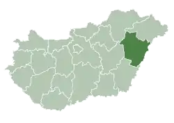
| Country | |
| County | Hajdú-Bihar |
| District | Nyíradony |
| Area | |
| • Total | 96.59 km2 (37.29 sq mi) |
| Population (2001) | |
| • Total | 8,070 |
| • Density | 83.2/km2 (215/sq mi) |
| Time zone | UTC+1 (CET) |
| • Summer (DST) | UTC+2 (CEST) |
| Postal code | 4254 |
| Area code | (+36) 52 |
| Website | www |
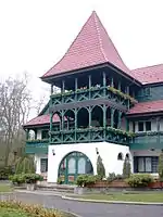
Hunting lodge nearby
Nyíradony
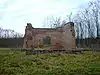
Ruin of little chapel
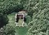
Aerialphotography: Nyíradony - ruins
Geography
It covers an area of 96.59 km2 (37 sq mi) and in 2001, had a population of 8,070.
Places of interest
- New sports hall with indoor pool and sauna
- Greek Catholic church in the city centre with nice wall paintings
- Ruin of a little chapel that was destroyed by the Tatars in the 12th century
Transportation
Accommodation
- In the forest (about 3 kilometers east of Nyíradony) there is a hunting lodge with a guesthouse.
External links
| Wikimedia Commons has media related to Nyíradony. |
- Official website in Hungarian
- Information about Nyíradony on 1hungary.com (English)
| Towns (2) |
| |
|---|---|---|
| Large villages (2) | ||
| Villages (5) | ||
| City with county rights |
|   |
|---|---|---|
| Towns | ||
| Large villages | ||
| Villages |
| |
| Other topics |
| |
This article is issued from Wikipedia. The text is licensed under Creative Commons - Attribution - Sharealike. Additional terms may apply for the media files.