O'Neill Butte
O'Neill Butte is a 6,071-foot (1,850 m)-elevation summit located in the Grand Canyon, in Coconino County of northern Arizona, United States.[3] It is situated 2.5 miles (4.0 km) east-northeast of Grand Canyon Village, one mile (1.6 km) northeast of Mather Point, and one mile immediately northwest of Yaki Point. Cedar Ridge connects O'Neill Butte with Yaki Point on the South Rim. Topographic relief is significant as O'Neill Butte rises 3,600 feet (1,100 m) above the Colorado River in two miles (3.2 km). Access to this prominence is via the South Kaibab Trail which traverses the east slope of the peak. According to the Köppen climate classification system, O'Neill Butte is located in a cold semi-arid climate zone.[4]
| O'Neill Butte | |
|---|---|
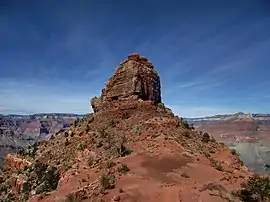 South aspect, from Cedar Ridge | |
| Highest point | |
| Elevation | 6,071 ft (1,850 m) [1] |
| Prominence | 311 ft (95 m) [1] |
| Parent peak | Zoroaster Temple (7,123 ft)[2] |
| Isolation | 4.17 mi (6.71 km) [2] |
| Coordinates | 36°04′14″N 112°05′26″W [3] |
| Geography | |
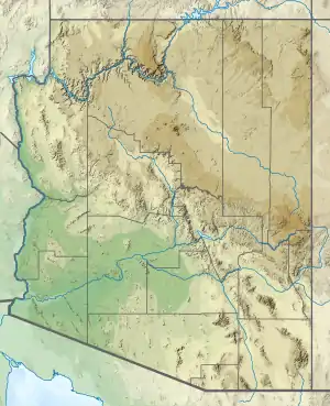 O'Neill Butte Location in Arizona  O'Neill Butte O'Neill Butte (the United States) | |
| Location | Grand Canyon National Park Coconino County, Arizona, US |
| Parent range | Coconino Plateau Colorado Plateau |
| Topo map | USGS Phantom Ranch |
| Geology | |
| Type of rock | limestone, shale, sandstone |
| Climbing | |
| Easiest route | class 5.0 to 5.9 routes |
History
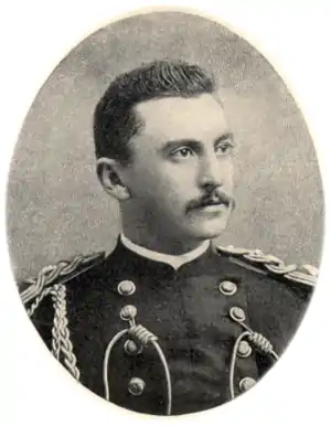
This feature is named for William Owen "Buckey" O'Neill (1860–1898), an Arizona Territory politician, who died as a captain of Theodore Roosevelt's Rough Riders at the Battle of San Juan Hill.[5][6] O'Neill did some prospecting in the Grand Canyon in 1890, and also figured prominently in bringing the railroad to the canyon's South Rim.[7] This feature's name was officially adopted in 1906 by the U.S. Board on Geographic Names.[3]
Geology
The summit block of O'Neill Butte is composed of Permian Esplanade Sandstone, which is the uppermost member of the Pennsylvanian-Permian Supai Group.[8] The rest of the Supai Group overlays Mississippian Redwall Limestone.[9] The cliff-forming Redwall overlays the Cambrian Tonto Group, and below that Paleoproterozoic Vishnu Basement Rocks at river level in Granite Gorge.[10] Precipitation runoff from O'Neill Butte drains north to the Colorado River via Pipe Creek (west aspect) and Cremation Creek (east).
.jpg.webp)
See also
References
- "O'Neill Butte, Arizona". Peakbagger.com. Retrieved 2021-01-17.
- "O'Neill Butte - 6,071' AZ". Lists of John. Retrieved 2021-01-17.
- "O'Neill Butte". Geographic Names Information System. United States Geological Survey. Retrieved 2021-01-17.
- Peel, M. C.; Finlayson, B. L.; McMahon, T. A. (2007). "Updated world map of the Köppen−Geiger climate classification". Hydrol. Earth Syst. Sci. 11. ISSN 1027-5606.
- N.H. Darton, Story of the Grand Canyon of Arizona, 1917, page 80.
- George Wharton James, The Grand Canyon of Arizona How to See It, 1910, Little Brown and Company, pages 11, 62.
- Randy Moore and Kara Felicia Witt, The Grand Canyon: An Encyclopedia of Geography, History, and Culture, 2018, ABC-CLIO Publisher, page 279-280.
- Ron Adkinson, Hiking Grand Canyon National Park, Second Edition, 2006, Globe Pequot Press, ISBN 9780762753673, page 123.
- N.H. Darton, Story of the Grand Canyon of Arizona, 1917, page 12.
- William Kenneth Hamblin, Anatomy of the Grand Canyon: Panoramas of the Canyon's Geology, 2008, Grand Canyon Association Publisher, ISBN 9781934656013.
External links
| Wikimedia Commons has media related to O’Neill Butte. |
- Weather forecast: National Weather Service
- O'Neill Butte rock climbing: Mountainproject.com
- Climbing photos: Themtsarecalling.com