Tonto Group
The Tonto Group is a name for an assemblage of related sedimentary strata, collectively known by geologists as a Group, that comprises the basal sequence Paleozoic strata exposed in the sides of the Grand Canyon. As currently defined, the Tonto groups consists of the Sixtymile Formation, Tapeats Sandstone, Bright Angel Shale (or Formation), Muav Limestone (or Formation), and Frenchman Mountain Dolostone. Historically, it included only the Tapeats Sandstone, Bright Angel Shale, and Muav Limestone.[1][2] Because these units are defined by lithology and three of them interfinger and intergrade laterally, they lack the simple layer cake geology as they are typically portrayed as having and geological mapping of them is complicated.[5][6]
| Tonto Group Stratigraphic range: Cambrian, 508–500 Ma [1] | |
|---|---|
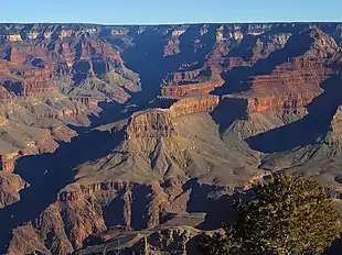 Muav Limestone-(broader-based gray cliff supporting tall-reddish Redwall Limestone cliff) and Bright Angel Shale-(greenish & extensive slope-former), resting on Tapeats Sandstone-(short, dark vertical cliff on gorge rim) and the Tonto Platform, inner canyon, Granite Gorge (the two units are easily seen below the red-stained Redwall Limestone (~550 ft thick)) | |
| Type | Geologic group |
| Unit of | Sauk sequence |
| Sub-units | Frenchman Mountain Dolostone, Muav Limestone, Bright Angel Shale, Tapeats Sandstone, and Sixtymile Formation[1][2] |
| Underlies | Redwall Limestone. (Locally underlies Temple Butte Formation that fills paleovalleys cut into unconformity separating Redwall Limestone from either Frenchman Mountain Dolostone or Muav Limestone. |
| Overlies | Vishnu Basement Rocks and Grand Canyon Supergroup[1][2] |
| Thickness | 1,250 feet (380 m) |
| Lithology | |
| Primary | sandstone, conglomerate, siltstone, shale, limestone, and dolomite |
| Other | calcareous mudstone and glauconitic sandstone |
| Location | |
| Region | |
| Country | |
| Type section | |
| Named for | Tonto Creek or Tonto Basin,[3] |
| Named by | G. K. Gilbert[3] |
| Location | Backtail Canyon[4] |
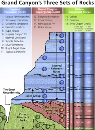
In 1874 and 1875, S. K. Gilbert named the Tonto Group.[7][3] Although it was mentioned that it outcropped in the Tonto Basin and the headwaters of Tonto Creek of south-central Arizona, he did not indicate which of these landforms, for which this group is named. Although the word tonto is silly or foolish in Spanish, this place name for either Tonto Basin or Tonto Creek is derived from the Apache word, Koun’nde. This word means wild, rough people and refers to the indigenous Dilzhe’e Tonto Apache.[8][9] From the area of the Tonto Basin, Gilbert also recognized that similar rocks are exposed near the bottom of the Grand Canyon. From youngest to oldest, Gilbert subdivided the Tonto Group into the Marbled limestone (now subdivided into the Muav Limestone and Frenchman Dolostone); the Tonto shale (now the Bright Angel Shale); the Tonto sandstone (now the Tapeats Sandstone). However, he did not specify a specific type locality.[3] Decades later, R. C. Rose proposed an exposure in Backtail Canyon for a type locality.[4]
In 1914, L F. Noble[10] officially redefined and renamed the formations comprising the Tonto Group. The Tonto Sandstone was renamed the Tapeats Sandstone and the Tonto Shale was renamed the Bright Angel Shale. The Marbled limestone was renamed the Muav Limestone, which by Noble's definition consisted of an upper set of dolomite beds and a lower set of limestone beds.[11]
Later in 1945, E. D. McKee and C. E. Resser[12] subdivided the formations into a number of members in their recognition of the laterally gradation, time transgressive, and interfingering nature of the formations comprising the Tonto Group. In addition, they subdivided the Muav Limestone of Noble into undifferentiated dolomites, overlying an Muav Limestone composed entirely of the lower limestone strata. Furthermore, they removed the undifferentiated dolomites from the Tonto Group.[12] Recently, the undifferentiated dolomites, now known as the Frenchman Mountain Dolostone, have been restore as a formation within the Tonto Group. In addition, along with the Frenchman Mountain Dolostone, the Sixtymile Formation is regarded to be part of the Tonto Group[1][2]
The horizontal Tonto Group units are laid upon the Vishnu Basement Rocks above an angular unconformity as the Vishnu Basement Rocks have a dip of about 15 degrees. This erosion unconformity prior to the deposition of the Tapeats Sandstone upon the tilted Vishnu Basement Rocks is about 1,000 million years (1.0 billion years), and is called the Great Unconformity.
Tonto Platform
The Tonto Platform is a very prominent, wide bench that occurs near the bottom of the eastern Grand Canyon. The gentle slopes of the Tonto Platform were created by rapid backwearing of the Bright Angle Shale. Along its lower edge, the erosion resistant Tapeats Sandstone forms a cliff that marks the outer boundary of the Inner Gorge and the lower boundary of the Outer Canyon. Forming the upper edge of the Tonto Platform are alternating cliffs and steep slopes formed by Cambrian limestones and dolomites. The Tonto Trail is a mostly horizontal trail on the south side of Granite Gorge that lies upon the Tonto Platform.[13][14]
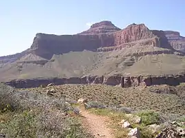 View of Tower of Set peak and sub-unit cliff section from Tonto Trail, Granite Gorge, north of Mohave Point, Grand Canyon Village, South Rim.
The peak is behind and separated from a cliff unit (with small prominence), in front-(photo center, right, Tower of Set (peak) to its left).
Vertical erosion in cliff of Redwall Limestone, upon horizontal Muav Limestone cliff.[15] The Tapeats Sandstone sits in foreground on Granite Gorge, and is seen as thinly-bedded. The slope-former above is the Bright Angel Shale with thin, inter-bedding, as well as one resistant cliff unit. The Redwall Limestone cliff section in Grand Canyon is about 450 feet (137 m) thick.[16].jpeg.webp) close-up and far views of the Tonto Group formations.
close-up and far views of the Tonto Group formations.
Note in far view the cliff-run of the Tapeats Sandstone cliff below the greenish Bright Angel Shale.
See also
| Wikimedia Commons has media related to Tonto Group. |
References
- Karlstrom, K.E., Mohr, M.T., Schmitz, M.D., Sundberg, F.A., Rowland, S.M., Blakey, R., Foster, J.R., Crossey, L.J., Dehler, C.M. and Hagadorn, J.W., 2020. Redefining the Tonto Group of Grand Canyon and recalibrating the Cambrian time scale. Geology, 48(5), pp.425-430.
- Connors, T.B., Tweet, J.S., and Santucci, V.L., 2020. Stratigraphy of Grand Canyon National Park. In: Santucci, V.L., Tweet, J.S., ed., pp. 54–74, Grand Canyon National Park: Centennial Paleontological Resource Inventory (Non-sensitive Version) . Natural Resource Report NPS/GRCA/NRR—2020/2103. National Park Service, Fort Collins, Colorado, 603 pp.
- Gilbert, G.K., 1875. Report upon the geology of portions of Nevada, Utah, California, and Arizona, Chapter 6. In Wheeler, G.M., ed., pp. 17-187, Report on the Geographical and Geological Explorations and Surveys West of the One Hundredth Meridian, vol. 3. U.S. Geological and Geographical Survey, Publication of the Wheeler Survey, Washington, D.C., 681 pp.
- Rose, E.C., 2011. Modification of the nomenclature and a revised depositional model for the Cambrian Tonto Group of the Grand Canyon, Arizona. in Hollingsworth, J.S., Sundberg, F.A., and Foster, J.R., ed., pp. 77–98 and p. 303, Cambrian Stratigraphy and Paleontology of Northern Arizona and Southern Nevada. Museum of Northern Arizona Bulletin 67.
- Beus, S.S. and Billingsley, G.H., 1989. Paleozoic strata of the Grand Canyon, Arizona. in Elston, D.P., Billingsley, G.H., and Young, R.A., ed., pp. 122–127, Geology of Grand Canyon, northern Arizona (with Colorado River guides): Lees Ferry to Pierce Ferry, Arizona. P. M. Hanshaw. Field trips for the 28th International Geological Congress. American Geophysical Union, Washington, D.C.
- Huntoon, P.W., 1989. Cambrian Stratigraphic Nomenclature, Grand Canyon, Arizona‐Mappers Nightmare. in Elston, D.P., Billingsley, G.H., and Young, R.A., ed., pp. 128–130, Geology of Grand Canyon, northern Arizona (with Colorado River guides): Lees Ferry to Pierce Ferry, Arizona. P. M. Hanshaw. Field trips for the 28th International Geological Congress. American Geophysical Union, Washington, D.C.
- Gilbert, G.K., 1874. On the age of the Tonto sandstone (Abst.). Bulletin of the Philosophical Society of Washington, 1, p.109.
- White Mountain Apache Tribe, 1998. Western Apache-English Dictionary: A Community-Generated Bilingual Dictionary. Tempe, Arizona, Arizona State University, Bilingual Review Press, 485 p.
- Atchison, C.L., Parker, W.G., Riggs, N.R., Semken, S., and Whitmeyer, S.J., 2019, Accessibility and inclusion in the field: A field guide for central Arizona and Petrified Forest National Park, in Pearthree, P.A., ed., p. 39–60, Geologic Excursions in Southwestern North America: Geological Society of America Field Guide 55.
- Noble, L.F., 1914. "The Shinumo quadrangle, Grand Canyon district, Arizona." U.S. Geological Survey Bulletin. 549. doi:10.3133/B549. ISSN 0083-1093.
- Noble, L.F., 1922. "A section of the Paleozoic formations of the Grand Canyon at the Bass Trail". "U.S. Geological Survey Bulletin". 131-B, pp. 23-73
- McKee, E.D., and Resser, C.E., 1945, "Cambrian history of ;the Grand Canyon region". "Carnegie Institution of Washington Publication" 563, 168 pp.
- Maxson, J.H., 1946. Relationship of Scenery to Geology in the Grand Canyon. Engineering and Science, 9(3), pp.4-13.
- Dexter, L.R., 2009. Grand Canyon: the puzzle of the Colorado River. in Migoń , P., ed., pp. 49-58, Geomorphological landscapes of the world. Springer, Dordrecht.
- Lucchitta, I. (2001) Hiking Arizona's Geology, Mountaineers's Books, Seattle, Washington. ISBN 0-89886-730-4) pp. 62-68, Kaibab Trail, pp. 66-67, photo and Fig. 10, View to the northwest from the top of the Redwall Limestone along the (S.) Kaibab Trail. The sketch identifies the geologic units visible from here.
- Chronic, H (2001) Roadside Geology of Arizona. The Mountaineers Books, Seattle, Washington. (softcover, ISBN 978-0-87842-147-3) p. 179.
External links
- Mathis, A., and C. Bowman (2007) The Grand Age of Rocks: The Numeric Ages for Rocks Exposed within Grand Canyon, Grand Canyon National Park, Arizona, National Park Service, Grand Canyon National Park, Arizona.
- Rowland, S. (nda) Frenchman Mountain Great Unconformity site. Department of Geoscience, University of Nevada, Las Vegas, Nevada.
- Share, J. (2102a) The Great Unconformity of the Grand Canyon and the Late Proterozoic-Cambrian Time Interval: Part I - Defining It.
- Share, J. (2102a) The Great Unconformity and the Late Proterozoic-Cambrian Time Interval: Part II - The Rifting of Rodinia and the "Snowball Earth" Glaciations That Followed.
- Timmons, M. K. Karlstrom, and C. Dehler (1999) Grand Canyon Supergroup Six Unconformities Make One Great Unconformity A Record of Supercontinent Assembly and Disassembly. Boatman's Quarterly Review. vol. 12, no. 1, pp. 29–32.
- Timmons, S. S. (2003) Learning to Read the Pages of a Book (Grand Canyon Geology Training Manual), National Park Service, Grand Canyon National Park, Arizona.