Oberkrämer
Oberkrämer is a municipality in the Oberhavel district, in Brandenburg, Germany. An experimental farm of wind turbines existed between 1941 and 1945 on the 50 m high Matthias mountain in the area.
Oberkrämer | |
|---|---|
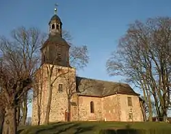 Church in Vehlefanz | |
 Coat of arms | |
Location of Oberkrämer within Oberhavel district 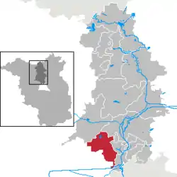 | |
 Oberkrämer  Oberkrämer | |
| Coordinates: 52°42′N 13°06′E | |
| Country | Germany |
| State | Brandenburg |
| District | Oberhavel |
| Subdivisions | 7 districts |
| Government | |
| • Mayor | Peter Leys |
| Area | |
| • Total | 10.754 km2 (4.152 sq mi) |
| Elevation | 54 m (177 ft) |
| Population (2019-12-31)[1] | |
| • Total | 11,727 |
| • Density | 1,100/km2 (2,800/sq mi) |
| Time zone | UTC+01:00 (CET) |
| • Summer (DST) | UTC+02:00 (CEST) |
| Postal codes | 16727 |
| Dialling codes | 03304 |
| Vehicle registration | OHV |
| Website | www.oberkraemer.de |
Sommerswalde
Subdivisions
Oberkrämer consists of formerly separate districts, which as of 31 December 2001 merged with the new municipality of Oberkrämer. Current Population according to Oberkrämer.de:[2]
| Year | Bötzow | Schwante | Vehlefanz | Neu-Vehlefanz | Marwitz | Bärenklau | Eichstädt |
|---|---|---|---|---|---|---|---|
| 2004 | 2.785 | 1.983 | 1.771 | 340 | 1.407 | 1.291 | 942 |
| 2005 | 2.904 | 1.997 | 1.777 | 348 | 1.400 | 1.294 | 939 |
| 2006 | 2.973 | 2.061 | 1.814 | 391 | 1.432 | 1.330 | 926 |
| 2007 | 2.947 | 2.061 | 1.821 | 379 | 1.435 | 1.313 | 929 |
| 2008 | 2.937 | 2.043 | 1.800 | 355 | 1.398 | 1.294 | 876 |
| 2009 | 2.967 | 2.039 | 1.759 | 365 | 1.417 | 1.270 | 848 |
| 2010 | 2.981 | 2.089 | 1.765 | 385 | 1.429 | 1.288 | 850 |
| 2011 | 2.955 | 2.019 | 1.746 | 353 | 1.413 | 1.262 | 843 |
Demography
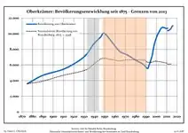 Development of population since 1875 within the current Boundaries (Blue Line: Population; Dotted Line: Comparison to Population development in Brandenburg state; Grey Background: Time of Nazi Germany; Red Background: Time of communist East Germany)
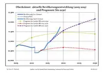 Recent Population Development and Projections (Population Development before Census 2011 (blue line); Recent Population Development according to the Census in Germany in 2011 (blue bordered line); Official projections for 2005-2030 (yellow line); for 2014-2030 (red line); for 2017-2030 (scarlet line)
|
|
|
Photogallery
- Schwante
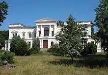
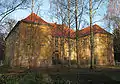 Manor
Manor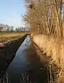 Park
Park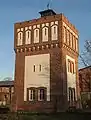 Former water tower
References
- "Bevölkerung im Land Brandenburg nach amtsfreien Gemeinden, Ämtern und Gemeinden 31. Dezember 2019". Amt für Statistik Berlin-Brandenburg (in German). July 2020.
- "http://www.oberkraemer.de → Gemeinde Oberkrämer → Zahlen, Daten, Fakten (in German)". Archived from the original on 2010-03-17. Retrieved 2010-07-29. External link in
|title=(help) - Detailed data sources are to be found in the Wikimedia Commons.Population Projection Brandenburg at Wikimedia Commons
External links
![]() Media related to Oberkrämer at Wikimedia Commons
Media related to Oberkrämer at Wikimedia Commons
Towns and municipalities in Oberhavel | ||
|---|---|---|
Coat of Arms of Oberhavel district | ||
| Authority control |
|---|
This article is issued from Wikipedia. The text is licensed under Creative Commons - Attribution - Sharealike. Additional terms may apply for the media files.
