Zehdenick
Zehdenick is a town in the Oberhavel district, in Brandenburg, Germany. It is situated on the river Havel, 26 kilometres (16 miles) southeast of Fürstenberg/Havel, and 51 kilometres (32 miles) north of Berlin (centre). Since 31 July 2013, the city has the additional appellation "Havelstadt".
Zehdenick | |
|---|---|
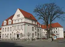
 Town hall | |
 Coat of arms | |
Location of Zehdenick within Oberhavel district 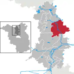 | |
 Zehdenick  Zehdenick | |
| Coordinates: 52°59′N 13°20′E | |
| Country | Germany |
| State | Brandenburg |
| District | Oberhavel |
| Government | |
| • Mayor | Bert Kronenberg (Ind.) |
| Area | |
| • Total | 221.52 km2 (85.53 sq mi) |
| Elevation | 50 m (160 ft) |
| Population (2019-12-31)[1] | |
| • Total | 13,387 |
| • Density | 60/km2 (160/sq mi) |
| Time zone | UTC+01:00 (CET) |
| • Summer (DST) | UTC+02:00 (CEST) |
| Postal codes | 16792 |
| Dialling codes | 03307 |
| Vehicle registration | OHV |
| Website | www.zehdenick.de |
Geography
Zehdenick is located about 60 km north of Berlin on the Havel. It forms the northern starting point of the natural region of the Zehdenick-Spandauer Havelniederung. East extends the Schorfheide-Chorin Biosphere Reserve. The urban area belongs mainly to the historical landscape Uckermark. The subdivisions Marienthal and Ribbeck pertain to the Ruppiner Land, Mildenberg and Zabelsdorf to the Land Löwenberg. Zehdenick has a share in the Naturschutzgebiet Kleine Schorfheide.
Subdivision
The urban area of Zehdenick next to the core city Zehdenick includes 13 villages:
| District | Inhabitants[2] | In the municipality since |
|---|---|---|
| Badingen (with Neuhof and Osterne) | 632 | 26. Oktober 2003 |
| Bergsdorf | 427 | 31. Dezember 2001 |
| Burgwall | 238 | 26. Oktober 2003 |
| Kappe | 136 | 26. Oktober 2003 |
| Klein-Mutz | 438 | 26. Oktober 2003 |
| Krewelin | 281 | 26. Oktober 2003 |
| Kurtschlag | 268 | 26. Oktober 2003 |
| Marienthal | 428 | 26. Oktober 2003 |
| Mildenberg | 707 | 26. Oktober 2003 |
| Ribbeck | 135 | 31. Dezember 2001 |
| Vogelsang | 79 | 31. Dezember 2001 |
| Wesendorf | 249 | 26. Oktober 2003 |
| Zabelsdorf | 242 | 26. Oktober 2003 |
There are exist more living space: Amt Mildenberg, Ausbau (District Ribbeck), Ausbau (Core city Zehdenick), Bergluch, Boddin, Burgwaller Försterei, Deutschboden, Eichholz, Försterei Blockhaus, Großenhof, Hammelstall, Hellberge, Karlshof, Lüthkeshof, Mahnhorst, Mutzer Plan, Neuhof, Osterne, Revierförsterei Wolfsgarten, Rieckesthal, Siedlung II, Wolfsgarten, Ziegelei, Ziegelei Abbau and Ziegelei Ausbau.[3]
Demography
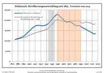 Development of Population since 1875 within the Current Boundaries (Blue Line: Population; Dotted Line: Comparison to Population Development of Brandenburg state; Dotted line: Comparison to population development of Brandenburg state
Grey background: Time of nazi rule—Red background: Time of communist rule)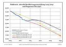 Recent Population Development and Projections (Population Development before Census 2011 (blue line); Recent Population Development according to the Census in Germany in 2011 (blue bordered line); Official projections for 2005-2030 (yellow line); for 2014-2030 (red line); for 2017-2030 (scarlet line)
|
|
|
History
Zehdenick was first mentioned in documentary on 28 December 1216. Zehdenick was at that time a fishing town. Ascanians built a castle here to protect against Pomeranians and Danes.
As a city Zehdenick was 1281 first denoted
Abbey
Zehdenick is the site of the former Cistercian nunnery, Zehdenick Abbey.
Twin cities
Zehdenick is twinned with:
 Castrop-Rauxel, Germany
 Siemiatycze, Poland (since 10 March 2007)
Notable residents
- Paul Georg von Möllendorff (1847–1901), German linguist and diplomat in East Asia
- Marianne Grunthal (1896–1945), teacher, victim of the SS
- Karl Frenzel (1911–1996), SS-Oberscharführer, participant in the Action T4 and section commander in Sobibor extermination camp
- Sebastian Mielitz (born 1989), soccer player
- Sten Nadolny (born 1942), writer
- Günther Morbach (1927–2009), classical bass
- Josefine Preuß (born 1986), actress
Photogallery
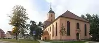 City church
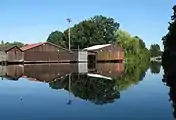 Wentow channel in Marienthal
 Former brickyard in Mildenberg
 River Havel in Mildenberg
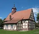
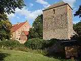 Fortified house and church in Badingen
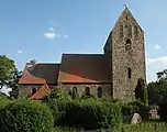 Church in Bergsdorf
 Church in Kappe
 Church in Krewelin
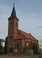 Church in Kurtschlag
 War memorial in Kurtschlag
 Church in Wesendorf
References
- "Bevölkerung im Land Brandenburg nach amtsfreien Gemeinden, Ämtern und Gemeinden 31. Dezember 2019". Amt für Statistik Berlin-Brandenburg (in German). July 2020.
- Website of the city of Zehdenick
- Website: Service portal of the state administration
- Detailed data sources are to be found in the Wikimedia Commons.Population Projection Brandenburg at Wikimedia Commons
External links
![]() Media related to Zehdenick at Wikimedia Commons
Media related to Zehdenick at Wikimedia Commons
Towns and municipalities in Oberhavel | ||
|---|---|---|
Coat of Arms of Oberhavel district | ||
| Authority control |
|---|