Ohingaiti railway station
Ōhingaiti[1] railway station was a station on the North Island Main Trunk in New Zealand.[2][3]
Ōhingaiti railway station | |||||||||||
|---|---|---|---|---|---|---|---|---|---|---|---|
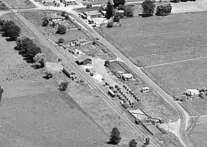 Ōhingaiti railway station in 1957 | |||||||||||
| Location | New Zealand | ||||||||||
| Coordinates | 39.861776°S 175.709629°E | ||||||||||
| Elevation | 279 m (915 ft) | ||||||||||
| Line(s) | North Island Main Trunk | ||||||||||
| Distance | Wellington 222.14 km (138.03 mi) | ||||||||||
| History | |||||||||||
| Opened | 3 November 1902 | ||||||||||
| Closed | Passengers before December 1975 Goods 19 April 1986 | ||||||||||
| Electrified | June 1988 | ||||||||||
| Services | |||||||||||
| |||||||||||
Contracts to build the line north of Ōhingaiti were being let in 1892.[4] The line was in place by 1893,[5] but remained unused for many years,[6] until completion of the Makōhine Viaduct.[7] The station site was cleared of bush in 1894[8] and fenced in 1896. Plans for a station and a ballast pit, 1 mi 21 ch (2.0 km) to the north, were made in 1901, with contracts signed by 18 February 1902.[9]
Makōhine Viaduct was opened on 17 June 1902 and the special train ran on, via Ōhingaiti, to Mangaweka.[7] Dates from 3 July to 30 August 1902 are mentioned for opening goods traffic on the 9 mi 20 ch (14.9 km) line from Mangaonoho to Mangaweka and 30 October for its inspection. New Zealand Railways (NZR) took the line over from the Public Works Department on Monday, 3 November 1902, when the stationmaster was transferred from Ōhingaiti to Mangaweka and Ōhingaiti was officially opened as a flag station, with a platform, privies, urinals, 85 wagon passing loop (extended to 100 wagons in 1973), loading bank, goods shed 41ft x 31ft, sheep and cattle yards. By November 1904 the platform had been asphalted and there was a stationmaster's house. A Post Office operated by Rys Department staff opened on 21 December 1902 and was moved from station on 19 May 1915. A soundproof room was provided for the telephone in 1908 and it was linked to the telephone exchange in 1916.[9]
The village served by the station gradually shrank. In 1893 there were shops, hotels, a school and a sawmill.[10] In 1901 the population was 464.[11] By 1911 it was down to 342[12] and 104 in 1921.[13]
The ballast pit closed in 1940 and the stockyards were removed in 1973. A goods shed, loading bank, passing loop and fertiliser siding remained in 1980, but the station closed to all but wagon loads on 21 July 1980 and to all traffic on Saturday, 19 April 1986.[9]
There is now just a single line through the station site and nearly all traces of the old station have been lost, as State Highway 1 has been straightened across the old goods yard.[14]
References
- "Ōhingaiti". gazetteer.linz.govt.nz. Retrieved 13 January 2021.
- New Zealand Railway and Tramway Atlas (First ed.). Quail Map Co. 1965. pp. 3 & 4.
- Pierre, Bill (1981). North Island Main Trunk. Wellington: A.H&A.W Reed. pp. 289–290. ISBN 0589013165.
- "News Items. COLONIST". paperspast.natlib.govt.nz. 5 May 1892. Retrieved 17 January 2021.
- "THE HON MR SEDDON AT OHINGAITI. NEW ZEALAND MAIL". paperspast.natlib.govt.nz. 24 March 1893. Retrieved 17 January 2021.
- "ALONG THE MAIN TRUNK LINE. MARTON TO OHINGAITI. EVENING POST". paperspast.natlib.govt.nz. 6 July 1900. Retrieved 17 January 2021.
- "OPENING OF THE MAKOHINE VIADUCT. NEW ZEALAND MAIL". paperspast.natlib.govt.nz. 25 June 1902. Retrieved 17 January 2021.
- "OHINGAITI. NEW ZEALAND MAIL". paperspast.natlib.govt.nz. 17 August 1894. Retrieved 17 January 2021.
- "Stations" (PDF). NZR Rolling Stock Lists. Retrieved 10 August 2020.
- "OHINGAITI. ASHBURTON GUARDIAN". paperspast.natlib.govt.nz. 9 January 1893. Retrieved 17 January 2021.
- "Results of the Census of New Zealand, taken for the night of the 31st March, 1901".
- "Report on the results of a census of the Dominion of New Zealand, taken for the night of the 2nd April, 1911" (PDF).
- Results of a Census of the Dominion of New Zealand, Taken for the Night of the 17th April, 1921: Appendices. M.F. Marks. 1921.
- "Basemaps". basemaps.linz.govt.nz. Retrieved 17 January 2021.