Onerahi
Onerahi is a seaside suburb of Whangārei, New Zealand's northernmost city. It is the city's only seaside suburb.[1] It is located 9 km south-east of the centre of Whangārei and is principally a peninsula in the Whangārei Harbour, which empties into the Pacific Ocean.
Onerahi | |
|---|---|
Suburb | |
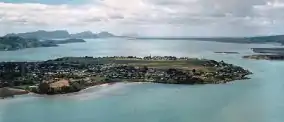 Aerial view of Onerahi, showing Whangarei Airport | |
 Onerahi 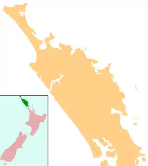 Onerahi | |
| Coordinates: 35°46′S 174°22′E | |
| Country | New Zealand |
| Local authority | Whangarei |
| Population (2018) | |
| • Total | 6,498 |
| Airport(s) | Whangarei Airport |
| Whangārei | ||
|
|
Parua Bay | |
| (Whangārei Harbour) | (Whangārei Harbour) | (Whangārei Harbour) |
The New Zealand Ministry for Culture and Heritage gives a translation of "long beach" for Onerahi.[2]
The suburb's main feature is Whangarei Airport, located on the large flat area at the southern end of the suburb, which was built up using material from the site of a former Maori Pa (fortress) just to the north.
There are two concentric roads around the seaward plateau; the upper one surrounds the airport, and the lower follows the coast.[3] The suburb is connected to Whangarei via the Onerahi Causeway.
Close to the suburb in the harbour is Motu Matakohe or Limestone Island, now being managed to restore its ecosystems.
History

The land for the town was purchased by Henry Walton and William Smellie Graham from Te Tirarau in the mid-1860s. It was then called Kaiwaka Point, but they renamed it Grahamtown. In 1912 it was renamed again to Onerahi (one - which means "beach" and rahi - which can be translated to mean "long and wide") to prevent a conflict with Grahamstown in the Coromandel.[4]
From 1911 to 1933, Onerahi was also served by a branch line railway from the North Auckland Line known as the Onerahi Branch. It was built to provide access to a wharf in Onerahi and when coastal shipping declined severely in the 1930s, the railway was closed. Part of its formation has been retained as a walking track.
Whangarei Airport was established in May 1939 as a RNZAF training base. It was later converted to civilian use with commercial flights commencing in 1947, and has served the Whangarei District since.[5]
Demographics
| Year | Pop. | ±% p.a. |
|---|---|---|
| 2006 | 5,742 | — |
| 2013 | 5,790 | +0.12% |
| 2018 | 6,498 | +2.33% |
| Source: [6] | ||
Onerahi, including Sherwood Rise and Onerahi Park, had a population of 6,498 at the 2018 New Zealand census, an increase of 708 people (12.2%) since the 2013 census, and an increase of 756 people (13.2%) since the 2006 census. There were 2,433 households. There were 3,063 males and 3,438 females, giving a sex ratio of 0.89 males per female. Of the total population, 1,344 people (20.7%) were aged up to 15 years, 1,164 (17.9%) were 15 to 29, 2,631 (40.5%) were 30 to 64, and 1,353 (20.8%) were 65 or older. Figures may not add up to the total due to rounding.
Ethnicities were 76.3% European/Pākehā, 30.1% Māori, 4.2% Pacific peoples, 4.2% Asian, and 2.0% other ethnicities. People may identify with more than one ethnicity.
The percentage of people born overseas was 18.1, compared with 27.1% nationally.
Although some people objected to giving their religion, 50.9% had no religion, 34.9% were Christian, and 7.0% had other religions.
Of those at least 15 years old, 834 (16.2%) people had a bachelor or higher degree, and 1,032 (20.0%) people had no formal qualifications. The employment status of those at least 15 was that 2,253 (43.7%) people were employed full-time, 705 (13.7%) were part-time, and 273 (5.3%) were unemployed.[6]
Education
Onerahi Primary School is a contributing primary (years 1-6) school[7] with a roll of 489 as of March 2020.[8] The school was established in 1893.[9]
Raurimu Avenue School is a full primary (years 1-8) school[10] with a roll of 75 as of March 2020.[8]
Both schools are coeducational.
Sport
The Onerahi Central Cricket Club celebrated their 50th anniversary in 2006, highlighted by a re-run of their first game against Whangarei Boys' High School with best-of selections.[11]
Notes
- "Onerahi Travel Guide". Jasons Travel Media.
- "1000 Māori place names". New Zealand Ministry for Culture and Heritage. 6 August 2019.
- Parkes, W. F. (1992). Guide to Whangarei City and District. p. 22. ISBN 0-473-01639-7.
- Pickmere, Nancy Preece (1986). Whangarei: The Founding Years. pp. 56, 73.
- http://www.whangareiflyingclub.com/history/
- "Statistical area 1 dataset for 2018 Census". Statistics New Zealand. March 2020. Onerahi (108300), Sherwood Rise (108200) and Onerahi Park (108100). 2018 Census place summary: Onerahi 2018 Census place summary: Sherwood Rise 2018 Census place summary: Onerahi Park
- Education Counts: Onerahi Primary School
- "New Zealand Schools Directory". New Zealand Ministry of Education. Retrieved 26 April 2020.
- "Features of Onerahi Primary School". Onerahi Primary School. Archived from the original on 19 April 2004. Retrieved 24 March 2008.
- Education Counts: Raurimu Avenue School
- Eves, Tim (16 October 2006). "Cricket - 'Best Ever' clash for Onerahi 50th - Sport". Northern Advocate. Retrieved 2 February 2014.
External links
- Onerahi School website
- Onerahi Centrals Cricket Club details at ResultsVault
