Orient, Ohio
Orient is a former village in Pickaway County, Ohio, United States. The population was 270 at the 2010 census.
Orient, Ohio | |
|---|---|
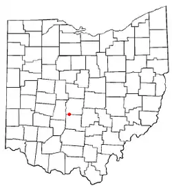 Location of Orient, Ohio | |
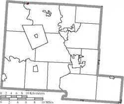 Location of Orient in Pickaway County mayor Jami Hill | |
| Coordinates: 39°48′18″N 83°9′16″W | |
| Country | United States |
| State | Ohio |
| County | Pickaway |
| Township | Scioto |
| Area | |
| • Total | 0.12 sq mi (0.31 km2) |
| • Land | 0.12 sq mi (0.31 km2) |
| • Water | 0 sq mi (0 km2) |
| Elevation | 840 ft (256 m) |
| Population | |
| • Total | 270 |
| • Estimate (2019[4]) | 274 |
| • Density | 2,250.0/sq mi (868.7/km2) |
| Time zone | UTC-5 (Eastern (EST)) |
| • Summer (DST) | UTC-4 (EDT) |
| ZIP code | 43146 |
| Area code(s) | 614 |
| FIPS code | 39-58800[5] |
| GNIS feature ID | 1065214[2] |
Orient is home to the Pickaway Correctional Institution and the Correctional Reception Center.
History
Orient was established as a station on the Baltimore and Ohio Railroad in the northwest corner of Scioto township.
Local residents began seeking dissolution in January 2012.[6] Thirty-three signatures were collected, one more than required by Ohio law to gain ballot access, but the county board of elections rejected the petition when it was found to have more signatures than those certified by the petition circulator.[7] A new petition resulted in a May 2013 vote, in which the village residents supported dissolution by a margin of 38–30.[8]
Geography
Orient is located at 39°48′18″N 83°9′16″W (39.804906, -83.154567).[9]
According to the United States Census Bureau, the village has a total area of 0.12 sqmi (0.31 km2), all land.[1]
Media
Stories about patented inventors, peacock greeters, and connections to national and world history tied to Orient, Ohio are described in the book Amazing Ashville.[10]
Gallery
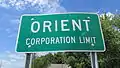 Orient corporation limit sign.
 Water tower in Orient.
Demographics
| Historical population | |||
|---|---|---|---|
| Census | Pop. | %± | |
| 1960 | 310 | — | |
| 1970 | 313 | 1.0% | |
| 1980 | 283 | −9.6% | |
| 1990 | 273 | −3.5% | |
| 2000 | 269 | −1.5% | |
| 2010 | 270 | 0.4% | |
| 2019 (est.) | 274 | [4] | 1.5% |
| US Decennial Census[11] | |||
2010 census
As of the 2010 United States Census,[3] there were 270 people, 96 households, and 67 families in the village. The population density was 2250/sqmi (869/km2). There were 100 housing units at an average density of 833/sqmi (322/km2). The racial makeup of the village was 96.3% White, 0.7% African American, 2.2% Native American, and 0.7% from two or more races. Hispanic or Latino of any race were 0.4% of the population.
There were 96 households, of which 30.2% had children under the age of 18 living with them, 49.0% were married couples living together, 12.5% had a female householder with no husband present, 8.3% had a male householder with no wife present, and 30.2% were non-families. 19.8% of all households were made up of individuals, and 5.2% had someone living alone who was 65 years of age or older. The average household size was 2.81 and the average family size was 3.31.
The median age in the village was 38.5 years. 23.3% of residents were under the age of 18; 8.8% were between the ages of 18 and 24; 27% were from 25 to 44; 29.3% were from 45 to 64; and 11.5% were 65 years of age or older. The gender makeup of the village was 51.5% male and 48.5% female.
2000 census
As of the 2000 United States Census,[5] of 2000, there were 269 people, 95 households, and 72 families residing in the village. The population density was 2,168.3 people per square mile (865.5/km2). There were 102 housing units at an average density of 822.2 per square mile (328.2/km2). The racial makeup of the village was 98.88% White and 1.12% Native American.
There were 95 households, out of which 44.2% had children under the age of 18 living with them, 54.7% were married couples living together, 13.7% had a female householder with no husband present, and 23.2% were non-families. 18.9% of all households were made up of individuals, and 8.4% had someone living alone who was 65 years of age or older. The average household size was 2.83 and the average family size was 3.19.
The village population contained 31.6% under the age of 18, 9.7% from 18 to 24, 30.1% from 25 to 44, 19.7% from 45 to 64, and 8.9% who were 65 years of age or older. The median age was 31 years. For every 100 females, there were 110.2 males. For every 100 females age 18 and over, there were 91.7 males.
The median income for a household in the village was $33,333, and the median income for a family was $38,750. Males had a median income of $31,250 versus $22,344 for females. The per capita income for the village was $15,515. About 14.6% of families and 11.5% of the population were below the poverty line, including 7.9% of those under the age of eighteen and none of those 65 or over.
References
- "US Gazetteer files 2010". US Census Bureau. Archived from the original on January 24, 2012. Retrieved 6 January 2013.
- "US Board on Geographic Names". United States Geological Survey. 25 October 2007. Retrieved 31 January 2008.
- "U.S. Census website". US Census Bureau. Retrieved 6 January 2013.
- "Population and Housing Unit Estimates". Retrieved May 21, 2020.
- "U.S. Census website". US Census Bureau. Retrieved 31 January 2008.
- "Orient Facing Elimination". The Columbus Dispatch. January 15, 2012. Retrieved May 13, 2012.
- "Orient dissolution issue kicked off ballot". The Columbus Dispatch. August 16, 2012. Retrieved August 18, 2012.
- Murphy, Kristi (May 8, 2013). "Voters Dissolve Village In Pickaway County". WOUB. Retrieved June 7, 2013.
- "US Gazetteer files: 2010, 2000, and 1990". US Census Bureau. 12 February 2011. Retrieved 23 April 2011.
- Hines, Bob, 2020. Amazing Ashville--The Most Colorful Community in America. Reedy Press, St. Louis, MO.
- "Census of Population and Housing". Census.gov. Retrieved June 4, 2015.
Municipalities and communities of Pickaway County, Ohio, United States | ||
|---|---|---|
| City | 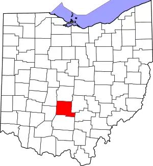 Map of Ohio highlighting Pickaway County | |
| Villages | ||
| Townships | ||
| CDPs | ||
| Unincorporated communities | ||
| Ghost town | ||
| Footnotes | ‡This populated place also has portions in an adjacent county or counties | |
| ||
| Authority control |
|
|---|