Orwell Bridge
The Orwell Bridge is a concrete box girder bridge just south of Ipswich in Suffolk, England. Opened to road traffic in 1982, the bridge carries the A14 road (formerly the A45 road) over the River Orwell.
Orwell Bridge | |
|---|---|
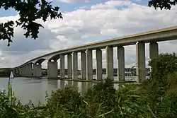 The Orwell Bridge from Orwell Country Park | |
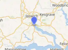
| Coordinates | 52.026909°N 1.16449°E |
| OS grid reference | TM163445 |
| Carries | Motor vehicles (A14 and A12) |
| Crosses | River Orwell (Freston Reach), B1456 |
| Locale | Ipswich (east) and Wherstead (west) |
| Maintained by | Highways England |
| Preceded by | Stoke Bridge |
| Characteristics | |
| Design | Twin box girder bridge |
| Material | Pre-stressed reinforced concrete |
| Total length | 1,000 metres (3,300 ft) |
| Width | 24 metres (79 ft) |
| Height | 43 metres (141 ft) |
| Longest span | 190 metres (620 ft) |
| No. of spans | 18 |
| History | |
| Architect | Frederick Gibberd Partners |
| Engineering design by | Sir William Halcrow & Partners[1] |
| Constructed by | Stevin Construction B.V. |
| Fabrication by | Høsveis & Bofa |
| Construction start | October 1979 |
| Construction end | April 1982 |
| Construction cost | £23.6m |
| Inaugurated | 17 December 1982 |
| Location | |
| |
History
Design
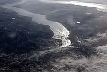
The main span is 190 metres which, at the time of its construction, was the longest pre-stressed concrete span in use in the UK. The two spans adjacent to the main span are 106m, known as anchor spans. Most of the other spans are 59m. The total length is 1,287 metres from Wherstead to the site of the former Ipswich Airport. The width is 24 metres with an air draft of 43 metres; the bridge had to be at least 41 metres high. The approach roads were designed by CH Dobbie & Partners of Cardiff,[2] later bought by Babtie, Shaw and Morton then Jacobs in 2004.
The bridge is constructed of a pair of continuous concrete box girders with expansion joints that allow for expansion and contraction. The girders are hollow, allowing for easier inspection, as well as providing access for services, including telecom, power, and a 711mm water main from the nearby Alton Water reservoir. The necessary inspections still cause major disruption to traffic every six years; during the inspection in the summer of 2005, the delays caused by lane closures and speed restrictions added between 30 and 60 minutes to journey times during the peak commuting periods.
The bridge design took into consideration the impact on the Orwell Estuary, as well as the needs of the port of Ipswich. The location close to the southern edge of Ipswich was deemed convenient for the industrial areas of the West Bank Terminal and Ransomes Industrial Estate on the eastern end. The bridge was set at an angle to the river to get the best relationship to the surrounding terrain.
The air draft of the central span was chosen to be as low as possible without adversely affecting port operations. Although some have said that the resulting hump affects visibility and road safety, there have not been enough incidents causing injury for the Highways Agency to identify it for greater detailed investigation and possible amendments.[4] The consulting engineers were Sir William Halcrow and Partners. Frederick Gibberd Partners worked on the project to ensure the bridge was as sympathetic as possible to its surroundings, with the final design winning the approval of the Royal Fine Art Commission.
The Department for Transport funded the project and, partly because of the bridge, paid for radars and cameras to be installed at the port's Orwell Navigation Service to monitor the river and the bridge.
Construction
Pilings were sunk 40 metres into the river bottom; Pigott Foundations of Ormskirk drilled 1142 piles; the main contractor of the substructure was Stevin Construction B.V., a Dutch company. The main span was constructed using a balanced cantilever technique, casting sections on alternating sides of the pier in a weekly cycle. Høsveis & Bofa of Hønefoss in Norway helped form the box girder (steelwork). The roller bearings were from Maurer AG of Germany. Mageba UK (Swiss) of Bicester supplied the bridge bearings and expansion joints. The pre-stressed concrete box girder sections had VSL tendons and GKN super-strand wire rope. The construction gantries were fabricated by Fairfield Mabey.

It was part of the first part of the Ipswich Bypass; the contract for both approach roads was given to Costain (£10.7m, eastern) and Cementation (£9.3m, western). For this section of the bypass, Robert McGregor & Sons, subcontracting to Cementation laid 6,900m of concrete in 48 days with a slipform paver; Costain laid 10,400m of concrete in 31 days with a concrete train.
Construction of the bridge commenced in October 1979 and was completed 1 April 1982. It was opened on 17 December 1982 by David Howell, Baron Howell of Guildford, then the Secretary of State for Transport.
Maintenance
Bridge bearing replacement works were carried out by Jackson Civil Engineering Ltd during a 52-hour closure of the north deck, carrying the eastbound A14, over the weekend of 11–14 February 2011. The new bridge bearings were designed and manufactured by the engineering company, Freyssinet Ltd.[5]
In February 2014 a meeting of various agencies was held to review to review diversions when A14 and Orwell Bridge are forced to close.[6]
Speed limit
A permanent reduced speed limit of 60 mph was introduced in November 2015 for safety reasons.[7]
Structure
The Stour and Orwell Walk passes over the bridge.
Incidents
Total closures
When the bridge is closed in both directions for more than a short period of time, normally as a safety precaution due to high winds, most of Ipswich's roads are brought to a near-standstill by diverted traffic.[10][11]
| Date | Duration (hours) | Reason | Note |
|---|---|---|---|
| 30 April 2019[12] | 1.5 hours | Police Incident | |
| 16 March 2019[13] | 4 hours | High winds | |
| 13 March 2019[14] | 8 hours | High winds | Storm Gareth |
| 29 November 2018[15] | 4 hours | High winds | |
| 24 January 2018[16] | 5+ hours | High winds | Storm Georgina |
| 18 January 2018[17] | 3 hours | High winds | Storm Fionn |
| 3 January 2018[18] | 17 hours | High winds | Storm Eleanor |
| 20 October 2017[19] | 8 hours | Traffic collision | Fatal crash (6:45am to 2:50pm) |
| 23 February 2017[10] | 5+ hours | High winds | Storm Doris |
| 22 November 2016[11][20] | 5+ hours | High winds | Storm Angus |
| 28 March 2016[21] | 5+ hours | High Winds | Storm Katie |
| 1 July 2015[22] | 0-1 hours | Suicide / Attempted Suicide | |
| 15 April 2015[22] | 1-1.5 hours | Road Traffic Collision | |
| 16 December 2014[22] | 1-1.5 hours | Pedestrian | |
| 29 October 2014[22] | 0-1 hours | Suicide / Attempted Suicide | |
| 21 July 2014[22] | 0-1 hours | Suicide / Attempted Suicide | |
| 13 June 2014[22] | 0-1 hours | Pedestrian | |
| 14 February 2014[23] | 5+ hours | High winds | 2013–14 United Kingdom winter floods |
| 28 October 2013[24] | 5+ hours | High winds | St. Jude storm |
| 4 March 2012[22][25] | 5+ hours | Road Traffic collision | Bridge closed from 8pm on 4th to 3am on 5th. |
Popular culture
The bridge appears in the 1987 Cold War drama The Fourth Protocol, in which two RAF helicopters are shown flying under it, and at the end of the 2013 film The Numbers Station.
References
- IABSE
- IHT The Highway Engineer January 1983
- Shell Orwell
- Chenery, Roger (4 February 2005). "Road safety on the A14 around Ipswich". Highways Agency.
- "Freyssinet Bearing Replacement on A14 Orwell Bridge" (PDF). Archived from the original (PDF) on 16 August 2011. Retrieved 5 May 2011.
- "Ipswich/Suffolk: Summit to look at diversions when A14 and Orwell Bridge are forced to close".
- "Safety improvement work begins on Orwell Bridge".
- "Newmarket to Felixstowe Corridor Study (Section 4.16)" (PDF). East of England Regional Assembly. Archived from the original (PDF) on 28 September 2007. Retrieved 19 June 2006.
- "Port of Felixstowe South Reconfiguration Evidence (Section 7.4)" (PDF). Planning Inspectorate. Retrieved 19 June 2006.
- "A14 Orwell Bridge to stay open today as region deals with aftermath of Storm Doris".
- "Orwell Bridge fully reopens after high winds closed A14 over the river and caused traffic disruption for thousands around Ipswich".
- "Highways England on Twitter". Twitter. Retrieved 30 April 2019.
- "Highways England on Twitter". Twitter. Retrieved 20 March 2019.
- "Highways England on Twitter". Twitter. Retrieved 13 March 2019.
- "Highways England on Twitter". Twitter. Retrieved 29 November 2018.
- "Orwell Bridge CLOSED due to high winds". Ipswich Star. Retrieved 24 January 2018.
- Hirst, Andrew. "Will the A14, Orwell Bridge, close in Suffolk due to high winds? Suffolk police reopen the bridge". Ipswich Star. Retrieved 18 January 2018.
- Howlett, Adam. "A14 Orwell Bridge reopens before evening rush hour". Ipswich Star. Retrieved 5 January 2018.
- "A14 Orwell Bridge opens after being closed for 8 hours after fatal traffic collision".
- "Orwell Bridge in Suffolk re-opens".
- "Storm Katie wreaks havoc across the East".
- "Orwell Bridge Closures".
- "Suffolk/Essex: Orwell Bridge due to re-open this morning following strong overnight winds".
- "Big storm: Orwell Bridge reopened in both directions as St Jude's storm begins to subside".
- No further details of this incident available from local news outlets such as East Anglian Daily Times
External links
| Wikimedia Commons has media related to Orwell Bridge. |
- IHT
- Official website
- Orwell Bridge High Wind Protocol - Briefing paper
- Ipswich, the A14 and the Orwell Bridge 26 January 2017 Highways Agency
- A14 Orwell Bridge Study - Technical note March 2013
