Osage City, Kansas
Osage City is a city in Osage County, Kansas, United States. As of the 2010 census, the city population was 2,943.[8]
Osage City, Kansas | |
|---|---|
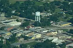 Aerial view of Osage City (2013) | |
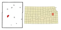 Location within Osage County and Kansas | |
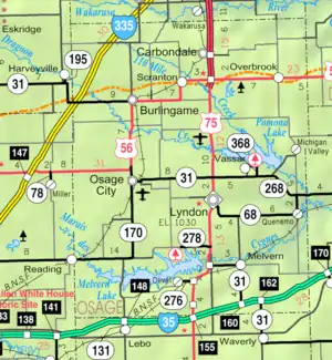 KDOT map of Osage County (legend) | |
| Coordinates: 38°38′3″N 95°49′36″W | |
| Country | United States |
| State | Kansas |
| County | Osage |
| Founded | 1860s |
| Platted | 1869 |
| Incorporated | 1872 |
| Named for | Osage Nation |
| Government | |
| • Type | Mayor–Council |
| • Mayor | Quintin Robert[1][2] |
| Area | |
| • Total | 3.23 sq mi (8.36 km2) |
| • Land | 3.15 sq mi (8.15 km2) |
| • Water | 0.08 sq mi (0.20 km2) |
| Elevation | 1,086 ft (331 m) |
| Population | |
| • Total | 2,943 |
| • Estimate (2019)[5] | 2,809 |
| • Density | 892.03/sq mi (344.45/km2) |
| Time zone | UTC-6 (CST) |
| • Summer (DST) | UTC-5 (CDT) |
| ZIP code | 66523 |
| Area code | 785 |
| FIPS code | 20-53200 [6] |
| GNIS ID | 0479288 [7] |
| Website | osagecity.com |
History
Osage City was surveyed and platted in late 1869, after the route of the Atchison, Topeka and Santa Fe Railway had been fixed, but before it had been built to the city. Osage City was incorporated as a city in April 1872.[9] Like Osage County, the city was named for the Osage Nation.[10]
Osage City was a very busy coal mining town in the 19th century. In the summer of 1870, the first coal mines were opened by the Osage Carbon, Coal & Mining Company. At one time, there were twenty-eight mine shafts and 1,200 men employed.[9]
Geography
Osage City is located at 38°38′3″N 95°49′36″W (38.634069, -95.826759).[11] According to the United States Census Bureau, the city has a total area of 3.29 square miles (8.52 km2), of which, 3.21 square miles (8.31 km2) is land and 0.08 square miles (0.21 km2) is water.[12]
Climate
The climate in this area is characterized by hot, humid summers and generally mild to cool winters. According to the Köppen Climate Classification system, Osage City has a humid subtropical climate, abbreviated "Cfa" on climate maps.[13]
Demographics
| Historical population | |||
|---|---|---|---|
| Census | Pop. | %± | |
| 1880 | 2,098 | — | |
| 1890 | 3,469 | 65.3% | |
| 1900 | 2,792 | −19.5% | |
| 1910 | 2,432 | −12.9% | |
| 1920 | 2,376 | −2.3% | |
| 1930 | 2,402 | 1.1% | |
| 1940 | 2,079 | −13.4% | |
| 1950 | 1,919 | −7.7% | |
| 1960 | 2,213 | 15.3% | |
| 1970 | 2,600 | 17.5% | |
| 1980 | 2,667 | 2.6% | |
| 1990 | 2,689 | 0.8% | |
| 2000 | 3,034 | 12.8% | |
| 2010 | 2,943 | −3.0% | |
| 2019 (est.) | 2,809 | [5] | −4.6% |
| U.S. Decennial Census | |||
Osage City is part of the Topeka, Kansas Metropolitan Statistical Area.
2010 census
As of the 2010 United States census,[4] there were 2,943 people in 1,213 households, including 757 families, in the city. The population density was 916.8 inhabitants per square mile (354.0/km2). There were 1,359 housing units at an average density of 423.4 per square mile (163.5/km2). The racial makeup of the city was 97% White, 0.2% African American, 0.3% Native American, 0.3% Asian, 0.2% from other races, and 2.0% from two or more races. Hispanic or Latino of any race were 3.9% of the population.
Of the 1,213 households 30.2% had children under the age of 18 living with them, 44.8% were married couples living together, 12.8% had a female householder with no husband present, 4.8% had a male householder with no wife present, and 37.6% were non-families. 33.2% of households were one person and 17.4% were one person aged 65 or older. The average household size was 2.34 and the average family size was 2.95.
The median age was 40.8 years. 25.5% of residents were under the age of 18; 6.9% were between the ages of 18 and 24; 21.9% were from 25 to 44; 25.6% were from 45 to 64; and 20.1% were 65 or older. The gender makeup of the city was 47.8% male and 52.2% female.
2000 census
At the 2000 census there were 3,034 people in 1,232 households, including 815 families, in the city. The population density was 888.7 people per square mile (343.5/km2). There were 1,303 housing units at an average density of 381.7 per square mile (147.5/km2). The racial makeup of the city was 96.31% White, 0.36% African American, 1.05% Native American, 0.07% Asian, 0.40% Pacific Islander, 0.53% from other races, and 1.29% from two or more races. Hispanic or Latino of any race were 2.34%.[6]
Of the 1,232 households 33.5% had children under the age of 18 living with them, 52.6% were married couples living together, 9.5% had a female householder with no husband present, and 33.8% were non-families. 30.8% of households were one person and 16.2% were one person aged 65 or older. The average household size was 2.38 and the average family size was 2.95.
The age distribution was 27.1% under the age of 18, 6.4% from 18 to 24, 26.0% from 25 to 44, 19.6% from 45 to 64, and 20.9% 65 or older. The median age was 39 years. For every 100 females, there were 91.5 males. For every 100 females age 18 and over, there were 87.2 males.
The median household income was $31,979, and the median family income was $39,362. Males had a median income of $27,353 versus $21,514 for females. The per capita income for the city was $17,227. About 6.8% of families and 8.8% of the population were below the poverty line, including 5.5% of those under age 18 and 12.9% of those age 65 or over.
Economy
Norseman Plastics is located in Osage City. In 2008, Orbis acquired the company, and changed its name.[14]
Government
The Osage City government consists of a city manager, mayor and eight council members. The council meets the 2nd and 4th Tuesday of each month at 7 pm. The Mayor is elected on two year terms and council members on four year terms.[1][2]
Education
The community is served by Osage City USD 420 public school district.[15]
Transportation
Osage City was located on the National Old Trails Road, also known as the Ocean-to-Ocean Highway, that was established in 1912.
Notable people
- C. D. Batchelor, political editorial cartoonist
- Michael P. Ryan, Marine Major general
- Blake Treinen, baseball player[16]
See also
References
- Osage City - Directory of Public Officials
- Osage City - City Council
- "2019 U.S. Gazetteer Files". United States Census Bureau. Retrieved July 24, 2020.
- "U.S. Census website". United States Census Bureau. Retrieved 2012-07-06.
- "Population and Housing Unit Estimates". United States Census Bureau. May 24, 2020. Retrieved May 27, 2020.
- "U.S. Census website". United States Census Bureau. Retrieved 2008-01-31.
- "US Board on Geographic Names". United States Geological Survey. 2007-10-25. Retrieved 2008-01-31.
- "2010 City Population and Housing Occupancy Status". U.S. Census Bureau. Retrieved February 11, 2012.
- Early history of Osage City
- "Profile for Osage City, Kansas". ePodunk. Retrieved 22 June 2014.
- "US Gazetteer files: 2010, 2000, and 1990". United States Census Bureau. 2011-02-12. Retrieved 2011-04-23.
- "US Gazetteer files 2010". United States Census Bureau. Archived from the original on 2011-02-20. Retrieved 2012-07-06.
- Climate Summary for Osage City, Kansas
- Orbis Corporation acquires Norseman Plastics; October 27, 2008.
- USD 420 school district
- http://cjonline.com/sports/2011-06-07/draft-osage-city-product-treinen
Further reading
External links
| Wikimedia Commons has media related to Osage City, Kansas. |
- City
- Newspaper
- Osage City Herald, local newspaper
- Historical
- Osage City Area Historical Preservation Society
- Historic Images of Osage City, Special Photo Collections at Wichita State University Library
- Maps
- Osage City Map, KDOT
Municipalities and communities of Osage County, Kansas, United States | ||
|---|---|---|
| Cities |  Map of Kansas highlighting Osage County | |
| Unincorporated communities | ||
| Townships |
| |
| Footnotes | †This populated place is designated a Census-Designated Place (CDP) by the United States Census Bureau | |
| ||