National Register of Historic Places listings in Osage County, Kansas
This is a list of the National Register of Historic Places listings in Osage County, Kansas.
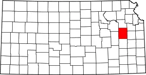
Location of Osage County in Kansas
This is intended to be a complete list of the properties and districts on the National Register of Historic Places in Osage County, Kansas, United States. The locations of National Register properties and districts for which the latitude and longitude coordinates are included below, may be seen in a map.[1]
There are 14 properties and districts listed on the National Register in the county.
- This National Park Service list is complete through NPS recent listings posted February 5, 2021.[2]
Current listings
| [3] | Name on the Register[4] | Image | Date listed[5] | Location | City or town | Description |
|---|---|---|---|---|---|---|
| 1 | Arvonia School | 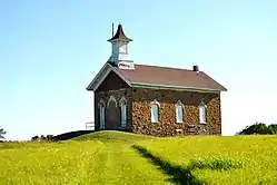 Arvonia School |
July 3, 2012 (#12000387) |
S. Arvonia Rd. 38°28′42″N 95°52′15″W |
Lebo | One of Kansas' earliest architect-designed schools, built in 1872. |
| 2 | Arvonia Township Hall | January 11, 2017 (#100000516) |
S. Arvonia Rd. 38°28′49″N 95°52′10″W |
Lebo | ||
| 3 | Atchison, Topeka, and Santa Fe Pratt Truss Bridge | May 9, 2003 (#03000364) |
SE Pine St., 0.1 miles (0.16 km) south of intersection with E. Emporia St. 38°30′19″N 95°38′07″W |
Melvern | ||
| 4 | Banner Hereford Farm | June 12, 1998 (#98000659) |
19355 S. Berryton Rd. 38°42′56″N 95°38′31″W |
Scranton | ||
| 5 | Calvinistic Methodist Church | July 3, 2012 (#12000388) |
8090 W. 9th St. 38°28′45″N 95°52′12″W |
Lebo | ||
| 6 | Cow-Killer Archeological Site | June 24, 1975 (#75000719) |
Address restricted |
Melvern | ||
| 7 | Samuel Hunt Grave | May 11, 1995 (#95000586) |
K-31, east of crossing of Interstate 335 (the Kansas Turnpike) 38°45′15″N 95°55′32″W |
Burlingame Township | ||
| 8 | Karnes Stone Barn | January 21, 2004 (#03001468) |
4204 E. 129th St. 38°50′02″N 95°35′30″W |
Carbondale | ||
| 9 | Lyndon Carnegie Library | 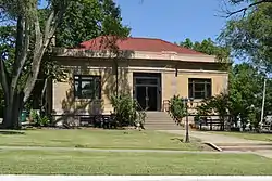 Lyndon Carnegie Library |
June 25, 1987 (#87000965) |
127 E. 6th 38°36′27″N 95°40′58″W |
Lyndon | |
| 10 | Osage City Santa Fe Depot | 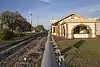 Osage City Santa Fe Depot |
May 11, 1989 (#89000386) |
508 Market 38°38′11″N 95°49′38″W |
Osage City | |
| 11 | Osage County Courthouse | 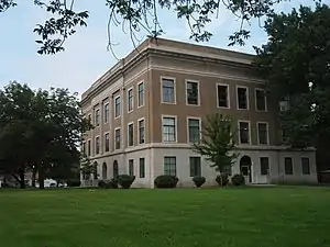 Osage County Courthouse |
April 18, 2007 (#07000320) |
717 Topeka Ave. 38°36′37″N 95°41′00″W |
Lyndon | |
| 12 | Rapp School District No. 50 | 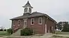 Rapp School District No. 50 |
July 28, 1995 (#95000944) |
U.S. Route 56, northwest of Osage City 38°39′07″N 95°54′46″W |
Osage City | |
| 13 | Schuyler Grade School | April 15, 2011 (#11000193) |
117 S. Dacotah St. 38°45′12″N 95°50′13″W |
Burlingame | ||
| 14 | Star Block | December 22, 2020 (#100005954) |
520 and 522 Market St. 38°38′05″N 95°49′35″W |
Osage City |
See also
| Wikimedia Commons has media related to National Register of Historic Places in Osage County, Kansas. |
References
- The latitude and longitude information provided in this table was derived originally from the National Register Information System, which has been found to be fairly accurate for about 99% of listings. Some locations in this table may have been corrected to current GPS standards.
- "National Register of Historic Places: Weekly List Actions". National Park Service, United States Department of the Interior. Retrieved on February 5, 2021.
- Numbers represent an alphabetical ordering by significant words. Various colorings, defined here, differentiate National Historic Landmarks and historic districts from other NRHP buildings, structures, sites or objects.
- "National Register Information System". National Register of Historic Places. National Park Service. March 13, 2009.
- The eight-digit number below each date is the number assigned to each location in the National Register Information System database, which can be viewed by clicking the number.

Municipalities and communities of Osage County, Kansas, United States | ||
|---|---|---|
| Cities | Map of Kansas highlighting Osage County | |
| Unincorporated communities | ||
| Townships |
| |
| Footnotes | †This populated place is designated a Census-Designated Place (CDP) by the United States Census Bureau | |
| ||
This article is issued from Wikipedia. The text is licensed under Creative Commons - Attribution - Sharealike. Additional terms may apply for the media files.