Oued Fes
The Oued Fes (Arabic: واد فاس, lit. 'River of Fes') or Fez River is a river in Morocco. It is a tributary of the Sebou River and historically the main source of water for the city of Fes, after which it is named.
The river consists of a number of different streams which originate in the Saïss Plain to the south and west of Fes before joining together in the area of Fes el-Bali, the old city (medina) of Fes.[1][2] Over the centuries the river has been split and diverted into a multitude of canals that distributed water across the city and once powered a number of historic waterwheels.[1][3] These various water channels converge into the Oued Bou Khareb which runs through the middle of the old city and historically divided the Qarawiyyin and Andalusiyyin quarters.[1] After the river leaves the city it runs eastwards for a short distance before joining the Sebou River. The various branches and sections of the river, including many of the man-made canals, also have their own names.
Description of the river
Source
The river begins at Ras al-Ma ("Head of the Water"), 12 kilometres southwest of the city, from a hollow of lacustrine limestone, with an approximate flow of 500 litres/second.[4]:131
Oued al-Jawahir
The main branch of the river skirts the northern edge of the Royal Palace grounds (the Dar al-Makhzen) and of Fes el-Jdid before entering Fes el-Bali. This section is also known as the Oued al-Jawahir (Arabic: واد الجواهر, lit. 'River of Pearls').[1] It once passed through a flat area of marshes and wetlands located near what is now Fes el-Jdid and the modern Ville Nouvelle, before emerging at a number places.[5] However, since the founding of Fes el-Jdid (13th century), the Oued al-Jawahir was progressively diverted and some of its old streams seem to have disappeared.[5] The river's flow was re-engineered to provide water for the Royal Palace complex and a succession of royal gardens such as the Mosara Gardens of the Marinids (now disappeared) and the 19th-century Jnan Sbil Gardens (still extant), before continuing towards Fes el-Bali, where it is distributed across an extensive network of man-made streams and canals which end up at the Oued Bou Khareb.[2][1]
Oued Bou Khareb
Oued Bou Khareb (or sometimes Oued el-Kbir) is the usual name given to the main urban course of the river through the middle of Fes el-Bali.[1]:122 This river is initially fed by two other streams called the Oued ez-Zitoun and the Oued Bou Fekran that enter the city from the south at Bab Jdid.[1]:234 It is also fed by the various canals that split off from the Oued al-Jawahir to supply the city before eventually ending up in this ravine in the middle of the city. As the lowest point in the medina, the river thus acts as a collector for the city's used water.[4][3]
The course of the Bou Khareb also forms the historical boundary between the Qarawiyyin and Andalus quarters of the city, which were originally two separate cities (al-'Aliya and Madinat Fas) in their early history before being joined together by the Almoravids in the 11th century.[1] Much of the Oued Bou Khareb's course, from Bab Jdid to Place R'cif, is now hidden beneath a modern road for car traffic (one of the few that penetrates the medina). The road covers the river up to Place R'cif, a large square at the heart of the medina, and the river reemerges on the north side of square.[2][1] From there the river runs northeast and exits the city between Bab Guissa and the former gate of Bab Sidi Bou Jida.[1]
The historic water network of Fes el-Bali
.png.webp)
Fes el-Bali has had access to plentiful water since its foundation.[1] The current outlines of its water supply system were begun by the Zenata emir Dunas ibn Hamama between 1037 and 1049 and then further elaborated by the Almoravid emir Yusuf ibn Tashfin between 1069 (the Almoravid conquest of Fes) and 1106.[4][3] From the west, the Oued al-Jawahir flows eastward along the northern edge of Fes el-Jdid, passing through the Bab Bou Jat Mechouar, through the Dar al-Makina (a former arms factory), and then beneath the Old Mechouar near Bab Dekkakin before reemerging on its eastern side, on the edge of the Jnan Sbil Gardens. Here it emerges from four arched openings at the bottom of the Old Mechouar's ramparts and the first major man-made division of the river take place.[4] This division creates a number of canals (many of them hidden under streets and houses) through Fes el-Bali which eventually spill back into the Oued Bou Khareb (the name of the river's main course inside the city).[4][1] There are four main historic canal divisions: the Oued Fejjalin, the Oued el-Hamiya, the Sakiyyat el-Abbasa, and the Oued Shrashar.[1] Most of these then split off into other canals as they progress through the city.
The Oued Fejjalin is one of the most important divisions and from it the Oued el-Lemtiyyin also splits off to supply the northernmost parts of the city.[4][1] The Oued el-Lemtiyyin passes under the Bou Jeloud area and travels under the houses of Tala'a Kebira street until it reaches the Bou Inania Madrasa.[4] Here, in the vicinity of the madrasa, the water is collected by a large distributor structure made of brick and rammed and dating from the Almoravid period. This structure has three arched openings that lead into vaulted chambers from which the water emerges on the other side into three canals at different elevations, which then spread across different parts of the northern city.[4][3]
As for the Oued el-Hamiya, it splits from the other major branches at Jnan Sbil before dividing into more branches which mostly supply the southern parts of the city.[4] One of its branches also once supplied, via an aqueduct, the Andalus quarter on the opposite shore of the Bou Khareb river.[1] The two last branches, Sakiyyat al-Abbasa and the Oued Shrashar, supplied the regions near Bab al-Hadid and the gardens between Fes el-Jdid and Fes el-Bali.[1]
In addition to this western network of canals coming from the Oued al-Jawahir, the streams to the south of the city (which also formed the beginning of the Bou Khareb River) fed an entirely separate but important canal called the Oued Masmuda.[1] This canal, further east, supplied water for most of the Andalus quarter of Fes on the southeast side of the Bou Khareb river.[1][4] It begins to the south of the city and passed through the old city walls through a culvert opening called Bab ash-Shobbak ("Gate of the Window") which was protected by an iron grille.[4][1] A few other canals split from it as it wound its way through the district, until it finally rejoined the Bou Khareb river shortly before its exit from the city.[1][4] The canal appears to be named after the Masmuda Berber tribal confederacy that founded the Almohad movement, which suggests that it might have been constructed by the Almohads or that Masmuda families or troops were housed near it at some point.[1]:113
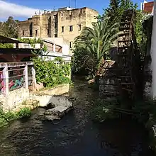
Many of these historic canals are now underground, with only some ancient toponyms hinting at former bridges that passed over them (e.g. the name Qantrat Bou Rous along a part of Tala'a Kebira).[1] These canals and streams also feed a number of industries such as the historic tanneries of the city, the most famous of which are the Chouara Tanneries.[1] A large number of waterwheels (known as norias or sometimes as saqiyyas) were located throughout the city's water network in order to assist in water distribution or to power certain industries.[1][4] Some of these were very large, such as the huge noria which supplied the Marinid royal gardens of Mosara, measuring 26 meters in diameter and 2 meters in thickness.[2] Only a few of these waterwheels have survived in some form, including some examples around the Jnan Sbil Gardens.[1][3]
Historic bridges over the Oued Bou Khareb
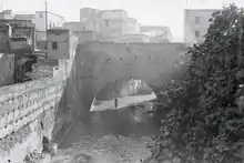
The Oued Bou Khareb is crossed by several historic bridges inside the medina, some of which were first built before the unification of the two shores into a single city in the 11th century.[6] There were once at least six bridges, reportedly built by the Zenata emir Dunas ibn Hamama in the early 11th century, before the unification of the two cities by the Almoravids later in the same century.[7][1][6] Other scholarly sources, however, attribute at least some of the bridges to the Almoravid period (late 11th to early 12th centuries) when the two early cities of Fes were unified.[3] Many of them were destroyed in subsequent floods in the early 14th century, and only some of them were rebuilt by the Marinid Sultan Abu Sa'id at the time.[7]
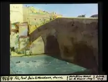
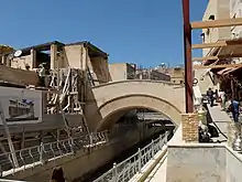
Of the bridges that remain today, the Qantra Bin el-Moudoun ("Bridge Between the Two Cities") is the northernmost of them, followed to the south by the Qantrat Sebbaghin ("Bridge of the Tanners") and by the Qantrat Terrafin ("Bridge of the Cobblers") just north of Place R'cif. Another bridge, the Bridge of Sidi al-'Awwad, was located further south but likely disappeared during the 20th century when the river was covered by the modern paved road.[1] The Bin el-Moudoun Bridge, believed to date from the time of Emir Dunas ibn Hamama, was considered one of the most picturesque, being located amidst a stretch of rocky rapids.[5][7] It has a span composed of three arches but only the central one is still visible today.[3] The Sebbaghin Bridge, also known as the Khrashfiyin Bridge (or Khrachfiyine in the French transliteration), is believed to have been originally built by Emir Dunas and restored or rebuilt by the Marinids in the 14th century.[6][7] The Terrafin bridge, originally named Qantrat Bab al-Silsila and now found on the northern edge of Place R'cif, is also believed to date initially from Emir Dunas in the 11th century.[6][3][7] It is notable for having been lined with shops on both sides, a feature still partly visible in its structure today.[3][1]
Pollution problems and rehabilitation efforts
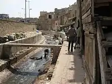
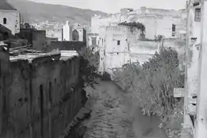
The river, particularly the Oued Bou Khareb within the old medina, has long suffered from heavy pollution due to sewage, the activities of the nearby tanneries (which generate chemical waste), and to being sometimes used as a dumping ground by residents.[8][9] Even the name Oued Bou Khareb means "River of Trash".[1][8] The increase in pollution in modern times led to locals building walls and concrete barriers to block out the smell of the river, and more recently the city authorities had begun covering the exposed parts of the river with concrete slabs, which only led to more garbage piling up on top of this.[9][10] The waste of the tanning industry and other activities also led to toxic chemicals, particularly high levels of Chromium, accumulating in the soil and the water.[10] Although it is believed that this does not affect the city's drinking water (which comes from upstream), it creates problems for sites downstream along the Sebou River following its confluence with the Oued Fes.[11][12]
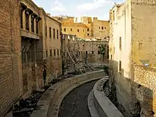
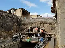
In the late 2000s, a large-scale project to rehabilitate the river system and its urban environment was begun. The project, led by architect Aziza Chaouni, included the cleaning up of the river, the renovation of its urban shoreline, the creation of open pedestrian walkways, and the renovation of existing open spaces along the river such Place R'cif and Place Lalla Yeddouna.[8][9][13] The proposal to improve water quality also included the creation of wetlands (which had previously existed along the river's course) and the restoration of the river's canals.[9] At one point the project had also proposed to end or curtail the operations of the Chouara Tanneries and relocate the tanning industry elsewhere where its pollution could be managed more safely,[14][15] but in the end the tanneries were restored and left in place.[16]
The rehabilitation of the river, which has been underway since, also took place alongside broader efforts to restore the historical monuments and landmarks of the old city, mostly under the direction of the local heritage restoration agency ADER-Fes. This included the restoration of the bridges over the Bou Khareb river, with the Terrafin and Sebbaghin/Khrashfiyin bridges being restored in the 2010s.[6]
References
| Wikimedia Commons has media related to Oued Bou Khareb. |
- Le Tourneau, Roger (1949). Fès avant le protectorat: étude économique et sociale d'une ville de l'occident musulman. Casablanca: Société Marocaine de Librairie et d'Édition.
- Métalsi, Mohamed (2003). Fès: La ville essentielle. Paris: ACR Édition Internationale. ISBN 978-2867701528.
- Marcos Cobaleda, Maria; Villalba Sola, Dolores (2018). "Transformations in medieval Fez: Almoravid hydraulic system and changes in the Almohad walls". The Journal of North African Studies. 23 (4): 591–623.
- Madani, Tariq (1999). "Le réseau hydraulique de la ville de Fès". Archéologie islamique. 8–9: 119–142.
- Gaudio, Attilio (1982). Fès: Joyau de la civilisation islamique. Paris: Les Presse de l'UNESCO: Nouvelles Éditions Latines. ISBN 2723301591.
- "La magnifique rénovation des 27 monuments de Fès – Conseil Régional du Tourisme (CRT) de Fès" (in French). Retrieved 2020-03-31.
- Gaillard, Henri (1905). Une ville de l'Islam: Fès. Paris: J. André. pp. 32.
- "Revitalization of the Fez River: A Reclaimed Public Space | Smart Cities Dive". www.smartcitiesdive.com. Retrieved 2020-03-31.
- "Morocco.com | The Rejuvenation of the Fez River". www.morocco.com. Retrieved 2020-03-31.
- "A jewel of the city: Aziza Chaouni on restoring the Fez River". TED Blog. 2014-04-04. Retrieved 2020-09-15.
- International, Living on Earth / World Media Foundation / Public Radio (October 2014). "Living on Earth: Fascinating & Toxic - Traditional Moroccan Tanneries". Living on Earth. Retrieved 2020-09-15.
- Es-Sette, B.; Ajdor, Y.; Zidane, F.; Fakhraddine, A.; Foutlane, A. (2005). "Modèle conceptuel de transport de métaux traces (chrome et nickel) dans l'Oued Sebou Maroc". Environmental Technology. 26: 831–841.
- "Aziza Chaouni presents a 2014 TED Talk on her efforts to uncover the Fez River in Morocco". Daniels. 2014-03-20. Retrieved 2020-03-31.
- "https://www.architectmagazine.com/awards/p-a-awards/aziza-chaouni_o". www.architectmagazine.com. Retrieved 2020-09-15. External link in
|title=(help) - "THE VIEW FROM FEZ: The Fez Tanneries - Aziza Chaouni responds". THE VIEW FROM FEZ. 2008-12-21. Retrieved 2020-09-15.
- "THE VIEW FROM FEZ: The Famous Fez Chouara Tannery Gets a Makeover". THE VIEW FROM FEZ. 2016-02-27. Retrieved 2020-09-15.