Over Stratton
Over Stratton is a small village in the district of South Somerset, Somerset, England. It is part of the parish of South Petherton along with the nearby hamlets of Lower Stratton, Wigborough, Yeabridge and Watergore. As of census day 2011, the population was 317.[1]
| Over Stratton | |
|---|---|
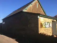 Stratton and District Village Hall | |
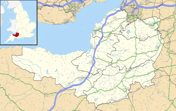 Over Stratton Location within Somerset | |
| Population | 317 [1] |
| OS grid reference | ST435151 |
| District | |
| Shire county | |
| Region | |
| Country | England |
| Sovereign state | United Kingdom |
| Post town | SOUTH PETHERTON |
| Postcode district | TA13 |
| Dialling code | 01460 |
| Police | Avon and Somerset |
| Fire | Devon and Somerset |
| Ambulance | South Western |
| UK Parliament | |
Towards the north end of the village, Stratton & District Village Hall[2] provides an amenity for the local residents and hosts clubs dedicated to interests such as gardening, folk dancing and yoga. It also hosts a nursery[3] for pre-school age children.
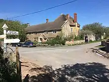
In the centre of the village there are two hospitality-related businesses: a public house with a restaurant (the Royal Oak[4]) and a restaurant that also has rooms for bed and breakfast (New Farm[5]). A third hospitality-related enterprise is situated at the southern edge of the village on the road to Merriott. It holds occasional feasts, approximately once a month.[6]
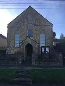
The village also has a Methodist church but services are no longer held there.
History
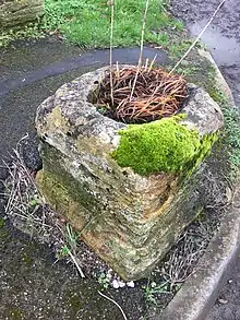
The South Petherton Local History Group[7] has published a booklet titled "Explore South Petherton's Past"[8] that contains a number of references to Over Stratton, particularly on pages 32 and 33. These include the Church Room (now the village hall) built in 1865, the Fosse Way, a farmhouse (now the Royal Oak Inn), a raised pavement, the Methodist church, a socket-stone, Stratton Farm and West End House.
There are numerous reference to Over Stratton and the other settlements forming part of the parish of South Petherton in "A History of the County of Somerset."[9]
Historic England [10]has nine entries of Class II listed items: "West End House; Barn, about 15 meters north west of West End House; East boundary wall and gateways to West End House; Old Harp House; Socket Stone of Wayside Cross (at the junction of South Harp, Lopen Lane and Bull Bridge Lane); Stratton Farmhouse; Royal Oak Inn; Herontye and Hollands Orchard; House about 70 meters north of Royal Oak Inn, and coach house to east."
Geography
The village sits on sandstone, the Bridport Sand Formation, a sedimentary bedrock formed approximately 174 to 183 million years ago in the Jurassic Period.[11] Locally, it is also known as Yeovil Sandstone. In parts of the village the bedrock is overlain by clay deposits. According to the Agricultural Land Classification Map South West Region (ALC006),[12] Over Stratton is located on class 1 (excellent) agricultural land. As such it is “Land with no or very minor limitations. A very wide range of agricultural and horticultural crops can be grown and commonly includes: top fruit, soft fruit, salad crops and winter harvested vegetables. Yields are high and less variable than on land of lower quality.” Ordnance Survey maps from the nineteenth and early twentieth centuries show a number of apple orchards in and around the village. Most of the orchards within the village boundary have been subject to residential development in the second half of the twentieth century. .
Many of the older buildings were built using Hamstone from nearby Ham Hill quarries. It is a honey-coloured Jurassic limestone.
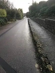
The principal street runs north-south through the village and is un-named although some local government organizations refer to it as "Over Stratton Road, South Petherton", for example, when publishing temporary road closure orders. The route of Roman road, the Fosse Way, crosses this street in a northeast southwest direction. The route of the Fosse Way is joined by the A303 2 km northeast of the village, close to Petherton Bridge over the River Parrett. Some of the minor streets joining the principal streets are named but none of the streets other than Church Path and Gorefield have a numbering system for the properties. On the village noticeboard there is an outline map that includes an indexed list of 143 properties and their corresponding locations on the map.
There are 10 post codes [13] covering the village and the immediate vicinity:
| Post code | Street name | Description |
|---|---|---|
| TA13 5LB | Lopen Lane | road to Lopen |
| TA13 5LB | Bull Bridge Lane | road to Merriott |
| TA13 5LD | South Harp | Swedish Houses |
| TA13 5LE | South Harp | Airey houses |
| TA13 5LF | South Harp | road to Lower Stratton |
| TA13 5LG | - | southern end of main street |
| TA13 5LH | Harp Road | Watergore |
| TA13 5LJ | Northfield Lane | Northfield Lane |
| TA13 5LL | - | northern end of main street |
| TA13 5LL | Gorefield | northern end of main street |
| TA13 5LN | Church Path | northern end of main street, closest to Watergore |
| TA13 5LQ | - | central main street |
| TA13 5LP | Wigborough | and parts of Lower Stratton |
| TA13 5LW | Yeabridge | |
| TA13 5FH | Lower Stratton | including Yeabridge Court |
Transport
The village lies south of the A303 trunk road so it has excellent road transport links to east and west. On the former route of the old A303 on Harp Road, there is a fuel station by which there are bus stops for local services to South Petherton and Yeovil, and express services to Taunton and Hammersmith, London. The nearest railway station is at Crewkerne, five miles to the south of the village.
Nearby hamlets
Yeabridge
The hamlet of Yeabridge lies approximately 0.5 miles north of Lower Stratton, along Yeabridge Lane, and gives its name to postal addresses in Lower Stratton and Wigborough.
Lower Stratton and Wigborough
Lower Stratton is approximately one mile south of the Hayes End Roundabout on the A303 at the soutern end of Yeabridge Lane. It is also approximately 0.5 miles east of the village of Over Stratton along South Harp. A third road, Creedy Bridge Road, exits Lower Stratton, initially heading northwards then turning eastwards, past Pound, over the Creedy Bridge towards Norton-sub-Hamdon. Lower Stratton is contiguous with Wigborough, another hamlet in the parish of South Petherton.
Somewhat confusingly, the Yeabridge Farm[14] complex of buildings is located in Lower Stratton. The farm is the commercial hub of the hamlet and has diversified into glamping, a 50kW solar photovoltaic array and secure storage. It also hosts a business specializing in the sale and maintenance of agricultural equipment. South Somerset District Council granted planning permission[15] to convert the original Hamstone farm buildings into 11 residential units. These buildings have been replaced by constructing new buildings at the southern end of Little Lopen Lane.[16]
In Wigborough, the most notable building is Wigborough Manor House,[17] just east of Lower Stratton along Wigborough Manor Lane. Wigborough Manor House is the home of the Vaux Park Polo Club.[18]
References
- UK Census (2011). "Local Area Report – Over Stratton Built-up area sub division (E35001643)". Nomis. Office for National Statistics. Retrieved 20 August 2020.
- http://www.southpethertonparishcouncil.gov.uk/Over-Stratton-Hall.aspx
- Sunshine Nursery https://www.montessori.org.uk/school/sunshine-morning-nursery
- https://www.royaloakoverstratton.co.uk/
- https://www.newfarmrestaurant.co.uk/
- http://www.thepigpen.net/
- http://www.southpetherton.online/Local-Information/Local-Groups/Local-Groups.html
- Explore South Petherton's Past, South Petherton Local History Group, rev November 2014
- A History of the County of Somerset: Volume 4, pp170-198<https://www.british-history.ac.uk/vch/som/vol4/pp170-198>
- https://historicengland.org.uk/listing/the-list Retrieved 8 October 2020/
- http://mapapps.bgs.ac.uk/geologyofbritain/home.html
- http://publications.naturalengland.org.uk/publication/144017?category=5954148537204736
- https://m.royalmail.com/mt/www.royalmail.com/find-a-postcode
- https://www.yeabridge.farm/
- https://publicaccess.southsomerset.gov.uk/online-applications/applicationDetails.do?keyVal=P7URB4OWN5400&activeTab=summary
- https://publicaccess.southsomerset.gov.uk/online-applications/applicationDetails.do?activeTab=summary&keyVal=NY2LXEOWJRG00
- "Wigborough Manor House" . https://historicengland.org.uk/listing/the-list/list-entry/1056928
- "Vaux Park Polo Club" http://www.vauxparkpoloclub.co.uk/