Overijssel
Overijssel (/ˌoʊvərˈaɪsəl/ OH-vər-EYE-səl, Dutch: [ˌoːvərˈɛisəl] (![]() listen); Low German: Oaveriessel [ˌɒːvərˈiːsəl]; German: Oberyssel) is a province of the Netherlands located in the eastern part of the country. The province's name translates to "across the IJssel", from the perspective of the Episcopal principality of Utrecht by which it was held until 1528. The capital city of Overijssel is Zwolle (pop. 127,497[4]) and the largest city is Enschede (pop. 158,986). The province had a population of 1,162,215 as of November 2019.
listen); Low German: Oaveriessel [ˌɒːvərˈiːsəl]; German: Oberyssel) is a province of the Netherlands located in the eastern part of the country. The province's name translates to "across the IJssel", from the perspective of the Episcopal principality of Utrecht by which it was held until 1528. The capital city of Overijssel is Zwolle (pop. 127,497[4]) and the largest city is Enschede (pop. 158,986). The province had a population of 1,162,215 as of November 2019.
Overijssel | |
|---|---|
 Coat of arms | |
| Anthem: "Aan de rand van Hollands gouwen" "On the edge of Holland's district" | |
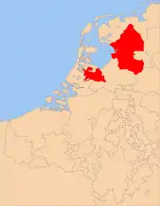
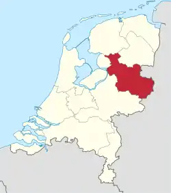 Location of Overijssel in the Netherlands | |
| Country | Netherlands |
| Capital | Zwolle |
| Largest city | Enschede |
| Government | |
| • King's Commissioner | Lenard Horstede (CU) |
| Area (2017)[1] | |
| • Total | 3,421 km2 (1,321 sq mi) |
| • Land | 3,323 km2 (1,283 sq mi) |
| • Water | 98 km2 (38 sq mi) |
| Area rank | 5th |
| Population (1 November 2019)[2] | |
| • Total | 1,162,215 |
| • Rank | 6th |
| • Density | 350/km2 (900/sq mi) |
| • Density rank | 7th |
| ISO 3166 code | NL-OV |
| Religion (2006) | Protestant 29% Catholic 26% Muslim 2% Others 6% Non-religious 37% |
| HDI (2018) | 0.921[3] very high · 7th |
| Website | www.overijssel.nl |
Geography
Overijssel is bordered by Germany (Lower Saxony and North Rhine-Westphalia) to the east, the Achterhoek region of Gelderland to the south, the Veluwe region of Gelderland and Flevoland to the west, and Friesland and the former moors of Drenthe to the north. Overijssel comprises three regions: Kop van Overijssel in the northwest, Salland in the centre of the province, and Twente in the east. Besides the capital Zwolle, other major cities are Almelo, Deventer, Enschede, and Hengelo.
To the southeast, the province's surface is mostly sandy, interspersed with small rivers such as the Regge and Dinkel and other brooks. In the northwest, the geology is dominated by sediments from the Overijsselse Vecht and clay. The northern parts were once covered by veen (bogs) which separated the dryer and more arable south from Drenthe and which have been exploited as fuel to a large degree. Only small patches survive today (Engbertsdijksvenen near Geesteren, Witteveen (near Haaksbergen), and the Aamsveen (near Enschede). The extreme northwest is dominated by a system of lakes formed by former peat-mining and protected under the De Weerribben-Wieden National Park status, which is a valuable wetland.
The highest point in Overijssel is the summit of the Tankenberg, a hill in the municipality of Losser, at 85 metres (278 ft). The lowest point is in the Mastenbroek Polder near Kampen at 2 metres (6 ft) below sea level.
Climate
Overijssel enjoys an oceanic climate (Cfb in the Köppen classification). However, winters tend to be more severe than the rest of the Netherlands, because of its distance from the coast.[5]
| Climate data for Twenthe (1981-2010) | |||||||||||||
|---|---|---|---|---|---|---|---|---|---|---|---|---|---|
| Month | Jan | Feb | Mar | Apr | May | Jun | Jul | Aug | Sep | Oct | Nov | Dec | Year |
| Average high °C (°F) | 4.8 (40.6) |
5.7 (42.3) |
9.5 (49.1) |
13.9 (57.0) |
18.0 (64.4) |
20.5 (68.9) |
22.8 (73.0) |
22.5 (72.5) |
18.7 (65.7) |
14.1 (57.4) |
8.9 (48.0) |
5.2 (41.4) |
13.7 (56.7) |
| Daily mean °C (°F) | 2.3 (36.1) |
2.6 (36.7) |
5.6 (42.1) |
8.9 (48.0) |
12.9 (55.2) |
15.4 (59.7) |
17.6 (63.7) |
17.1 (62.8) |
14.0 (57.2) |
10.2 (50.4) |
6.0 (42.8) |
2.9 (37.2) |
9.6 (49.3) |
| Average low °C (°F) | −0.5 (31.1) |
−0.6 (30.9) |
1.5 (34.7) |
3.4 (38.1) |
7.1 (44.8) |
9.6 (49.3) |
12.0 (53.6) |
11.5 (52.7) |
9.2 (48.6) |
6.2 (43.2) |
3.0 (37.4) |
0.3 (32.5) |
5.2 (41.4) |
| Average precipitation mm (inches) | 71.5 (2.81) |
51.6 (2.03) |
65.1 (2.56) |
45.2 (1.78) |
62.4 (2.46) |
67.7 (2.67) |
74.5 (2.93) |
71.0 (2.80) |
65.4 (2.57) |
67.5 (2.66) |
68.9 (2.71) |
74.1 (2.92) |
784.9 (30.90) |
| Mean monthly sunshine hours | 52.8 | 82.6 | 114.0 | 169.9 | 202.1 | 184.6 | 202.4 | 184.4 | 137.4 | 112.3 | 58.9 | 46.0 | 1,547.3 |
| Source: KNMI [6] | |||||||||||||
History
Oversticht
Overijssel was formerly known as Oversticht and also included most of the modern-day province of Drenthe. In 1336, it was made part of Guelders, though it was ceded to the Bishopric of Utrecht in 1347. The Bishops ceded the Oversticht to the Emperor Charles V in 1528, who styled himself Lord of Overijssel, after the Latin name of Oversticht that was known since 1233: Transysla or Transisalania, or Over-IJssel, i.e. the other side of the river IJssel. The people joined with the other Dutch and rebelled against Charles' heir Philip II. Overijssel became governed by the most powerful mayors and lords in the province, including by the lieutenant-governor Nicolaas Schmelzing (1561-1629).
After a brief occupation by the forces of the Bishop of Münster (1672–74), Overijssel received a new form of government which granted the stadtholders more power. Widespread resistance against the increased power throughout the provinces eventually led to the formation of the Batavian Republic in 1795. A centralist government arose and the Netherlands was organised into a series of départements, based on those used by revolutionary France.
Overijssel
At first organised into its own département, it was merged with Drenthe in 1798 to form Ouden IJssel, which was renamed Overijssel in 1801.
The French annexed the Batavian Republic in 1810, and Overijssel was organised into the new French département of Bouches-de-l'Yssel. After the defeat of Napoleon in 1814, the kingdom of the Netherlands and the former province of Overijssel were recreated.
Overijssel was occupied by Nazi Germany during World War II from May 1940 until its liberation in April 1945. The Noordoostpolder, a reclaimed territory which had been laid dry in 1942, was part of Overijssel from 1962 until 1986, when it became part of the newly created province of Flevoland.
Politics
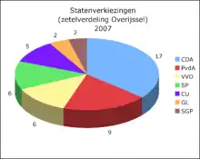
The King's Commissioner of Overijssel is currently a vacant position as previous title holder Ank Bijleveld (CDA) was appointed to be Minister of defence on 26 October 2017. The King's Commissioner is the chairman of the Provincial-Executive (executive branch) and the States-Provincial (elected legislature) of the province.
| 2015 election results | ||
|---|---|---|
| Political party | Votes in % | Seats |
| Christian Democratic Appeal | 22.44 | 11 |
| People's Party for Freedom and Democracy | 12.43 | 6 |
| Socialist Party | 10.70 | 5 |
| Labour Party | 10.59 | 5 |
| Democrats 66 | 10.47 | 5 |
| Party for Freedom | 9.43 | 5 |
| Christian Union | 8.37 | 4 |
| Reformed Political Party | 4.31 | 2 |
| GroenLinks | 4.30 | 2 |
| 50PLUS | 2.91 | 1 |
| Party for the Animals | 2.24 | 1 |
| Other parties | 0.66 | 0 |
| Total | 47 | |
Economy
The Gross domestic product (GDP) of the region was 43.2 billion € in 2018, accounting for 5.6% of the Netherlands economic output. GDP per capita adjusted for purchasing power was 32,700 € or 108% of the EU27 average in the same year.[7]
Transport
There are three main motorways in Overijssel, the A1, A28, and the A35. The A32 also runs through the province, but just for a few kilometers near Steenwijk.[8]
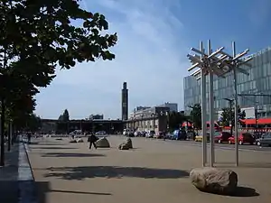
The main railway station in Overijssel is the Zwolle railway station, located in the city of Zwolle which serves as hub between the northern provinces and the rest of The Netherlands.
The main airport in Overijssel is the Enschede Airport Twente, located outside of Enschede. The airport does not currently offer any international flights, though it has historically.[9]
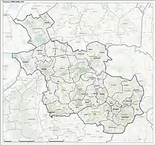
Municipalities
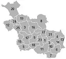
Overijssel is divided into 25 municipalities:
- North Overijssel COROP group
- Dalfsen (3)
- Hardenberg (8)
- Kampen (12)
- Ommen (16)
- Staphorst (19)
- Steenwijkerland (20)
- Zwartewaterland (24)
- Zwolle (25)
- South West Overijssel COROP group
- Deventer (5)
- Olst-Wijhe (15)
- Raalte (17)
- Twente COROP group
- Almelo (1)
- Borne (2)
- Dinkelland (4)
- Enschede (6)
- Haaksbergen (7)
- Hellendoorn (9)
- Hengelo (10)
- Hof van Twente (11)
- Losser (13)
- Oldenzaal (14)
- Rijssen-Holten (18)
- Tubbergen (21)
- Twenterand (22)
- Wierden (23)
See also
- Overisel Township, Michigan, US was named after Overijssel
- Tanfana
References
- http://www.waarstaatjeprovincie.nl/Paginas/Ruimtelijke%20ordening/Oppervlakte.aspx
- https://opendata.cbs.nl/statline/#/CBS/nl/dataset/37230ned/table
- "Sub-national HDI - Area Database - Global Data Lab". hdi.globaldatalab.org. Retrieved 2018-09-13.
- https://opendata.cbs.nl/statline/#/CBS/nl/dataset/70072ned/table
- "Overijssel climate info | what's the weather like in Overijssel, the Netherlands".
- "Twenthe, long-term averages, time period 1981-2010 (in Dutch)" (PDF). Retrieved December 29, 2012.
- "Regional GDP per capita ranged from 30% to 263% of the EU average in 2018". Eurostat.
- "Category:Overijssel - Hitchwiki: The Hitchhiker's guide to Hitchhiking".
- "Airports in Overijssel, Netherlands @ OurAirports".
External links
| Wikimedia Commons has media related to Overijssel. |
- Official website
- Participation platform of Overijssel
 Overijssel travel guide from Wikivoyage
Municipalities of Overijssel | ||
|---|---|---|
 | ||
| ||
| ||
 | ||
| Authority control |
|---|