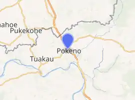
Pōkeno
Pōkeno is a small town (615 households)[2] in the Waikato District of the Waikato region in New Zealand, 53 km (33 mi) southeast of Auckland, 9 km (5.6 mi) from Tuakau and 5 km (3.1 mi) from Mercer. State Highway 1 originally ran through the town, but the upgrading of the highway in 1992 to expressway standards mean that the town has been bypassed.[3]
Pōkeno | |
|---|---|
Town | |
 Queen's Redoubt rampart | |
| |
| Coordinates: 37°14′S 175°01′E | |
| Country | New Zealand |
| Region | Waikato |
| District | Waikato District |
| Elevation | 40 m (130 ft) |
| Population (June 2020)[1] | |
| • Territorial | 4,020 |
| Time zone | UTC+12 (NZST) |
| • Summer (DST) | UTC+13 (NZDT) |
| Postcode | 2402 |
| Area code(s) | 09 |

Alexander Turnbull Library, Wellington.
http://natlib.govt.nz/records/22539250
History
The town is named for the Ngāti Tamaoho settlement in the area called Pokino, located to the northwest of the current town centre.[4] A military installation, Pokino Camp, was set up in the area in December 1861 after Governor George Edward Grey called for a road to be completed from Drury to the Waikato River, Great South Road.[4] In mid-1862, work began on Queen's Redoubt, a military base which would become General Cameron's base of operations for the Invasion of the Waikato, housing 450 soldiers.[4][5] The Māori village of Pokino to the north of Queen's Redoubt was deserted in July 1863 just prior to the start of the invasion (officially the village was listed as abandoned, though likely it had been ransacked by unauthorised soldiers).[4] Queen's Redoubt was abandoned for military use in March 1867, with the buildings of the redoubt sold off by auction soon after.[4]
The Pokeno Railway Station on the Waikato section of the North Island Main Trunk line was opened in 1875, but was closed in 1973 to passengers and in 1980 to goods. Work on the proposed Paeroa–Pokeno Line commenced in 1938 and whilst approximately 13 km of earthworks were completed at each end, the proposal was halted due to World War 2 and was not resumed following the war and was abandoned.
Construction of a large Yashili dairy factory started in 2013,[6] but opening was delayed in 2015.[7]
Demographics
| Year | Pop. | ±% p.a. |
|---|---|---|
| 2006 | 570 | — |
| 2013 | 600 | +0.74% |
| 2018 | 2,517 | +33.21% |
| Source: [8] | ||
Pōkeno had a population of 2,517 at the 2018 New Zealand census, an increase of 1,917 people (319.5%) since the 2013 census, and an increase of 1,947 people (341.6%) since the 2006 census. There were 792 households. There were 1,278 males and 1,239 females, giving a sex ratio of 1.03 males per female. The median age was 33.8 years, with 588 people (23.4%) aged under 15 years, 459 (18.2%) aged 15 to 29, 1,263 (50.2%) aged 30 to 64, and 207 (8.2%) aged 65 or older.
Ethnicities were 68.7% European/Pākehā, 15.6% Māori, 4.3% Pacific peoples, 20.9% Asian, and 3.5% other ethnicities (totals add to more than 100% since people could identify with multiple ethnicities).
The proportion of people born overseas was 34.7%, compared with 27.1% nationally.
Although some people objected to giving their religion, 44.8% had no religion, 34.4% were Christian, 6.1% were Hindu, 1.1% were Muslim, 1.2% were Buddhist and 5.5% had other religions.
Of those at least 15 years old, 471 (24.4%) people had a bachelor or higher degree, and 273 (14.2%) people had no formal qualifications. The median income was $46,800. The employment status of those at least 15 was that 1,206 (62.5%) people were employed full-time, 231 (12.0%) were part-time, and 60 (3.1%) were unemployed.[8]
Rural surrounds
| Year | Pop. | ±% p.a. |
|---|---|---|
| 2006 | 1,263 | — |
| 2013 | 1,377 | +1.24% |
| 2018 | 1,668 | +3.91% |
| Source: [9] | ||
The statistical area of Pōkeno Rural, which covers 89 square kilometres around Pōkeno including Mercer, had a population of 1,668 at the 2018 New Zealand census, an increase of 291 people (21.1%) since the 2013 census, and an increase of 405 people (32.1%) since the 2006 census. There were 564 households. There were 834 males and 831 females, giving a sex ratio of 1.0 males per female. The median age was 41.8 years, with 342 people (20.5%) aged under 15 years, 261 (15.6%) aged 15 to 29, 846 (50.7%) aged 30 to 64, and 216 (12.9%) aged 65 or older.
Ethnicities were 86.3% European/Pākehā, 14.7% Māori, 4.0% Pacific peoples, 5.6% Asian, and 2.3% other ethnicities (totals add to more than 100% since people could identify with multiple ethnicities).
The proportion of people born overseas was 18.7%, compared with 27.1% nationally.
Although some people objected to giving their religion, 57.4% had no religion, 32.6% were Christian, 0.4% were Hindu, 0.2% were Muslim, 0.4% were Buddhist and 2.2% had other religions.
Of those at least 15 years old, 210 (15.8%) people had a bachelor or higher degree, and 249 (18.8%) people had no formal qualifications. The median income was $43,100. The employment status of those at least 15 was that 798 (60.2%) people were employed full-time, 183 (13.8%) were part-time, and 33 (2.5%) were unemployed.[9]
Education
.jpg.webp)
Pokeno School is a co-educational state full primary school (years 1–8)[10][11] with a roll of 331 as of March 2020.[12] Three schools were established in the area in the 19th century: Pokeno Hill School in 1866, a school at Pokeno Redoubt in 1870, and Pokeno Valley School in 1878. The first two schools closed in 1888-89. In 1961, the Pokeno Valley School was replaced by the current school.[13][14]
In popular culture
- In the New Zealand film Goodbye Pork Pie, the fugitives steal fuel from the Pōkeno service station, now operating as a mobile home sales yard.
- Pōkeno is well known for its two competing ice cream shops, situated on the main road, where pricing and generous scoops have created almost a cult following.[15]
- The former Thompson Twins member Alannah Currie, who was born in Auckland, now works as an artist under the name Miss Pokeno.[16]
References
- "Population estimate tables - NZ.Stat". Statistics New Zealand. Retrieved 22 October 2020.
- "2013 census interactive map - select Area Unit, type Pokeno and click". Archived from the original on 22 August 2015. Retrieved 5 September 2015.
- "Pokeno". Retrieved 12 October 2010.
- Prickett, Nigel (2003). "THE HISTORY AND ARCHAEOLOGY OF QUEEN'S REDOUBT, SOUTH AUCKLAND". Records of the Auckland Museum. 40: 5–37. ISSN 1174-9202.
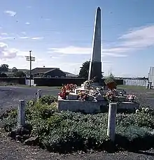
- "Pokeno NZ Wars memorial". New Zealand History online. Retrieved 12 October 2010.
- [23 Sept 2013 Stuff news of start of construction of dairy plant]
- 18 August 2015 Stuff news on Yashili dairy plant
- "Statistical area 1 dataset for 2018 Census". Statistics New Zealand. March 2020. Pōkeno (170500). 2018 Census place summary: Pōkeno
- "Statistical area 1 dataset for 2018 Census". Statistics New Zealand. March 2020. Pōkeno Rural (170200). 2018 Census place summary: Pōkeno Rural
- "Official School Website". pokeno.school.nz.
- "Ministry of Education School Profile". educationcounts.govt.nz. Ministry of Education.
- "Education Review Office Report". ero.govt.nz. Education Review Office.
- "Historic Overview -Pokeno & District" (PDF). Waikato District Council. p. 51.
- Pokeno School 1866-1961 : jubilee reunion and official opening of the new school : April 21st, 22nd, 23rd. Pokeno School. 1961.
- Park, Nicky (3 January 2015). "Five of the Best: Ice Cream Shops". NZ Herald. Retrieved 18 January 2016.
- "Alannah Currie - Miss Pokeno - Sisters of Perpetual Resistance".
External links
- "Pokeno in Cyclopaedia of New Zealand (1902)". NZETC. 1 December 2015.
