Paka, Dobrepolje
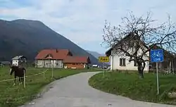
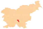
Paka (pronounced [ˈpaːka]) is a small settlement in the Municipality of Dobrepolje in Slovenia. The area is part of the historical region of Lower Carniola. The municipality is now included in the Central Slovenia Statistical Region.[2]
Paka | |
|---|---|
 | |
 Paka Location in Slovenia | |
| Coordinates: 45°46′49.77″N 14°46′18.2″E | |
| Country | |
| Traditional region | Lower Carniola |
| Statistical region | Central Slovenia |
| Municipality | Dobrepolje |
| Area | |
| • Total | 0.11 km2 (0.04 sq mi) |
| Elevation | 417 m (1,368 ft) |
| Population (2002) | |
| • Total | 34 |
| [1] | |
Name
The name Paka is a relatively common hydronym (cf. the Paka River) and toponym in Slovenia. As a hydronym, the designation comes from Slavic *paka (voda) 'water flowing the wrong/opposite direction', and some settlements named Paka are derived from their location near such watercourses. However, the toponym Paka may also be derived from the Slovene common noun paka 'rise, elevation', referring to settlements in such a location.[3]
Cultural heritage
A small chapel-shrine in the settlement is dedicated to the Sacred Heart of Jesus and dates to the early 20th century.[4]
References
- Statistical Office of the Republic of Slovenia
- Dobrepolje municipal site
- Snoj, Marko. 2009. Etimološki slovar slovenskih zemljepisnih imen. Ljubljana: Modrijan and Založba ZRC, pp. 299–300.
- "EŠD 14952". Registry of Immovable Cultural Heritage (in Slovenian). Ministry of Culture of the Republic of Slovenia. Retrieved 1 March 2011.
External links
| Settlements | Administrative centre: Videm
|  | ||||
|---|---|---|---|---|---|---|
| Landmarks |
| |||||
| Notable people |
| |||||