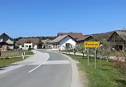
Ponikve, Dobrepolje
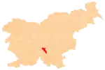
Ponikve (pronounced [pɔˈniːkʋɛ]; German: Ponique[2]) is a settlement in the Municipality of Dobrepolje in Slovenia. The area is part of the historical region of Lower Carniola. The municipality is now included in the Central Slovenia Statistical Region.[3]
Ponikve | |
|---|---|
 | |
 Ponikve Location in Slovenia | |
| Coordinates: 45°51′42.82″N 14°39′5.83″E | |
| Country | |
| Traditional region | Lower Carniola |
| Statistical region | Central Slovenia |
| Municipality | Dobrepolje |
| Area | |
| • Total | 7.36 km2 (2.84 sq mi) |
| Elevation | 463.1 m (1,519.4 ft) |
| Population (2002) | |
| • Total | 409 |
| [1] | |
Name
The name Ponikve is a plural form derived from the word ponikva 'influent stream' or 'sinkhole' (into which such a stream disappears). In its plural form it refers to a gently rolling landscape consisting of the basins of an influent stream. Like other villages named Ponikve and similar names (e.g., Ponikva), it refers to a local landscape element.[4] In the past the German name was Ponique.[2]
Church
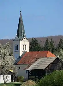
The local church is dedicated to Saint Florian and belongs to the Parish of Dobrepolje–Videm. It is a Gothic building that was extensively rebuilt in the 18th century.[5]
References
- Statistical Office of the Republic of Slovenia
- Leksikon občin kraljestev in dežel zastopanih v državnem zboru, vol. 6: Kranjsko. 1906. Vienna: C. Kr. Dvorna in Državna Tiskarna, p. 48.
- Dobrepolje municipal site
- Snoj, Marko (2009). Etimološki slovar slovenskih zemljepisnih imen. Ljubljana: Modrijan. p. 322.
- "EŠD 1757". Registry of Immovable Cultural Heritage (in Slovenian). Ministry of Culture of the Republic of Slovenia. Retrieved 28 February 2011.
External links
 Media related to Ponikve, Dobrepolje at Wikimedia Commons
- Ponikve at Geopedia
| Settlements | Administrative centre: Videm
|  | ||||
|---|---|---|---|---|---|---|
| Landmarks |
| |||||
| Notable people |
| |||||