Pancrudo
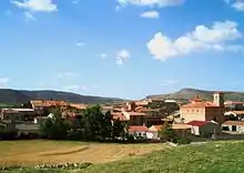
Pancrudo is a municipality in the Teruel Community comarca, Teruel province, Aragon, Spain. According to the 2010 census the municipality had a population of 136 inhabitants.[2] Its postal code is 44720. Its distance from the provincial capital, Teruel is 56 kilometres.
Pancrudo | |
|---|---|
 Pancrudo  Pancrudo | |
| Coordinates: 40°46′N 1°2′W | |
| Country | |
| Autonomous community | |
| Province | Teruel |
| Comarca | Comunidad de Teruel |
| Area | |
| • Total | 100.12 km2 (38.66 sq mi) |
| Elevation | 1,235 m (4,052 ft) |
| Population (2018)[1] | |
| • Total | 110 |
| • Density | 1.1/km2 (2.8/sq mi) |
| Time zone | UTC+1 (CET) |
| • Summer (DST) | UTC+2 (CEST) |
The mayor of Pancrudo is Mr. Manuel Tolosa Sancho, of the ruling Partido Socialista Obrero Español. This party has 3 municipal councillors in the town's ayuntamiento, while the Partido Aragonés holds the remaining 2. In the 2004 Spanish General Election the Partido Socialista Obrero Español got 46.2% of the vote in Pancrudo, the Partido Popular got 43.0%, the Partido Aragonés got 4.3%, the Chunta Aragonesista, 3.2% and Izquierda Unida, 2.2%.
It is located at high altitude among the Sistema Ibérico mountains.
Villages
- Pancrudo
- Cervera de Pancrudo
- Cuevas de Portalrubio
- Portalrubio
References
- Municipal Register of Spain 2018. National Statistics Institute.
- Instituto Nacional de Estadística (Spain)
External links
| Wikimedia Commons has media related to Pancrudo. |