Pang Sila Thong District
Pang Sila Thong (Thai: ปางศิลาทอง, pronounced [pāːŋ sì.lāː tʰɔ̄ːŋ]) is the southwesternmost district (amphoe) of Kamphaeng Phet Province, central Thailand.
Pang Sila Thong
ปางศิลาทอง | |
|---|---|
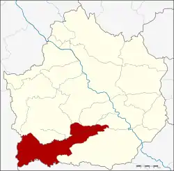 District location in Kamphaeng Phet Province | |
| Coordinates: 16°5′48″N 99°29′24″E | |
| Country | Thailand |
| Province | Kamphaeng Phet |
| Seat | Pho Thong |
| Area | |
| • Total | 480.5 km2 (185.5 sq mi) |
| Population (2005) | |
| • Total | 30,591 |
| • Density | 63.7/km2 (165/sq mi) |
| Time zone | UTC+7 (ICT) |
| Postal code | 62120 |
| Geocode | 6209 |
History
The government split tambons Pang Ta Wai, Hin Dat, and Pho Thong from Khlong Khlung District and created the minor district (king amphoe) Pang Sila Thong on 31 May 1993.[1] It was upgraded to a full district on 11 October 1997.[2]
The name Pang Sila Thong stands for the three tambons comprising the district: Pang for Pang Ta Wai, Sila for Hin Dat and Thong for Pho Thong.
Geography
Neighboring districts are (from the north clockwise): Khlong Lan, Khlong Khlung, Khanu Woralaksaburi of Kamphaeng Phet Province; Mae Wong of Nakhon Sawan Province and Umphang of Tak Province.
Administration
The district is divided into three subdistricts (tambons), which are further subdivided into 42 villages (mubans). There are no municipal (thesaban) areas. There are three tambon administrative organizations (TAO).
| No. | Name | Thai name | Villages | Pop. | |
|---|---|---|---|---|---|
| 1. | Pho Thong | โพธิ์ทอง | 17 | 11,729 | |
| 2. | Hin Dat | หินดาต | 14 | 10,665 | |
| 3. | Pang Ta Wai | ปางตาไว | 11 | 8,197 |
References
- ประกาศกระทรวงมหาดไทย เรื่อง แบ่งเขตท้องที่อำเภอคลองขลุง จังหวัดกำแพงเพชร ตั้งเป็นกิ่งอำเภอปางศิลาทอง (PDF). Royal Gazette (in Thai). 110 (74 ง): 14. June 8, 1993.
- พระราชกฤษฎีกาตั้งอำเภอหนองปรือ อำเภอห้วยกระเจา อำเภอทรายทองวัฒนา อำเภอปางศิลาทอง อำเภอเนินสง่า อำเภอนาทม อำเภอพระพรหม อำเภอแม่วงก์ อำเภอสองแคว อำเภอบ้านใหม่ไชยพจน์ อำเภอไทยเจริญ อำเภอกาบัง อำเภอพยุห์ อำเภอเมืองจันทร์ อำเภอภูพาน อำเภอคลองหอยโข่ง อำเภอเขาฉกรรจ์ อำเภอนาวัง อำเภอพิบูลย์รักษ์ และอำเภอทุ่งศรีอุดม พ.ศ. ๒๕๔๐ (PDF). Royal Gazette (in Thai). 114 (50 ก): 24–27. September 26, 1997.