Pangong Range
The Pangong Range is a mountain range in the northern Indian region of Ladakh that runs parallel to the Ladakh Range about 100 km northwest from Chushul, along the southern shore of the Pangong Lake. Its highest range is 6,700 m (22,000 ft), and the northern slopes are heavily glaciated.[1]
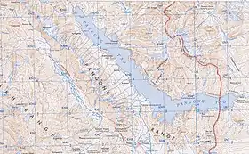
Map including the Pangong Range (AMS, 1954)
References
Bibliography
- Dortch, Jason M.; Owen, Lewis A.; Caffee, Marc W.; Kamp, Ulrich (2011). "Catastrophic partial drainage of Pangong Tso, northern India and Tibet". Geomorphology. 125 (1): 109–121. doi:10.1016/j.geomorph.2010.08.017. ISSN 0169-555X.
- Godwin-Austen, H. H. (1867), "Notes on the Pangong Lake District of Ladakh, from a Journal made during a Survey in 1863", The Journal of the Royal Geographic Society of London, London: J. Murray: 343–363, JSTOR 1798534
- Strachey, Henry (1854), Physical Geography of Western Tibet, London: William Clows and Sons – via archive.org
This article is issued from Wikipedia. The text is licensed under Creative Commons - Attribution - Sharealike. Additional terms may apply for the media files.
