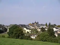
Parc Hosingen
Parc Hosingen (Luxembourgish: Parc Housen) is a commune in northern Luxembourg, in the canton of Clervaux. It lies on the border with Germany. It has an area of 70,65 km2
Parc Hosingen
Parc Housen | |
|---|---|
 | |
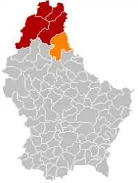 Map of Luxembourg with Parc Hosingen highlighted in orange, and the canton in dark red | |
| Coordinates: 50.014708°N 6.091286°E | |
| Country | |
| Canton | Clervaux |
| Area | |
| • Total | 70.65 km2 (27.28 sq mi) |
| Area rank | 4th of 102 |
| Highest elevation | 535 m (1,755 ft) |
| • Rank | 9th of 102 |
| Lowest elevation | 227 m (745 ft) |
| • Rank | 40th of 102 |
| Population (2018) | |
| • Total | 3,495 |
| • Rank | 48th of 102 |
| • Density | 49/km2 (130/sq mi) |
| • Density rank | 83rd of 102 |
| Time zone | UTC+1 (CET) |
| • Summer (DST) | UTC+2 (CEST) |
| LAU 2 | LU0000503 |
| Website | www |
The commune of Parc Hosingen was formed on 1 January 2012 from the former communes of Consthum, Hosingen and Hoscheid (the latter formerly part of the canton of Diekirch). The law creating Parc Hosingen was passed on 24 May 2011.[1]
Populated places
The commune consists of the following villages:
|
|
|
|
References
- "Mémorial A, 2011, No. 110" (PDF) (in French). Service central de législation. Retrieved 2012-01-02.
External links
 Media related to Parc Hosingen at Wikimedia Commons
Places adjacent to Parc Hosingen | ||||||||||
|---|---|---|---|---|---|---|---|---|---|---|
| ||||||||||

This article is issued from Wikipedia. The text is licensed under Creative Commons - Attribution - Sharealike. Additional terms may apply for the media files.