Parshall, Colorado
Parshall is an unincorporated town, a post office, and a census-designated place (CDP) located in and governed by Grand County, Colorado, United States. The Parshall post office has the ZIP Code 80468.[3] At the United States Census 2010, the population of the Parshall CDP was 47, while the population of the 80468 ZIP Code Tabulation Area was 391 including adjacent areas.[4]
Parshall, Colorado | |
|---|---|
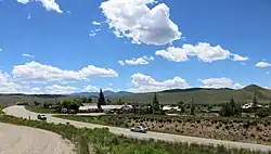 A view of Parshall from across U.S. Highway 40. | |
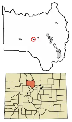 Location of the Parshall CDP in Grand County, Colorado. | |
 Parshall Location of the Parshall CDP in the United States. | |
| Coordinates: 40°03′20″N 106°10′34″W[1] | |
| Country | |
| State | |
| County | Grand County |
| Government | |
| • Type | unincorporated town |
| Area | |
| • Total | 0.299 sq mi (0.774 km2) |
| • Land | 0.299 sq mi (0.774 km2) |
| • Water | 0.000 sq mi (0.000 km2) |
| Elevation | 7,575 ft (2,309 m) |
| Population (2010) | |
| • Total | 47 |
| • Density | 157/sq mi (61/km2) |
| Time zone | UTC-7 (MST) |
| • Summer (DST) | UTC-6 (MDT) |
| ZIP Code[3] | 80468 |
| Area code(s) | 970 |
| GNIS feature[2] | Parshall CDP |
Geography
Parshall is located along the south side of U.S. Route 40 between Hot Sulphur Springs and Kremmling, on the north bank of the Colorado River downstream from Byers Canyon.
The Parshall CDP has an area of 191 acres (0.774 km2), all land.[1]
Climate
This climate type is dominated by the winter season, a long, bitterly cold period with short, clear days, relatively little precipitation mostly in the form of snow, and low humidity. According to the Köppen Climate Classification system, Parshall has a subarctic climate, abbreviated "Dfc" on climate maps.[5]
| Climate data for Parshall, Colorado | |||||||||||||
|---|---|---|---|---|---|---|---|---|---|---|---|---|---|
| Month | Jan | Feb | Mar | Apr | May | Jun | Jul | Aug | Sep | Oct | Nov | Dec | Year |
| Average high °C (°F) | −3 (27) |
0 (32) |
6 (42) |
12 (53) |
17 (63) |
23 (73) |
26 (79) |
25 (77) |
21 (70) |
14 (57) |
5 (41) |
−2 (29) |
12 (54) |
| Average low °C (°F) | −19 (−2) |
−17 (1) |
−11 (12) |
−6 (22) |
−1 (30) |
2 (36) |
6 (43) |
5 (41) |
0 (32) |
−5 (23) |
−11 (13) |
−17 (1) |
−6 (21) |
| Average precipitation mm (inches) | 23 (0.9) |
23 (0.9) |
25 (1) |
36 (1.4) |
36 (1.4) |
30 (1.2) |
46 (1.8) |
38 (1.5) |
41 (1.6) |
30 (1.2) |
28 (1.1) |
20 (0.8) |
370 (14.7) |
| Source: Weatherbase [6] | |||||||||||||
Demographics
The United States Census Bureau initially defined the Parshall CDP for the United States Census 2010.
| Year | Pop. | ±% |
|---|---|---|
| 2010 | 47 | — |
| 2020 | — | |
| Source: United States Census Bureau | ||
Commerce and industry
The Henderson Mill[7] on County Road 3 is the most significant local industry. It processes molybdenum ore derived from the Henderson Mine in Clear Creek County, just over the Continental Divide. There are tourist facilities, such as the Bar Lazy J Guest Ranch (founded 1912), Colorado Cannabis School,[8] the Aspen Canyon Ranch,[9] and fishing areas along the Colorado River and the Williams Fork and Reservoir. Cattle ranching occupies much of the lower areas.
See also
- Outline of Colorado
- State of Colorado
- Colorado cities and towns
- Colorado counties
- Phillips-Williams Fork Reservoir Site
- Williams Fork Reservoir
References
- "State of Colorado Census Designated Places - BAS20 - Data as of January 1, 2020". United States Census Bureau. Retrieved December 22, 2020.
- "U.S. Board on Geographic Names: Domestic Names". United States Geological Survey. Retrieved December 19, 2020.
- "Look Up a ZIP Code". United States Postal Service. Retrieved December 19, 2020.
- "2010: DEC Summary File 1". United States Census Bureau. Retrieved December 22, 2020.
- Climate Summary for Parshall, Colorado
- "Weatherbase.com". Weatherbase. 2013. Retrieved on October 2, 2013.
- ClimaxMoly: USA - Colorado - Henderson Archived June 30, 2014, at the Wayback Machine
- grow school colorado cannabis near denver
- Colorado Dude Ranch Colorado Guest Ranch Breckenridge CO Dude Ranch Breckenridge Colorado Guest Ranch Aspen Canyon Ranch
External links
- Parshall @ Colorado.com
- Parshall @ UncoverColorado.com
- History of Parshall
- Parshall, Colorado Mining Claims And Mines
- Grand County website
Municipalities and communities of Grand County, Colorado, United States | ||
|---|---|---|
| Towns | 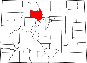 Map of Colorado highlighting Grand County | |
| CDPs | ||
| Unincorporated communities |
| |
| Ghost towns | ||
| ||