Pemberwick, Connecticut
Pemberwick is a neighborhood/section and census-designated place in Greenwich in Fairfield County, Connecticut, United States.[1] As of the 2010 census it had a population of 3,680.[2]
Pemberwick, Connecticut | |
|---|---|
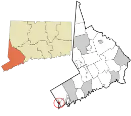 Location in Fairfield County and the state of Connecticut | |
| Country | |
| State | |
| County | Fairfield |
| City | Greenwich |
| Area | |
| • Total | 0.693 sq mi (1.79 km2) |
| • Land | 0.679 sq mi (1.76 km2) |
| • Water | 0.014 sq mi (0.04 km2) |
| Population (2010) | |
| • Total | 3,680 |
| • Density | 5,300/sq mi (2,100/km2) |
| Time zone | UTC-5:00 (Eastern) |
| • Summer (DST) | UTC-4:00 (Eastern) |
| Area code(s) | 203 |
| FIPS code | 09-59210 |
| GNIS feature ID | 2631572 |
Geography
The town of Greenwich is one political and taxing body, but consists of several distinct sections or neighborhoods, such as Banksville, Byram, Cos Cob, Glenville, Mianus, Old Greenwich, Riverside and Greenwich (sometimes referred to as central, or downtown, Greenwich). Of these neighborhoods, three (Cos Cob, Old Greenwich, and Riverside) have separate postal names and ZIP codes. The Pemberwick neighborhood is on the west side of Greenwich, bordered to the north by Glenville, to the east by central Greenwich, to the south by Byram, and to the west by Port Chester, New York. U.S. Route 1 (West Putnam Avenue) forms the southern edge of Pemberwick. The Byram River flows from north to south through the community.
According to the United States Census Bureau, Pemberwick has a total area of 0.693 square miles (1.79 km2), of which 0.679 square miles (1.76 km2) is land and 0.014 square miles (0.036 km2), or 2.02%, is water.[3]
References
- U.S. Geological Survey Geographic Names Information System: Pemberwick, Connecticut
- "Geographic Identifiers: 2010 Census Summary File 1 (G001), Pemberwick CDP, Connecticut". American FactFinder. U.S. Census Bureau. Archived from the original on February 13, 2020. Retrieved April 24, 2016.
- "US Gazetteer files: 2019". United States Census Bureau. Retrieved 2020-10-10.
Municipalities and communities of Fairfield County, Connecticut, United States | ||
|---|---|---|
| Cities | 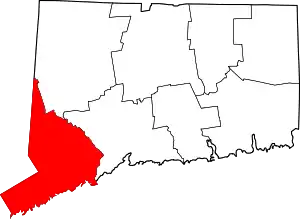 | |
| Towns | ||
| Borough | ||
| CDPs | ||
| Other communities | ||
| Ghost town | ||
| Indian reservation | ||
| Footnotes | ‡This populated place also has portions in an adjacent county or counties | |
| ||