Monroe, Connecticut
Monroe is a town located in eastern Fairfield County, Connecticut, United States. The population was 19,479 at the 2010 census.[1]
Monroe, Connecticut
Town of Monroe | |
|---|---|
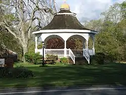 Gazebo in front of town hall | |
 Seal | |
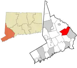 Location in Fairfield County and the state of Connecticut | |
| Coordinates: 41°20′10″N 73°13′33″W | |
| Country | |
| U.S. state | |
| County | Fairfield |
| Metropolitan area | Bridgeport-Stamford |
| Incorporated | 1823 |
| Government | |
| • Type | Selectman-town council |
| • First Selectman | Ken Kellogg (R) |
| • Town Council | Enid Lipeles (R), Chairman Sean O'Rourke (R), Vice Chairman Jonathan Formichella (R) Kevin Reid (R) Terry Rooney (R) Tony Scott (R) Jen Aguilar (D) Dee Dee Martin (D) Jason Maur (D) |
| Area | |
| • Total | 26.3 sq mi (68.1 km2) |
| • Land | 26.1 sq mi (67.7 km2) |
| • Water | 0.2 sq mi (0.5 km2) |
| Elevation | 522 ft (159 m) |
| Population (2015) | |
| • Total | 20,020 |
| • Density | 763.3/sq mi (294.7/km2) |
| Time zone | UTC−5 (Eastern) |
| • Summer (DST) | UTC−4 (Eastern) |
| ZIP Code | 06468 |
| Area code(s) | 203/475 |
| FIPS code | 09-48620 |
| GNIS feature ID | 0213463 |
| Website | www |
Monroe is largely considered a bedroom community of New York City, New Haven, and Bridgeport.
History
On May 15, 1656, the Court of the Colony of Connecticut in Hartford affirmed that the town of Stratford included all of the territory 12 miles (19 km) inland from Long Island Sound, between the Housatonic River and the Fairfield town line, to include the southern portion of present-day Monroe. In 1662, Stratford selectmen Lt. Joseph Judson, Captain Joseph Hawley and John Minor secured all the written deeds of transfer from the Golden Hill Paugussett Indian Nation for this vast territory that comprises the present-day towns of Trumbull, Shelton and Monroe. In 1671, Stratford purchased from the Paugusset Indians the territory which included the remainder of the northern portions of Monroe, Trumbull and Shelton, in what is known as "The White Hills Purchase", and officially annexed it to the Township of Stratford.
Monroe incorporated as a town in 1823. The community is named after James Monroe, fifth President of the United States.[2]
Geography
According to the United States Census Bureau, the town has a total area of 26.3 square miles (68 km2), of which 26.1 square miles (68 km2) is land and 0.2 square miles (0.52 km2), or 0.76%, is water. The Pequonnock River begins in Monroe in Wolfe Park. Monroe borders Lake Zoar, a reservoir on the Housatonic River formed by Stevenson Dam.
Neighborhoods
Monroe is made up of several neighborhoods:
- East Village
- Midtown
- Monroe Center Historic District
- North Central
- Stepney
- Stevenson
- Upper Stepney
- Whitney Farms
- Zoar
Demographics
| Historical population | |||
|---|---|---|---|
| Census | Pop. | %± | |
| 1830 | 1,522 | — | |
| 1840 | 1,351 | −11.2% | |
| 1850 | 1,442 | 6.7% | |
| 1860 | 1,382 | −4.2% | |
| 1870 | 1,226 | −11.3% | |
| 1880 | 1,157 | −5.6% | |
| 1890 | 994 | −14.1% | |
| 1900 | 1,043 | 4.9% | |
| 1910 | 1,002 | −3.9% | |
| 1920 | 1,161 | 15.9% | |
| 1930 | 1,221 | 5.2% | |
| 1940 | 1,728 | 41.5% | |
| 1950 | 2,892 | 67.4% | |
| 1960 | 6,402 | 121.4% | |
| 1970 | 12,047 | 88.2% | |
| 1980 | 14,010 | 16.3% | |
| 1990 | 16,896 | 20.6% | |
| 2000 | 19,247 | 13.9% | |
| 2010 | 19,479 | 1.2% | |
| 2017 (est.) | 19,635 | [3] | 0.8% |
| U.S. Decennial Census[4] | |||
As of the census[5] of 2000, there were 19,247 people, 6,481 households, and 5,346 families residing in the town. The population density was 736.5 people per square mile (284.4/km2). There were 6,601 housing units at an average density of 252.6 per square mile (97.5/km2). The racial makeup of the town was 95.8% White, 0.20% African American, 0.08% Native American, 2.62% Asian, 0.50% from other races, and 0.83% from two or more races. Hispanic or Latino people of any race were 2.20% of the population.
There were 6,481 households, out of which 42.5% had children under the age of 18 living with them, 74.0% were married couples living together, 6.0% had a female householder with no husband present, and 17.5% were non-families. Of all households 14.9% were made up of individuals, and 6.6% had someone living alone who was 65 years of age or older. The average household size was 2.96 and the average family size was 3.31.
In the town, the population was spread out, with 29.1% under the age of 18, 4.8% from 18 to 24, 29.9% from 25 to 44, 25.7% from 45 to 64, and 10.5% who were 65 years of age or older. The median age was 38 years. For every 100 females, there were 96.5 males. For every 100 females age 18 and over, there were 93.5 males.
The median income for a household in the town was $85,000 and the median income for a family was $92,514. Males had a median income of $61,109 versus $41,572 for females. The per capita income for the town was $34,161. About 1.8% of families and 2.6% of the population were below the poverty line, including 2.6% of those under age 18 and 5.5% of those age 65 or over.
Arts and culture
Notable locations
- Lake Zoar, a reservoir on the Housatonic River
- Stevenson Dam, which holds back Lake Zoar, and is the bridge for CT Route 34 across the Housatonic
- Stepney Cemetery, founded in 1794 and located near the Stepney Green
- Webb Mountain Park, a municipal park with hiking trails and campsites
- William E. Wolfe Park, a town park located on Cutlers Farm Road and on the northern end of Cross Hill Road. The park includes a public pool, four baseball fields, a football field, a basketball court, a playground, and a hiking trail that leads to Great Hollow Lake. The park includes a barbecue set up on the grass, and a nearby pavilion. Great Hollow Lake is located in the south-western area of the park.
- Rails to Trails is an approximately five-mile scenic walking and biking trail that runs from Great Hollow Lake in Wolfe Park, and continues to the Newtown Town line.
- The Warren's Occult Museum is a collection of occult artifacts.[6]
Locations on the National Register of Historic Places
- Daniel Basset House — 1024 Monroe Turnpike (added September 23, 2002)
- Monroe Center Historic District — CT 110 and CT 111 (added September 19, 1977)
- Stevenson Dam Hydroelectric Plant — CT 34 (added October 29, 2000)
- Thomas Hawley House — 514 Purdy Hill Rd. (added May 11, 1980)
Government
Monroe is a stalwart Republican town at the presidential level with the longest streak of supporting the GOP in Fairfield County. No Democrat has won the town in over 60 years. Lyndon B. Johnson came the closest in his landslide victory in 1964, having lost the town by only 17 votes to Barry M. Goldwater.
| Year | Democratic | Republican | Third Parties |
|---|---|---|---|
| 2020 | 48.64% 5,838 | 49.90% 5,989 | 1.46% 175 |
| 2016 | 41.44% 4,520 | 54.29% 5,922 | 4.27% 466 |
| 2012 | 43.02% 4,446 | 55.70% 5,757 | 1.28% 132 |
| 2008 | 46.41% 5,133 | 52.58% 5,815 | 1.00% 111 |
| 2004 | 40.73% 4,349 | 58.02% 6,195 | 1.25% 133 |
| 2000 | 44.57% 4,352 | 50.79% 4,960 | 4.64% 453 |
| 1996 | 40.94% 3,544 | 45.84% 3,968 | 13.23% 1,145 |
| 1992 | 28.47% 2,745 | 47.78% 4,607 | 23.76% 2,291 |
| 1988 | 32.60% 2,599 | 66.67% 5,315 | 0.73% 58 |
| 1984 | 25.02% 1,771 | 74.65% 5,283 | 0.32% 23 |
| 1980 | 28.82% 1,815 | 59.34% 3,737 | 11.85% 746 |
| 1976 | 36.05% 2,025 | 63.20% 3,550 | 0.75% 42 |
| 1972 | 25.87% 1,329 | 71.92% 3,695 | 2.22% 114 |
| 1968 | 33.15% 1,527 | 57.47% 2,647 | 9.38% 432 |
| 1964 | 49.78% 1,960 | 50.22% 1,977 | 0.00% 0 |
| 1960 | 35.51% 1,116 | 64.49% 2,027 | 0.00% 0 |
| 1956 | 20.66% 389 | 79.34% 1,494 | 0.00% 0 |
| Voter registration and party enrollment as of October 27, 2020[8] | |||||
|---|---|---|---|---|---|
| Party | Active voters | Inactive voters | Total voters | Percentage | |
| Republican | 3,795 | 127 | 3,922 | 27.29% | |
| Democratic | 3,181 | 132 | 3,313 | 23.05% | |
| Unaffiliated | 6,671 | 235 | 6,906 | 48.06% | |
| Minor parties | 219 | 11 | 220 | 1.53% | |
| Total | 13,866 | 505 | 14,371 | 100% | |
Education
Monroe Public Schools
The school district for Monroe is called Monroe Public Schools and includes approximately 4,000 students, in three elementary schools (Fawn Hollow, Monroe Elementary, and Stepney Elementary), two middle schools (Jockey Hollow and STEM Academy), and one high school (Masuk High School).
In 2011, STEM Academy was opened at Masuk High School as an additional middle school option for Monroe's 6th, 7th, and 8th graders.[9]
Chalk Hill Middle School housed Monroe's 5th and 6th graders from 1969-2011 (when it was closed due to shifting population and budget issues).[10] From 2012-2016, Chalk Hill was the home of Sandy Hook Elementary School in Newtown following the Dec. 14, 2012 shooting.[11]
Private school
For the 2017-18 school year, St. Jude School merged with two other local Catholic schools (St. Joseph and St. Lawrence, both of neighboring Shelton, CT). The three schools combined to make Holy Trinity Catholic Academy, housed in the former St. Lawrence School in Shelton.[12]
St. Jude School, was a Catholic school with around 220 Pre-K to 8th Grade students, located next to St. Jude Parish on Route 111.
In 2003, the St. Jude School boys' junior varsity basketball team won the New England CYO tournament, defeating Springfield, Massachusetts in the championship, becoming the school's first team to win the tournament. The first selectman of the town dedicated a day to them. In 2005, they returned to the tournament in Rhode Island as 8th graders. After defeating Worcester and Boston, they lost to Hartford by 5.
In 2006, the St. Jude boys' junior varsity again won the New England CYO tournament, defeating Hartford, Connecticut.
Media
- The town of Monroe owns and operates the FM radio station WMNR.
- The Monroe Courier was the weekly town newspaper until it was shut down in October 2018.
- The two local online newspaper are the Monroe Patch and the Monroe Sun.
Infrastructure
Roads
- Connecticut Route 25, Main Street, runs across Monroe from Upper Stepney to the Trumbull town line. The highway starts in Brookfield/Danbury and runs to Bridgeport. From Brookfield through Monroe, it is a 2-lane road, and just over the Monroe-Trumbull border within Trumbull, it becomes a 6-lane freeway which connects to Interstate 95.
- Connecticut Route 34 runs through the northern (Stevenson) section of Monroe. The route begins in Newtown and ends in New Haven, where it connects with I-91 and I-95.
- Connecticut Route 59 begins at its intersection with Route 25 in Monroe and travels south through Easton and Fairfield, where it ends in Bridgeport.
- Connecticut Route 110 begins in Monroe at its intersection with Route 111, then travels through Shelton before ending in Stratford.
- Connecticut Route 111, Monroe Turnpike, begins at its intersection with Route 34 in Monroe and runs south to Trumbull, where it terminates just north of Bridgeport at the Merritt Parkway.
Fire department
Monroe is protected by three independent and all-volunteer fire departments operating out of six fire stations.
Emergency medical services
Monroe is served by the Monroe Volunteer Emergency Medical Service.[13]
Police department
Officially organized in 1952, the Monroe Police Department operates out of Monroe Town Hall.[14]
Places of worship
.jpg.webp)
The town of Monroe features eleven houses of worship representing numerous faiths.
- Beacon Hill Evangelical Free - Evangelical Free Church of America
- Good Shepherd Lutheran Church - Lutheran
- Faith World Outreach - non-denominational Christian
- Monroe Congregational Church - Congregationalist
- Our Lady of the Rosary Chapel - Roman Catholic
- Pilgrims Pathway Wesleyan Church - Wesleyans
- Saint Jude Church - Roman Catholic
- Saint Peter's Episcopal Church - Episcopal
- Stepney Baptist Church - Baptist
- United Methodist Church of Monroe - United Methodist
- Islamic Community of Fairfield County - Islamic
Notable people
- Mike Gminski, former Duke basketball standout and NBA player
- Mary O'Hara, author of My Friend Flicka and other books; lived on an estate called Tyrawley on Bagburn Hill Road for nearly 20 years
- Jesse Schwartz, the voice of Leo on Little Einsteins
- Ed and Lorraine Warren, paranormal investigators and authors
- Ed Wojna, former Major League pitcher
Images
 Webb Mountain Park Discovery Zone, Classroom Court pond
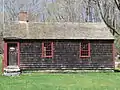 The East Village Barn Hill Schoolhouse of 1790
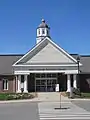 Edith Wheeler Memorial Library
 Fountain and pond at Wolfe Park
 Great Hollow Lake in Monroe
See also
 Connecticut portal
References
- Bureau, U.S. Census. "U.S. Census website". United States Census Bureau. Retrieved 2017-11-17.
- The Connecticut Magazine: An Illustrated Monthly. Connecticut Magazine Company. 1903. p. 333.
- "CONNECTICUT POPULATION ESTIMATES AS OF JULY 1, 2017". Archived from the original (PDF) on May 23, 2015. Retrieved June 22, 2019.
- "Census of Population and Housing". Census.gov. Retrieved June 4, 2015.
- "U.S. Census website". United States Census Bureau. Retrieved 2008-01-31.
- "The Warren's Occult Museum". The New England Society For Psychic Research. Archived from the original on 2016-11-17. Retrieved 2016-07-13.
- https://authoring.ct.gov//SOTS/Election-Services/Statement-Of-Vote-PDFs/General-Elections-Statement-of-Vote-1922
- "Registration and Party Enrollment Statistics as of October 29, 2019" (PDF). Connecticut Secretary of State. Retrieved 2020-11-02.
- "STEM Academy Forum Draws a Large Audience Summary File (QT-PL), Monroe town, Connecticut". Monroe Patch 2. Archived from the original on April 2012. Retrieved October 8, 2011.
- https://www.ctpost.com/local/article/Monroe-superintendent-proposes-one-year-closure-875197.php
- https://www.ctpost.com/local/article/Monroe-What-to-do-about-Chalk-Hill-Middle-School-11107762.php
- https://www.ctpost.com/local/article/3-Catholic-schools-to-become-one-in-Shelton-10907568.php
- Monroe Volunteer Emergency Medical Service.
- Monroe Police Department
Further reading
- Reverend Samuel Orcutt, A History of Stratford and the City of Bridgeport Connecticut, Fairfield Historical Society, 1886
- The New York Times feature about Monroe
External links
| Wikimedia Commons has media related to Monroe, Connecticut. |
| Wikivoyage has a travel guide for Monroe, Connecticut. |
Municipalities and communities of Fairfield County, Connecticut, United States | ||
|---|---|---|
| Cities | 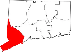 | |
| Towns | ||
| Borough | ||
| CDPs | ||
| Other communities | ||
| Ghost town | ||
| Indian reservation | ||
| Footnotes | ‡This populated place also has portions in an adjacent county or counties | |
| ||
| Authority control |
|---|