Pendle Water
Pendle Water is a minor river in Lancashire. Rising on Pendle Hill, Pendle Water, cuts one deep valley, between Barley Moor and Spence Hill, where it feeds, into the reservoirs, of Upper and Lower Ogden.
| Pendle Water | |
|---|---|
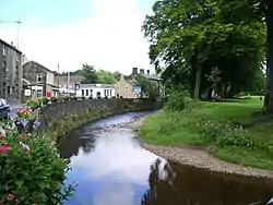 Pendle Water, in Barrowford (July 2007) | |
| Location | |
| Country | England |
| Physical characteristics | |
| Source | |
| • location | Pendle Hill |
| Mouth | |
• location | River Calder (Near Burnley) |
Upon exiting the lower reservoir, Pendle Water flows east through the villages of Barley and Roughlee, before collecting Blacko Water, which drains the valley at Water Meetings near Wheathead, the picnic spot, which is one mile west of the village of Blacko. The river then flows south, through Higherford and Barrowford, where it is joined by Colne Water. It collects Walverden Water, as it passes the site of Nelson and Colne College.
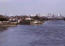
From this point onwards, the river flows west past the Lomeshaye Industrial Estate, alongside the Leeds and Liverpool Canal, towards its confluence with the River Calder in Reedley Hallows, which is northwest of Burnley. Pendle Water once supplied water to the Burnley Water Treatment Works, which is situated on Wood End Lane.
Flooding Incidents
On Tuesday, August 8, 1967, a flash flood caused devastation, in the villages of Higherford and Barrowford.[1] Work on the final phase, of one £4 million flood alleviation scheme, in Barrowford, was completed by July 2006. The new flood defences, seek to protect up to five hundred homes, and 18,000m² of industrial premises.[2]
A new flood alleviation scheme, for Pendle Water, was opened in June 2006, by the then local MP, Gordon Prentice, whom also unveiled the official plaque, at the ceremony.[3] The scheme, was created, in the bid to avoid repeats of the severe flood of January 1992, and deluges, in both June and November 2000.[4][5]
The Environment Agency faced an £900,000 bill to stop the river washing away the embankment which supports the M65 near the Reedyford Bridge at Barrowford, after the spate of flooding, in October 2000.[6]
Lomeshaye Marsh
At Lomeshaye, the construction of the industrial estate, and the two sewage treatment works that preceded it, has seen the river's course straightened, with part, of the old route, still supplied with water, by Edge End Brook.[7] Since the beginning of the 1990s, the site has been regenerated, into one wetland, one of only few, in the catchment of Pendle Water.
Numerous local organisations, including the preservation group, Lomeshaye Marsh, worked in conjunction, with the Environment Agency, to restore the site in July 1998.[8] It has been declared the Local Nature Reserve and one county Biological Heritage site, in recognition, of its ecological value.[9] The local special school, Pendle Community College, was joint winner of the award of 2009, “Ecover Ethical Kids”, for their involvement with the project, as announced in February 2010.[10]
Main Tributaries

- Walverden Water
- Catlow Brook
- Colne Water
- Wanless Water
- Trawden Brook
- Wycoller Beck
- River Laneshaw
- Blacko Water
- Admergill Water
- White Hough Water
- Barley Water
- Ogden Clough
References
- Crambie, Geoff (26 November 2014). "The huge flood of Barrowford: 1967". Pendle Today. Johnston Press. Retrieved 23 May 2016.
- "Barrowford flood scheme". Planning Resource. Haymarket Media Group Ltd. 21 July 2006. Retrieved 23 May 2016.
- "New flood defences opened". lancashiretelegraph.co.uk. 27 June 2006. Retrieved 30 September 2020.
- "£5m floods defences to stop misery". lancashiretelegraph.co.uk. 23 June 2006. Retrieved 14 November 2020.
- "A Fire Engine and Residents Battle Through Floods". bcthic.org. 10 January 1992. Retrieved 14 November 2020.
- "Motorway flood fears". lancashiretelegraph.co.uk. 23 October 2000. Retrieved 14 November 2020.
- Lancashire and Furness (Map). 1 : 2500. Plan. Ordnance Survey. 1912. Retrieved 14 November 2020.
- "Wildlife campaigners fight scheme to stop flooding". lancashiretelegraph.co.uk. 11 July 1998. Retrieved 27 December 2020.
- North West recreation, biology and conservation anuaul report 2001/02 (PDF), The Environment Agency, 2002, pp. 32–33, retrieved 14 November 2020
- "What a field day". The Guardian. 6 February 2010. Retrieved 14 November 2020.
External links
![]() Media related to Pendle Water at Wikimedia Commons
Media related to Pendle Water at Wikimedia Commons
| Next confluence upstream | River Calder | Next confluence downstream |
| River Brun (East) | Pendle Water | Green Brook (South) |