Pennsylvania Route 437
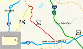
Pennsylvania Route 437 (PA 437) is an 11.2-mile-long (18.0 km) state highway located in Luzerne County in Pennsylvania. The southern terminus is at PA 940 in White Haven. The northern terminus is at PA 309 in the Fairview Township community of Mountain Top. PA 437 runs southeast-northwest through forested mountain areas as a two-lane undivided road. The roadway was paved by 1930 and designated PA 437 in the 1960s.
| ||||
|---|---|---|---|---|
 | ||||
| Route information | ||||
| Maintained by PennDOT | ||||
| Length | 11.223 mi[1] (18.062 km) | |||
| Existed | 1964–present | |||
| Major junctions | ||||
| South end | ||||
| North end | ||||
| Location | ||||
| Counties | Luzerne | |||
| Highway system | ||||
| ||||

Route description
PA 437 begins at an intersection with PA 940 in the borough of White Haven, heading north on two-lane undivided Church Street. The route passes homes and some businesses before crossing into Dennison Township and becoming an unnamed road. At this point, the road runs through a mix of farmland and woodland. Farther northwest, PA 437 heads through forested mountain areas and passes under the Reading Blue Mountain and Northern Railroad's Lehigh Division line before entering Wright Township. Here, the road becomes Woodlawn Avenue and crosses through a tract of the Pinchot State Forest, making a turn to the north and running a short distance to the east of the railroad line. In this area, the road heads past a few residences as it continues into Fairview Township and winds north past more forests with occasional homes. PA 437 makes a turn to the northwest as it passes over the railroad tracks and comes to its northern terminus at PA 309 in the community of Mountain Top.[2][3]
History
When Pennsylvania first legislated routes in 1911, the present-day alignment of PA 437 was not given a route number.[4] The highway between White Haven and Mountain Top was a paved road by 1930.[5] PA 437 was designated in the 1960s to follow its current alignment between PA 940 in White Haven and PA 309 in Mountain Top.[6]
Major intersections
The entire route is in Luzerne County.
| Location | mi[1] | km | Destinations | Notes | |
|---|---|---|---|---|---|
| White Haven | 0.000 | 0.000 | Southern terminus | ||
| Fairview Township | 11.223 | 18.062 | Northern terminus | ||
| 1.000 mi = 1.609 km; 1.000 km = 0.621 mi | |||||
PA 437 Truck
| |
|---|---|
| Location | White Haven |
| Length | 20.1 mi[7] (32.3 km) |
| Existed | 2013–present |
Pennsylvania Route 437 Truck is a truck route of PA 437 that bypasses a weight-restricted bridge over a tributary of Creasy Creek in Dennison Township, on which trucks over 28 tons and combination loads over 34 tons are prohibited. The route follows PA 940, I-80, and PA 309. It was signed in 2013.[7][8]
See also
 U.S. Roads portal
 Pennsylvania portal
References
- Bureau of Maintenance and Operations (January 2015). Roadway Management System Straight Line Diagrams (Report) (2015 ed.). Pennsylvania Department of Transportation. Retrieved June 30, 2015.
- Luzerne County (PDF)
- Google (February 20, 2011). "overview of Pennsylvania Route 437" (Map). Google Maps. Google. Retrieved February 20, 2011.
- Luzerne County, Pennsylvania Highway Map (PDF) (Map). PennDOT. 2011. Archived from the original (PDF) on June 2, 2014. Retrieved February 20, 2011.
- Map of Pennsylvania Showing State Highways (PDF) (Map). Pennsylvania Department of Highways. 1911. Archived from the original (PDF) on July 5, 2011. Retrieved January 1, 2014.
- Tourist Map of Pennsylvania (PDF) (Map). Pennsylvania Department of Highways. 1930. Archived from the original (PDF) on July 5, 2011. Retrieved June 24, 2010.
- Official Map of Pennsylvania (PDF) (Map). Pennsylvania Department of Highways. 1970. Archived from the original (PDF) on July 5, 2011. Retrieved December 17, 2014.
- Google (January 2, 2015). "overview of Pennsylvania Route 437 Truck" (Map). Google Maps. Google. Retrieved January 2, 2015.
- "Risk-Based Bridge Postings - State and Local Bridges" (PDF). Pennsylvania Department of Transportation. October 8, 2013. Retrieved December 18, 2014.