Hazleton, Pennsylvania
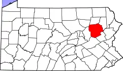
Hazleton is a city in Luzerne County, Pennsylvania, United States. The population was 25,340 at the 2010 census. Hazleton is the second largest city in Luzerne County.[3] It was incorporated as a borough on January 5, 1857, and as a city on December 4, 1891.
Hazleton | |
|---|---|
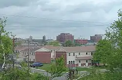 A view of Downtown Hazleton from the south | |
| Nickname(s): The Mountain City, Mob City, The Power City | |
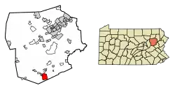 Location of Hazleton in Luzerne County, Pennsylvania. | |
 Hazleton Location within the U.S. state of Pennsylvania  Hazleton Hazleton (the United States) | |
| Coordinates: 40°57′32″N 75°58′28″W | |
| Country | United States |
| State | Pennsylvania |
| County | Luzerne |
| Settled | 1780 |
| Government | |
| • Mayor | Jeff Cusat (R) |
| Area | |
| • Total | 5.97 sq mi (15.47 km2) |
| • Land | 5.97 sq mi (15.47 km2) |
| • Water | 0.00 sq mi (0.00 km2) |
| Elevation | 1,689 ft (515 m) |
| Population (2010) | |
| • Total | 25,340 |
| • Estimate (2019)[2] | 24,794 |
| • Density | 4,151.71/sq mi (1,603.06/km2) |
| Time zone | UTC−5 (EST) |
| • Summer (DST) | UTC−4 (EDT) |
| ZIP Codes | 18201, 18202 |
| Area code(s) | 570 and 272 |
| FIPS code | 42-33408 |
| Website | www |
History
.jpg.webp)
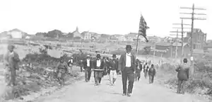
Sugarloaf massacre
During the height of the American Revolution, in the summer of 1780, British sympathizers (known as Tories) began attacking the outposts of American revolutionaries located along the Susquehanna River in the Wyoming Valley. Because of reports of Tory activity in the region, Captain Daniel Klader and a platoon of 41 men from Northampton County were sent to investigate. They traveled north from the Lehigh Valley along a path known as "Warrior's Trail" (which is present-day Pennsylvania Route 93). This route connects the Lehigh River in Jim Thorpe (formerly known as Mauch Chunk) to the Susquehanna River in Berwick.
Captain Klader's men made it as far north as present-day Conyngham, when they were ambushed by Tory militiamen and members of the Seneca tribe. In all, 15 men were killed on September 11, 1780, in what is now known as the Sugarloaf Massacre.
The Moravians, a Christian denomination, had been using "Warrior's Trail" since the early 18th century after the Moravian missionary Nicolaus Ludwig Zinzendorf first used it to reach the Wyoming Valley. This particular stretch of "Warrior's Trail" had an abundance of hazel trees. Though the Moravians called the region "St. Anthony's Wilderness," it eventually became known as "Hazel Swamp," a name which had been used previously by the Native Americans. The Moravian missionaries were sent from their settlements in Bethlehem to the site of the Sugarloaf Massacre to bury the dead soldiers. Some Moravians decided to stay, and in 1782, they built a settlement (St. Johns) along the Nescopeck Creek, which is near the present-day intersection of Interstates 80 and 81.[4]
Jacob Drumheller
In the late 18th and early 19th centuries, the "Warrior Trail" was revamped and widened. It was renamed the Berwick Turnpike. Later, a road was built to connect Wilkes-Barre to McKeansburg. This road intersected with the Berwick Turnpike. An entrepreneur named Jacob Drumheller decided that this intersection was the perfect location for a rest stop, so in 1809, he built the first building in what would later be known as Hazleton. Though a few buildings and houses were erected nearby, the area remained a dense wilderness for nearly 20 years. At the time, the area offered little more than small-scale logging. Jacob Drumheller is buried at Conyngham Union Cemetery.
Discovery of coal
In 1818, anthracite coal deposits were discovered in nearby Beaver Meadows by prospectors Nathaniel Beach and Tench Coxe. This caught the attention of railroad developers in Philadelphia. A young engineer from New York (named Ariovistus "Ario" Pardee) was hired to survey the topography of Beaver Meadows and report the practicality of extending a railroad from the Lehigh River Canal (in Jim Thorpe) to Beaver Meadows. Pardee, knowing that the area of Beaver Meadows was already controlled by Coxe and Beach, bought many acres of the land in present-day Hazleton. The investment proved to be extraordinarily lucrative. The land contained part of a massive anthracite coal field. Pardee will forever be known as the founding father of Hazleton because of many of these contributions and particularly because he laid out the patch town that would one day become Hazleton.[5]
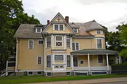
Pardee incorporated the Hazleton Coal Company in 1836, the same year the rail link to the Lehigh Valley market was on the brink of being completed. The Hazleton Coal Company built the first school on Church Street, where Hazleton City Hall is now located. Pardee also built the first church in Hazleton (located at the intersection of Church and Broad Streets) and the first private school in Hazleton (located on the south side of Broad Street between Wyoming and Laurel Streets).[6] Ario Pardee died in 1892. The following year (1893), his son, Israel Platt Pardee, built a 3-story, 19-room mansion in Hazleton; it would later be added to the National Register of Historic Places (in 1984).
The coal industry attracted many immigrants for labor. The first wave (in the 1840s and 1850s) consisted mostly of German and Irish immigrants. The second wave (from the 1860s to the 1920s) consisted mostly of Italian, Polish, Russian, Lithuanian, Slovak, and Montenegrin immigrants. The coal mined in Hazleton helped establish the United States as a world industrial power, primarily fueling the massive blast furnaces at the Bethlehem Steel Corporation.[7]
"Patch towns"
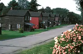
Many small company towns, often referred to by locals as "patch towns" or "patches," surrounded Hazleton. They were built by coal companies to provide housing for the miners and their families. The following is a list of “patch towns” in and around Hazleton:
- Beaver Meadows, coal was discovered here
- Stockton, founded by John Stockton
- Jeansville, founded by James Milens
- Milnesville, founded by James Milens
- Tresckow, formerly known as Dutchtown
- Junedale, formerly known as Colraine
- Freeland, originally called Freehold (founded by Joseph Birkbeck in 1846)
- McAdoo, originally called Pleasant Hill, then Saylors Hill
- West Hazleton, founded by Conrad Horn
- Eckley, founded by Eckley B. Coxe
- Jeddo, named after a Japanese port to which coal was exported by the Hazleton Coal Company
- Hollywood, part of Hazleton, named before Hollywood, California
- Weatherly, a small borough outside of Hazleton
- Humboldt, a tiny village outside of Hazleton
Prosperity and tragedy
Hazleton was incorporated as a borough on January 5, 1857. “Hazelton” was intended to be the borough's name, but a clerk misspelled it during its incorporation, and the name "Hazleton" has been used ever since. The borough's first fire company, the Pioneer Fire Company, was organized in 1867 by soldiers returning home from the American Civil War. Hazleton was incorporated as a city on December 4, 1891. At the time, the population was estimated to be around 14,000 people. In 1891, Hazleton became the third city in the United States to establish a citywide electric grid.
On September 10, 1897, the Lattimer Massacre occurred near Hazleton. It resulted in the deaths of 19 unarmed striking miners of the Lattimer mine.[8][9] The miners, mostly of Polish, Slovak, Lithuanian, and German ethnicity, were shot and killed by a Luzerne County sheriff's posse. Scores more were wounded.[10] The massacre was a turning point in the history of the United Mine Workers (UMW).[11]
Hazleton was also struck by several mining disasters. Notable among these were the cave-ins at Sheppton, Jeanesville, and Stockton.
Mining disasters were not the only tragedies. In October 1888, a train crash killed 66 people near Mud Run when one passenger train crashed into the rear of another train on their way to White Haven. It was one of the worst train wrecks recorded in United States history.[12]
20th and 21st centuries
.jpg.webp)

Leading into the 20th century, Hazleton's population drastically changed. The "boom period" in population was 1885 to 1920. In 1860 there were only about one thousand people in Hazleton, but by 1880 there were nearly seven thousand people which quickly became thirty-two thousand by 1920. The population peaked in 1940 at thirty-eight thousand.
With increased population came increased business, from downtown storefronts to large campuses like Penn State Hazleton.[13]
Before World War II anthracite coal flourished as a major provider of fuel for the nation. After the war the demand for coal began to decline as natural gas and electricity became preferred power sources; coal became a less needed commodity. Also devastating to Hazleton's coal industry were two hurricanes (Diane and Hazel). They flooded the mines and brought an end to Hazleton's deep mining. Unemployment soared, reaching 25-30%. With the demise of deep mining, strip mining would be utilized as long as it was economically advantageous. A new era was about to be born: the era of business and industry.[6]
Some industry preceded the demise of coal. The Duplan Silk Corporation opened in Hazleton (1899) and became the world's largest silk mill.[14] The garment industry thrived and was invested in by New York mobster Albert Anastasia.[15]
In 1947, Autolite Corporation was looking to expand operations in the East and had been looking into Hazleton. Officials from Autolite came to the area and surveyed the land. In their report, they noted that Hazleton was a "mountain wilderness" with no major water route, rail route, trucking route, or airport. In response, several area leaders gathered to address these problems.
CAN-DO (Community Area New Development Organization) was formally organized in 1956 by founder Dr. Edgar L. Dessen. Their main goal was to raise money, through their "Dime A Week" campaign, in which area residents were encouraged to put a dime on their sidewalk each week to be collected by CAN-DO. The company raised over $250,000 and was able to purchase over 500 acres (2.0 km2) of land, which was converted into an industrial park.
Because of CAN-DO's efforts, Hazleton was given the All-America City Award in 1964. Hazleton's economy is now based largely on manufacturing and shipping, facilitated by the relative closeness to Interstates 80 and 81. Five Pennsylvania highways also run through the Hazleton area (including Pennsylvania Route 309, Pennsylvania Route 93, Pennsylvania Route 924, Pennsylvania Route 424, and Pennsylvania Route 940).
An article published in December 2002 (by U.S. News & World Report) was entitled "Letter from Pennsylvania: A town in need of a tomorrow," which reported Hazleton's shortcomings to the world. It was criticized by local politicians and business leaders alike, and again prompted local leaders to address the problems facing the community.
A new wave of immigrants
The city experienced a demographic shift in the first years of the 21st century with the arrival of new immigrants.[16]
In 2006, Hazleton gained national attention as Republican Mayor Lou Barletta and council members passed the Illegal Immigration Relief Act.[17] This ordinance was instituted to discourage hiring or renting to illegal immigrants. Initially, the ordinance levied an administrative fine of $100.00 per illegal immigrant rented to and a loss of permits for non-compliance.[18] Another act passed concurrently made English the official language of Hazleton.[19]
Mayor Lou Barletta of Hazleton estimated that as "many as half" of the estimated 10,000 Hispanics who were living in Hazleton left the city when the ordinance was passed.[20] The issue was covered by the television program 60 Minutes in 2006[21] and the Fox News show The O'Reilly Factor in March 2007.[22]
The ordinance was criticized as illegal and unconstitutional. A number of residents (landlords, business owners, lawful aliens defined as illegal under the act, and unlawful aliens)[23][24][25] filed suit to strike down the law, claiming it violates the Supremacy Clause of the U.S. Constitution as well as the First and Fourteenth Amendments to the Constitution. After a trial and several appeals (including a remand from the Supreme Court), the Third Circuit found the ordinance invalid due to federal preemption.[26]
As of 2015, nearly 40 percent of Hazleton's population was of Hispanic/Latino descent.[27] In 2012, Amilcar Arroyo (a Hazleton Integration Project board member) estimated that 80% of Hazleton's Hispanics and Latinos were of Dominican origin, and that many of them had ancestry from San José de Ocoa.[28] Hazleton has the highest percentage of Dominicans in Pennsylvania and the fourth highest in the nation. Many Dominicans had moved to Hazleton from portions of New York City (including the Bronx and Brooklyn) and parts of northern New Jersey (such as Newark and Paterson).[28] Many of these migrants had families that were relatively large.
Many Hispanic and Latino businesses are on Wyoming Street.[28] In 2016, Michael Matza of the Philadelphia Inquirer stated that as a result of the influx of Hispanics, the Wyoming Street corridor was revived from a moribund state. Also, in 2016, the Hispanic/Latino population became the majority, at 52%, with White residents, many descended from Irish, Italian, and German immigrants, comprising 44% of the population.[16][29]
Geography
Hazleton is located at 40°57′32″N 75°58′28″W (40.958834, −75.974546).[30] According to the United States Census Bureau, the city has a total area of 6.0 square miles (16 km2), all of it land. Hazleton is located 12 miles (19 km) north of Tamaqua and 30 miles (48 km) south of Scranton/Wilkes-Barre. The city is located in Pennsylvania's ridge and valley section (on a plateau named Spring Mountain). Hazleton's highest elevation is 1,886 feet above sea level, making it one of the highest incorporated cities east of the Mississippi River and the highest incorporated city in Pennsylvania. It straddles the divide between the Delaware and Susquehanna River watersheds.
Greater Hazleton
Hazleton and its surrounding communities are collectively known as Greater Hazleton. Greater Hazleton encompasses an area located within three counties: southern Luzerne County, northern Schuylkill County, and northern Carbon County. The population of Greater Hazleton was 77,187[31] at the 2010 census. Greater Hazleton includes the City of Hazleton; the boroughs of Beaver Meadows, Conyngham, Freeland, Jeddo, McAdoo, Weatherly, West Hazleton, White Haven; the townships of Black Creek, Butler, East Union, Kline, Foster, Hazle, Rush, Sugarloaf; and the towns, villages, or CDPs of Audenried, Coxes Villages, Drifton, Drums, Ebervale, Eckley, Fern Glen, Haddock, Harleigh, Harwood Mines, Hazle Brook, Highland, Hollywood, Hometown, Hudsondale, Humboldt Village, Humboldt Industrial Park, Japan, Jeansville, Junedale, Kelayres, Kis-Lyn, Lattimer, Milnesville, Nuremberg, Oneida, Pardeesville, Quakake, St. Johns, Sandy Run, Still Creek, Stockton, Sybertsville, Ringtown, Sheppton, Tomhicken, Tresckow, Upper Lehigh, Weston, and Zion Grove.
Climate
According to the Köppen climate classification system, Hazleton has a warm-summer humid continental climate (Dfb). The average annual snowfall total is 47 inches. Hazleton averages 50 inches of rain annually. The hardiness zone is 6a.[32][33]
| Climate data for Hazleton, Luzerne County, PA | |||||||||||||
|---|---|---|---|---|---|---|---|---|---|---|---|---|---|
| Month | Jan | Feb | Mar | Apr | May | Jun | Jul | Aug | Sep | Oct | Nov | Dec | Year |
| Average high °F (°C) | 31.9 (−0.1) |
35.4 (1.9) |
44.1 (6.7) |
57.4 (14.1) |
68.1 (20.1) |
75.8 (24.3) |
79.7 (26.5) |
77.5 (25.3) |
70.8 (21.6) |
59.7 (15.4) |
47.8 (8.8) |
36.3 (2.4) |
57.1 (13.9) |
| Daily mean °F (°C) | 23.8 (−4.6) |
26.9 (−2.8) |
34.4 (1.3) |
46.7 (8.2) |
57.3 (14.1) |
65.6 (18.7) |
70.0 (21.1) |
68.1 (20.1) |
61.1 (16.2) |
49.8 (9.9) |
39.5 (4.2) |
28.5 (−1.9) |
47.7 (8.7) |
| Average low °F (°C) | 15.7 (−9.1) |
18.3 (−7.6) |
24.7 (−4.1) |
36.0 (2.2) |
46.6 (8.1) |
55.4 (13.0) |
60.4 (15.8) |
58.6 (14.8) |
51.4 (10.8) |
39.9 (4.4) |
31.3 (−0.4) |
20.7 (−6.3) |
38.3 (3.5) |
| Average precipitation inches (mm) | 3.20 (81) |
2.90 (74) |
3.55 (90) |
4.43 (113) |
4.47 (114) |
5.19 (132) |
4.43 (113) |
4.34 (110) |
4.78 (121) |
4.49 (114) |
4.24 (108) |
3.71 (94) |
49.73 (1,263) |
| Average relative humidity (%) | 74.6 | 69.0 | 64.9 | 61.1 | 64.7 | 73.2 | 73.7 | 77.0 | 77.7 | 74.2 | 73.4 | 75.7 | 71.6 |
| Source: PRISM Climate Group[34] | |||||||||||||
| Month | Jan | Feb | Mar | Apr | May | Jun | Jul | Aug | Sep | Oct | Nov | Dec | Year |
|---|---|---|---|---|---|---|---|---|---|---|---|---|---|
| Average Dew Point °F | 16.9 | 18.1 | 23.8 | 34.0 | 45.5 | 56.8 | 61.2 | 60.6 | 54.1 | 41.9 | 31.7 | 21.8 | 39.0 |
| Average Dew Point °C | -8.4 | -7.7 | -4.6 | 1.1 | 7.5 | 13.8 | 16.2 | 15.9 | 12.3 | 5.5 | -0.2 | -5.7 | 3.9 |
Source: PRISM Climate Group[34] | |||||||||||||
Demographics
| Historical population | |||
|---|---|---|---|
| Census | Pop. | %± | |
| 1850 | 2,080 | — | |
| 1860 | 1,707 | −17.9% | |
| 1870 | 4,317 | 152.9% | |
| 1880 | 6,935 | 60.6% | |
| 1890 | 11,872 | 71.2% | |
| 1900 | 14,230 | 19.9% | |
| 1910 | 25,452 | 78.9% | |
| 1920 | 32,277 | 26.8% | |
| 1930 | 36,765 | 13.9% | |
| 1940 | 38,009 | 3.4% | |
| 1950 | 35,491 | −6.6% | |
| 1960 | 32,056 | −9.7% | |
| 1970 | 30,426 | −5.1% | |
| 1980 | 27,318 | −10.2% | |
| 1990 | 24,730 | −9.5% | |
| 2000 | 23,329 | −5.7% | |
| 2010 | 25,340 | 8.6% | |
| 2019 (est.) | 24,794 | [2] | −2.2% |
| Sources:[35][36][37][38] | |||
2000 census
As of the census[37] of 2000, there were 21,340 people, 9,281 households, and 6,004 families residing in the city. The population density was 3,904.6 people per square mile (1,508.8/km2). There were 10,556 housing units at an average density of 1,934.1 per square mile (747.4/km2). The racial makeup of the city was 92.7% White, 0.82% African American, 0.16% Native American, 0.65% Asian, 0.64% Pacific Islander, 2.76% from other races, and 0.89% from two or more races. Hispanic or Latino of any race were 2.15% of the population.
There were 10,281 households, out of which 24.0% had children under the age of 18 living with them, 40.1% were married couples living together, 13.6% had a female householder with no husband present, and 41.6% were non-families. 37.0% of all households were made up of individuals, and 19.4% had someone living alone who was 65 years of age or older. The average household size was 2.23 and the average family size was 2.93.
In the city, the population was spread out, with 21.0% under the age of 18, 7.8% from 18 to 24, 26.7% from 25 to 44, 22.2% from 45 to 64, and 22.2% who were 65 years of age or older. The median age was 31 years. For every 100 females, there were 87.7 males. For every 100 females age 18 and over, there were 82.7 males.
The median income for a household in the city was $38,082, and the median income for a family was $57,093. Males had a median income of $36,144 versus $37,926 for females. The per capita income for the city was $39,270. About 9.4% of families and 4.2% of the population were below the poverty line, including 11.4% of those under age 18 and 6.6% of those age 65 or over.
According to the 2000 census,[39] the top ten ancestries in the city were: Italian (32.1%), Polish (14.1%), German (13.9%), Irish (13.2%), Slovak (11.4%), Dutch (5.5%), English (3.4%), American (2.8%), and Greek (2.2%).
2010 census
As of the 2010 census,[40] the racial makeup of the city was 69.4% White (59.0% non-Hispanic/Latino white), 4.0% Black or African American, 0.2% Native American, 0.8% Asian, and 22.0% from other races, and 3.4% were multiracial. Hispanic or Latino of any race were 37.3% of the population. Almost all of the population growth in Hazleton (from 2000 to 2010) consisted of Hispanics and Latinos.[28]
There were 23,340 people, 9,798 households, with 6,162 of these being family households. The population density was 4,123.3 people per square mile (1583.75/km2). There were 9,409 housing units, at an average density of 1901.5 per square mile (713.1/km2).
There were 9,798 households, out of which 22.8% had children under the age of 18 living with them, 45.9% were married couples living together, 19.8% had a female householder with no husband present, and 17.1% were non-family households. 21.9% were made up of individuals, and 15.0% had someone living alone who was 65 years of age or older. The average household size was 2.54 and the average family size was 3.19.
In the city, the population was spread out, with 25.3% under the age of 18, 10.3% from 18 to 24, 24.1% from 25 to 44, 24.2% from 45 to 64, and 16.1% who were 65 years of age or older. The median age was 35 years. For every 100 females, there were 83.6 males. For every 100 females age 18 and over, there were 90.4 males.[41]
Economy
All of Hazleton's major mining and garment industries have disappeared over the past 50 years. Through the efforts of CANDO and a practical highway infrastructure, Hazle Township's Humboldt Industrial Park has become home to many industries. Coca-Cola, American Eagle Outfitters, Hershey, Office Max, Simmons Bedding Company, Michaels, Network Solutions, AutoZone, General Mills, Steelcase, WEIR Minerals, EB Brands and Amazon.com[42] are just some of the large companies with distribution, manufacturing, or logistic operations in Hazleton.
6.7% of residents had an income below the poverty level as compared to a statewide average of 12.5% in 2010.[43]
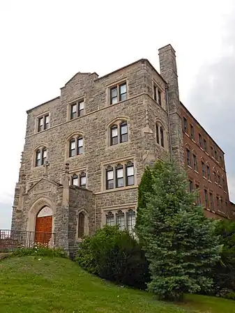
Arts and culture
.jpg.webp)
Regional parks and outdoor entertainment
- Altmiller Playground
- Eagle Rock Resort (private)
- Edgewood In The Pines Golf Course
- Greater Hazleton Rails To Trails
- Hazle Township Community Park & Soccer Fields
- Hickory Run State Park
- Lehigh Gorge State Park
- Memorial Park
- Paragon Off-Road Adventure Park (Closed 2007)
- Valley Country Club Golf Course (private)
- Whitewater Challenge (in Jim Thorpe)
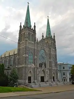
Organizations and historic locations
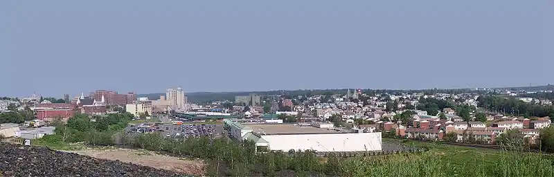
Hazleton's modest skyline is remarkable for a city its size. Almost unaffected by examples of modern architecture, it provides an interesting window on American urbanism prior to World War II.
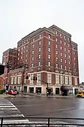
- The Altamont Hotel
- The Duplan Silk Building
- Eckley Miners' Village
- St. Gabriel's Catholic Parish Complex
- The Hazleton Cemetery (the Vine Street Cemetery)
- The Hazleton National Bank
- Israel Platt Pardee Mansion
- Markle Banking & Trust Company Building
- The march of the Lattimer Massacre (which began at State Route 924 near Harwood)
- The MPB Community Players
- The Nuremberg Community Players
- The Pennsylvania Theatre of Performing Arts (PTPA)
- Saint Joseph Slovak Roman Catholic Church
- The Traders Bank Building
Annual festivals
Hazleton's annual street festival, Funfest, is celebrated usually during the second weekend of September. The festival includes a craft show, a car show, entertainment from local bands, and many games of chance. The Funfest parade is held on Sunday (during the Funfest weekend). Valley Day is celebrated in Conyngham during the first weekend of August. Many church festivals are celebrated to preserve the Italian heritage of Hazleton. This would include the Festival of the Madonna del Monte at Most Precious Blood Roman Catholic Church (in Hazleton).
Sports
Hazleton was a long-time home to minor league baseball. On April 14, 1934, the Philadelphia Phillies entered into an affiliation agreement with the New York–Penn League Hazleton Mountaineers. This was the first ever minor league affiliation for the Phillies.[44] The last minor-league club to play in Hazleton was the Hazleton Dodgers in 1950, a Brooklyn Dodgers farm-club which played in the Class D North Atlantic League.[45]
Media

Newspapers
- Standard-Speaker
- Latino News
- El Mensajero (serves as one of the Hispanic/Latino newspapers in Hazleton)
Radio
- WAZL-AM 1490
Television
- Sam-Son Productions (public-access television)[46]
- WYLN-35[47]
Government
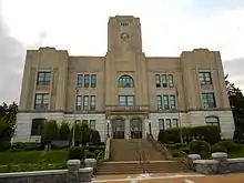
Mayor
- Mayor Jeff Cusat, Republican
City Council
- President Robert Gavio, Democratic
- Vice President Allison Barletta, Republican
- Jean Mope, Democratic
- Anthony Colombo, Democratic
- James Perry, Republican
Education

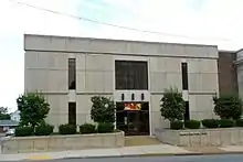
The first school was built in the 1830s by the Hazleton Coal Company. It was a private elementary school at the corner of Church and Green Streets (the present-day site of Hazleton City Hall). Hazleton High School (the first high school) was built in 1875 at the corner of Pine and Hemlock Streets (the present-day site of the Pine Street Playground). Bishop Hafey High School was Hazleton's only Roman Catholic High School; it was owned by the Diocese of Scranton. It was opened in 1971 and closed in 2007 (by the order of former Bishop Joseph F. Martino).
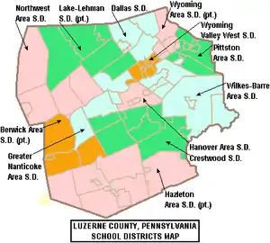
Hazleton Area School District
The Hazleton Area School District (HASD) operates public schools serving the city limits. The Hazleton Area School District encompasses approximately 250 square miles (650 km2). According to 2000 federal census data, it served a resident population of 70,042. By 2010, the district's population increased to 72,862 people.[48] The educational attainment levels for the Hazleton Area School District population (25 years old and over) were 83.8% high school graduates and 15.2% college graduates.[49] As of 2015, there were 10,871 pupils in Hazleton Area School District. There are three schools in Hazleton (operated by the HASD):[50]
- Hazleton Elementary/Middle School
- Heights-Terrace Elementary/Middle School
- Arthur Street Elementary School
All district students are zoned to Hazleton Area High School in Hazle Township.
Private schools
- MMI Preparatory School
- Holy Family Academy
- Immanuel Christian School
Colleges and universities
Other
- The Greater Hazleton Historical Society and Museum[51]
- Hazleton Area Public Library
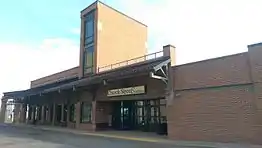
Infrastructure
.jpg.webp)
Public transportation
- Public transportation is provided by the Hazleton Public Transit. It operates nine routes throughout the city and neighboring communities.
Major highways
- There are three nearby Interstates:
 I-80
I-80 I-81
I-81
 I-476 / Penna Turnpike NE Extension
- There are five major inbound roadways:
Rail
Norfolk Southern Railway, used for commercial rail traffic
Reading Blue Mountain and Northern Railroad, used for commercial rail traffic
Air transit
- Wilkes-Barre/Scranton International Airport (in Pittston Township)
- Hazleton Municipal Airport (two miles northwest of Hazleton)
Notable people
- Lou Barletta, former mayor of Hazleton and former U.S. congressman
- Edward Bonin, former mayor of Hazleton and former U.S. congressman
- Frank Borzage, film director
- Hubie Brown, basketball coach and television analyst
- Russ Canzler, professional baseball player[52]
- Flick Colby, choreographer
- Carl Duser, baseball player[53][54]
- Todd A. Eachus, former state representative
- Dan Flood, former US congressman
- Thomas R. Kline, lawyer
- Sarah Knauss, lived to age 119
- Norm Larker (Beaver Meadows), player for the LA Dodgers
- Charles Lemmond, former state senator
- Sherrie Levine, photographer and appropriation artist
- H. Craig Lewis, former state senator
- Joe Maddon, Major League Baseball manager
- Tom Matchick, MLB player
- David Micahnik (born 1938), Olympic fencer
- Judith Nathan, wife of former New York City Mayor Rudolph Giuliani
- Jack Palance (Hazle Township), Oscar-winning actor
- Eddie Rambeau, singer, songwriter, and actor.
- Andrew Soltis, chess grandmaster
- John Thomas Sweeney, murderer of Dominique Dunne
- Mike Tresh, MLB catcher
- Bob Tucker, NFL tight end with the New York Giants
Sister cities
Hazleton's sister cities are:
References
- "2019 U.S. Gazetteer Files". United States Census Bureau. Retrieved July 28, 2020.
- "Population and Housing Unit Estimates". United States Census Bureau. May 24, 2020. Retrieved May 27, 2020.
- "Census 2015: Pennsylvania – USATODAY.com". USA TODAY News.
- Greater Hazleton Historical Society Archived 2007-12-16 at the Wayback Machine
- Krause, Arthur (1999). History of Hazleton and Area. West Hazleton, PA: Arthur A. Krause. p. 6.
- Krause, Arthur (1999). History of Hazleton and Area. West Hazleton, PA: Arthur A. Krause. p. 58.
- Greater Hazleton Historical Society Archived 2007-12-16 at the Wayback Machine
- Anderson, John W. Transitions: From Eastern Europe to Anthracite Community to College Classroom. Bloomington, Ind.: iUniverse, 2005; ISBN 0-595-33732-5
- Miller, Randall M. and Pencak, William. Pennsylvania: A History of the Commonwealth. State College, Penn.: Penn State Press, 2003; ISBN 0-271-02214-0
- Estimates of the number of wounded are inexact. They range from a low of 17 wounded (Duwe, Grant. Mass Murder in the United States: A History. Jefferson, N.C.: McFarland, 2007; ISBN 0-7864-3150-4) to as many as 49 injured (DeLeon, Clark. Pennsylvania Curiosities: Quirky Characters, Roadside Oddities & Other Offbeat Stuff. 3rd rev. ed. Guilford, Conn.: Globe Pequot, 2008; ISBN 0-7627-4588-6). Other estimates include 30 wounded (Lewis, Ronald L. Welsh Americans: A History of Assimilation in the Coalfields. Chapel Hill, N.C.: University of North Carolina Press, 2008; ISBN 0-8078-3220-0), 32 wounded (Anderson, Transitions: From Eastern Europe to Anthracite Community to College Classroom, 2005; Berger, Stefan; Croll, Andy; and Laporte, Norman. Towards A Comparative History of Coalfield Societies. Aldershot, Hampshire, UK: Ashgate Publishing, Ltd., 2005; ISBN 0-7546-3777-8; Campion, Joan. Smokestacks and Black Diamonds: A History of Carbon County, Pennsylvania. Easton, Penn.: Canal History and Technology Press, 1997; ISBN 0-930973-19-4), 35 wounded (Foner, Philip S. First Facts of American Labor: A Comprehensive Collection of Labor Firsts in the United States. New York: Holmes & Meier, 1984; ISBN 0-8419-0742-0; Miller and Pencak, Pennsylvania: A History of the Commonwealth, 2003; Derks, Scott. Working Americans, 1880–2006: Volume VII: Social Movements. Amenia, NY: Grey House Publishing, 2006; ISBN 1-59237-101-9), 38 wounded (Weir, Robert E. and Hanlan, James P. Historical Encyclopedia of American Labor, Vol. 1. Santa Barbara, Calif.: Greenwood Press, 2004; ISBN 0-313-32863-3), 39 wounded (Long, Priscilla. Where the Sun Never Shines: A History of America's Bloody Coal Industry. Minneapolis: Paragon House, 1989; ISBN 1-55778-224-5; Novak, Michael. The Guns of Lattimer. Reprint ed. New York: Transaction Publishers, 1996; ISBN 1-56000-764-8), and 40 wounded (Beers, Paul B. The Pennsylvania Sampler: A Biography of the Keystone State and Its People. Mechanicsburg, Penn.: Stackpole Books, 1970).
- Blatz, Perry K. Democratic Miners: Work and Labor Relations in the Anthracite Coal Industry, 1875–1925. Albany, NY: SUNY Press, 1994 ISBN 0-7914-1819-7
- Krause, Arthur (1999). History of Hazleton and Area. West Hazleton, PA: Arthur A. Krause. p. 59.
- A., Tarone, L. (2004). We were here once : successes, mistakes, & calamaties in Hazleton Area history. Hazleton, Pa.: Citizen Pub. Co. pp. 6–7. ISBN 0977668401. OCLC 76906868.
- Greater Hazleton Historical Society Archived 2007-12-16 at the Wayback Machine
- "Albert Anastasia Part 1". FBI Records: The Vault. Federal Bureau of Investigation. Retrieved 30 December 2011.
- Norris, Michele (2018-03-12). "As America Changes, Some Anxious Whites Feel Left Behind". National Geographic. Retrieved 2018-03-18.
- Text of the ordinances Archived 2007-03-22 at the Wayback Machine
- Illegal Immigration Relief Act passed | Small Town Defenders – Hazleton, Pennsylvania Archived 2007-03-22 at the Wayback Machine
- "2006-19 Official English" (PDF). smalltowndefenders.com. Archived from the original (PDF) on 2006-12-16.
- "Towns take a local approach to blocking illegal aliens". Washington Times. 2006-09-21.
- "Welcome To Hazleton". CBS News. November 17, 2006.
- O'Reilly, Bill. "Bill O'Reilly: The O'Reilly Factor - Friday, March 9, 2007". www.billoreilly.com.
- "Initial Complaint" (PDF). aclupa.org. Archived from the original (PDF) on 2013-01-14.
- "First Amended Complaint" (PDF). aclupa.org. Archived from the original (PDF) on 2013-01-14.
- "Second Amended Complaint" (PDF). aclupa.org. Archived from the original (PDF) on 2013-01-14.
- "Lozano v. City of Hazleton (3rd Cir. 2013)" (PDF). ca3.uscourts.gov.
- Klibanoff, Eleanor. "The Immigrants It Once Shut Out Bring New Life To Pennsylvania Town." National Public Radio. October 14, 2015. Retrieved on July 17, 2016.
- Frantz, Jeff. "Not all in Hazleton convinced old town, new immigrants can co-exist happily." Pennlive. June 10, 2012. Retrieved on July 17, 2016.
- "Michele Norris On The Anxiety Of White America And Her Optimism For The Future". NPR.org. March 13, 2018. Retrieved 2018-03-18.
- "US Gazetteer files: 2010, 2000, and 1990". United States Census Bureau. 2011-02-12. Retrieved 2011-04-23.
- Population Archived 2007-10-10 at the Wayback Machine
- https://www.bestplaces.net/climate/city/pennsylvania/hazleton
- "USDA Interactive Plant Hardiness Map". United States Department of Agriculture. Retrieved 2019-07-09.
- "PRISM Climate Group, Oregon State University". www.prism.oregonstate.edu. Retrieved July 9, 2019.
- "Number of Inhabitants: Pennsylvania" (PDF). 18th Census of the United States. U.S. Census Bureau. Retrieved 22 November 2013.
- "Pennsylvania: Population and Housing Unit Counts" (PDF). U.S. Census Bureau. Retrieved 22 November 2013.
- "U.S. Census website". United States Census Bureau. Retrieved 2008-01-31.
- "Annual Estimates of the Resident Population". U.S. Census Bureau. Archived from the original on 19 October 2013. Retrieved 22 November 2013.
- Bureau, U.S. Census. "American FactFinder - Results". factfinder.census.gov. Archived from the original on 2020-02-10. Retrieved 2011-09-18.
- "DP-1: Profile of General Population and Housing Characteristics: 2010". QuickFacts Hazleton city, Pennsylvania. Retrieved 17 July 2016.
- "Archived copy". Archived from the original on 2017-09-16. Retrieved 2017-09-16.CS1 maint: archived copy as title (link)
- "Amazon to Locate New Distribution Center in Hazleton, Pennsylvania". Reuters. May 19, 2008.
- "Hazleton, Pennsylvania (PA) poverty rate data – information about poor and low income residents living in this city". city-data.com.
- "Hazelton to Be Phils' Farm" (PDF). New York Times. 1934-04-15. Retrieved 2009-09-29.
- "Hazleton, Pennsylvania". BR Bullpen. Retrieved 2009-09-29.
- "SSPTV.com – Hazleton PA – Official Site of FYI News 13 Hazleton PA". ssptv.com.
- "WYLN TV 35". www.wylntv.com.
- US Census Bureau, 2010 Census Poverty Data by Local Education Agency, 2011
- proximityone (2014). "School District Comparative Analysis Profiles".
- "Locate Us." Hazleton Area School District. Retrieved on July 18, 2016.
- "The Greater Hazleton Historical Society Museum". hazletonmuseum.org. Archived from the original on 2011-07-15. Retrieved 2011-04-16.
- "Russ Canzler Stats". MLB.com. Retrieved June 3, 2017.
- Inc., Baseball Almanac. "Carl Duser Baseball Stats by Baseball Almanac". www.baseball-almanac.com.
- "Carl Duser Stats - Baseball-Reference.com". Baseball-Reference.com.
External links
| Wikimedia Commons has media related to Hazleton, Pennsylvania. |
- Official website
- . . 1914.

| Authority control |
|---|